 Add to Chrome
 Add to Firefox
 Add to Edge
CreativeVR: Diffusion-Prior-Guided Approach for Structure and Motion Restoration in Generative and Real Videos
Dec 12, 2025Modern text-to-video (T2V) diffusion models can synthesize visually compelling clips, yet they remain brittle at fine-scale structure: even state-of-the-art generators often produce distorted faces and hands, warped backgrounds, and temporally inconsistent motion. Such severe structural artifacts also appear in very low-quality real-world videos. Classical video restoration and super-resolution (VR/VSR) methods, in contrast, are tuned for synthetic degradations such as blur and downsampling and tend to stabilize these artifacts rather than repair them, while diffusion-prior restorers are usually trained on photometric noise and offer little control over the trade-off between perceptual quality and fidelity. We introduce CreativeVR, a diffusion-prior-guided video restoration framework for AI-generated (AIGC) and real videos with severe structural and temporal artifacts. Our deep-adapter-based method exposes a single precision knob that controls how strongly the model follows the input, smoothly trading off between precise restoration on standard degradations and stronger structure- and motion-corrective behavior on challenging content. Our key novelty is a temporally coherent degradation module used during training, which applies carefully designed transformations that produce realistic structural failures. To evaluate AIGC-artifact restoration, we propose the AIGC54 benchmark with FIQA, semantic and perceptual metrics, and multi-aspect scoring. CreativeVR achieves state-of-the-art results on videos with severe artifacts and performs competitively on standard video restoration benchmarks, while running at practical throughput (about 13 FPS at 720p on a single 80-GB A100). Project page: https://daveishan.github.io/creativevr-webpage/.
Self-Supervised Learning to Guide Scientifically Relevant Categorization of Martian Terrain Images
Apr 21, 2022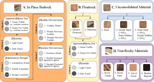
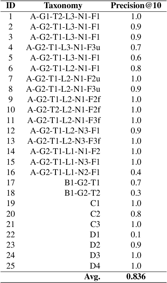
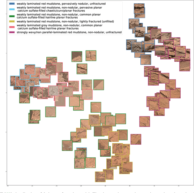
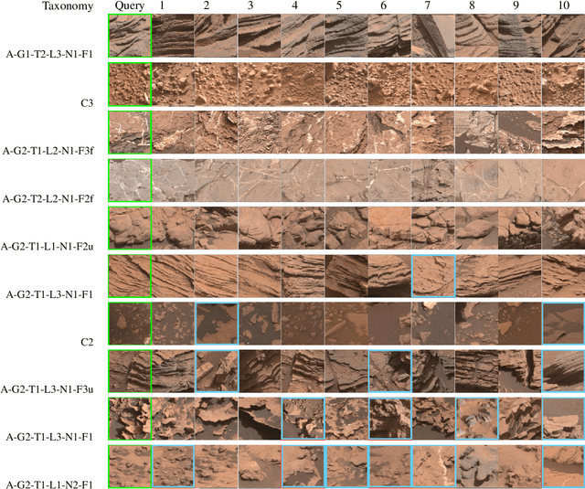
Automatic terrain recognition in Mars rover images is an important problem not just for navigation, but for scientists interested in studying rock types, and by extension, conditions of the ancient Martian paleoclimate and habitability. Existing approaches to label Martian terrain either involve the use of non-expert annotators producing taxonomies of limited granularity (e.g. soil, sand, bedrock, float rock, etc.), or rely on generic class discovery approaches that tend to produce perceptual classes such as rover parts and landscape, which are irrelevant to geologic analysis. Expert-labeled datasets containing granular geological/geomorphological terrain categories are rare or inaccessible to public, and sometimes require the extraction of relevant categorical information from complex annotations. In order to facilitate the creation of a dataset with detailed terrain categories, we present a self-supervised method that can cluster sedimentary textures in images captured from the Mast camera onboard the Curiosity rover (Mars Science Laboratory). We then present a qualitative analysis of these clusters and describe their geologic significance via the creation of a set of granular terrain categories. The precision and geologic validation of these automatically discovered clusters suggest that our methods are promising for the rapid classification of important geologic features and will therefore facilitate our long-term goal of producing a large, granular, and publicly available dataset for Mars terrain recognition.