 Add to Chrome
 Add to Firefox
 Add to Edge
Range Image-Based Implicit Neural Compression for LiDAR Point Clouds
Apr 24, 2025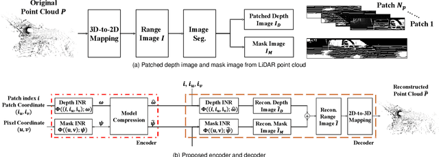
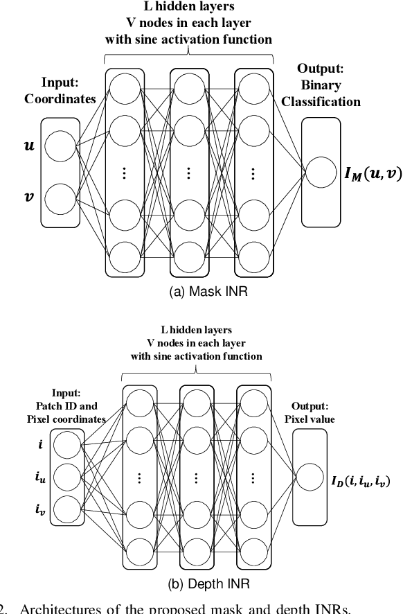
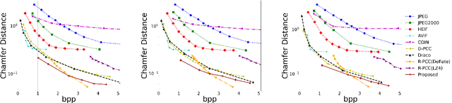
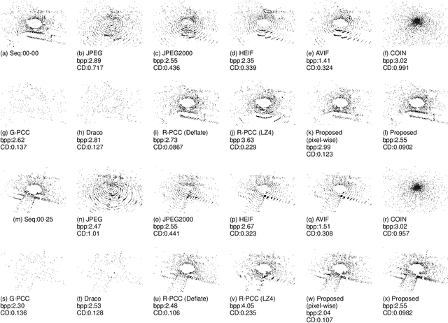
This paper presents a novel scheme to efficiently compress Light Detection and Ranging~(LiDAR) point clouds, enabling high-precision 3D scene archives, and such archives pave the way for a detailed understanding of the corresponding 3D scenes. We focus on 2D range images~(RIs) as a lightweight format for representing 3D LiDAR observations. Although conventional image compression techniques can be adapted to improve compression efficiency for RIs, their practical performance is expected to be limited due to differences in bit precision and the distinct pixel value distribution characteristics between natural images and RIs. We propose a novel implicit neural representation~(INR)--based RI compression method that effectively handles floating-point valued pixels. The proposed method divides RIs into depth and mask images and compresses them using patch-wise and pixel-wise INR architectures with model pruning and quantization, respectively. Experiments on the KITTI dataset show that the proposed method outperforms existing image, point cloud, RI, and INR-based compression methods in terms of 3D reconstruction and detection quality at low bitrates and decoding latency.
Learning Mobile CNN Feature Extraction Toward Fast Computation of Visual Object Tracking
Apr 03, 2021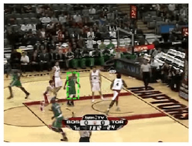
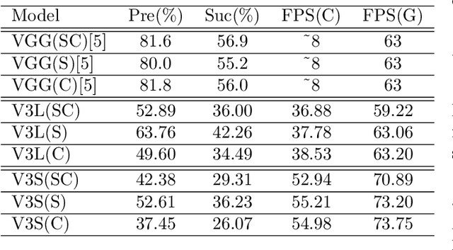
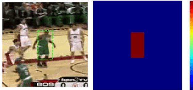
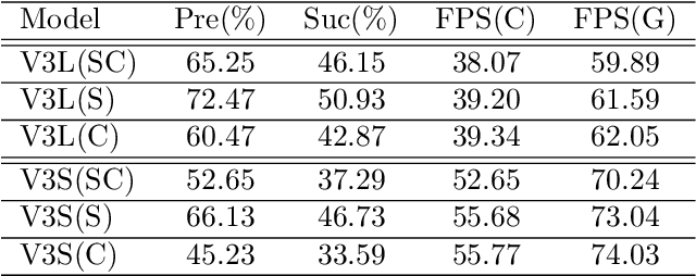
In this paper, we construct a lightweight, high-precision and high-speed object tracking using a trained CNN. Conventional methods with trained CNNs use VGG16 network which requires powerful computational resources. Therefore, there is a problem that it is difficult to apply in low computation resources environments. To solve this problem, we use MobileNetV3, which is a CNN for mobile terminals.Based on Feature Map Selection Tracking, we propose a new architecture that extracts effective features of MobileNet for object tracking. The architecture requires no online learning but only offline learning. In addition, by using features of objects other than tracking target, the features of tracking target are extracted more efficiently. We measure the tracking accuracy with Visual Tracker Benchmark and confirm that the proposed method can perform high-precision and high-speed calculation even in low computation resource environments.
CSI2Image: Image Reconstruction from Channel State Information Using Generative Adversarial Networks
Sep 16, 2020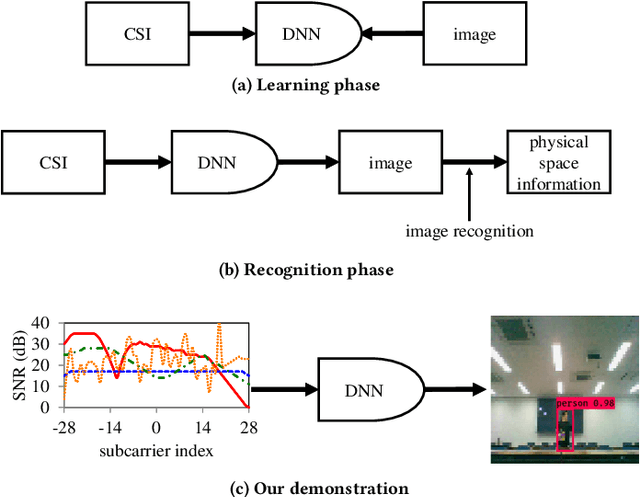
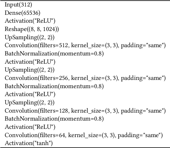
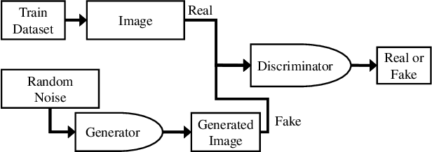
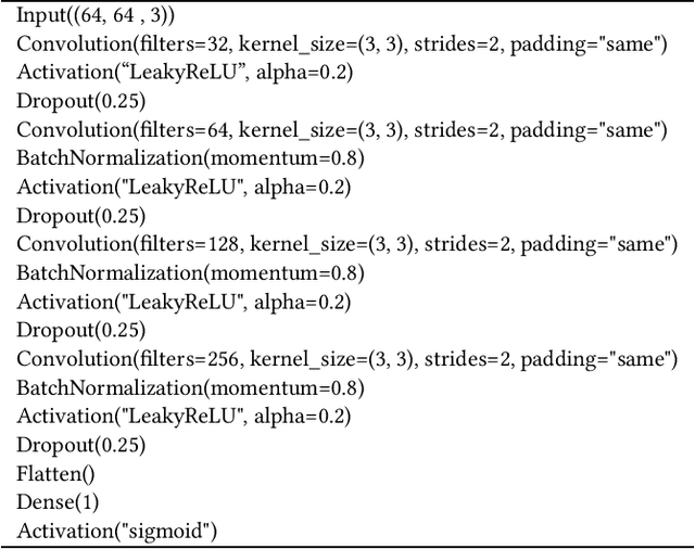
This study aims to find the upper limit of the wireless sensing capability of acquiring physical space information. This is a challenging objective, because at present, wireless sensing studies continue to succeed in acquiring novel phenomena. Thus, although a complete answer cannot be obtained yet, a step is taken towards it here. To achieve this, CSI2Image, a novel channel-state-information (CSI)-to-image conversion method based on generative adversarial networks (GANs), is proposed. The type of physical information acquired using wireless sensing can be estimated by checking wheth\-er the reconstructed image captures the desired physical space information. Three types of learning methods are demonstrated: gen\-er\-a\-tor-only learning, GAN-only learning, and hybrid learning. Evaluating the performance of CSI2Image is difficult, because both the clarity of the image and the presence of the desired physical space information must be evaluated. To solve this problem, a quantitative evaluation methodology using an object detection library is also proposed. CSI2Image was implemented using IEEE 802.11ac compressed CSI, and the evaluation results show that the image was successfully reconstructed. The results demonstrate that gen\-er\-a\-tor-only learning is sufficient for simple wireless sensing problems, but in complex wireless sensing problems, GANs are important for reconstructing generalized images with more accurate physical space information.
Wireless 3D Point Cloud Delivery Using Deep Graph Neural Networks
Jun 17, 2020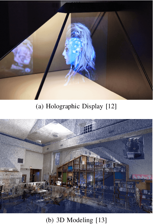
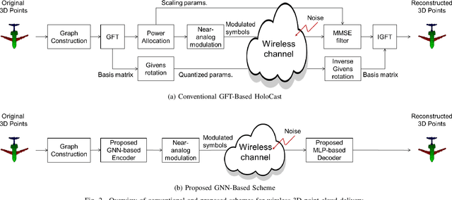
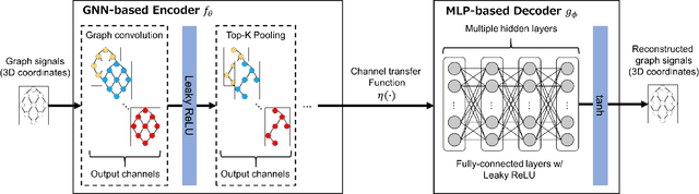
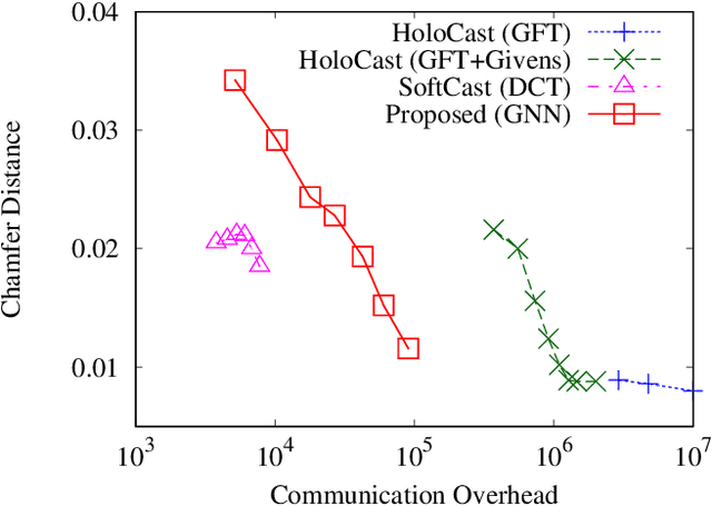
In typical point cloud delivery, a sender uses octree-based digital video compression to send three-dimensional (3D) points and color attributes over band-limited links. However, the digital-based schemes have an issue called the cliff effect, where the 3D reconstruction quality will be a step function in terms of wireless channel quality. To prevent the cliff effect subject to channel quality fluctuation, we have proposed soft point cloud delivery called HoloCast. Although the HoloCast realizes graceful quality improvement according to wireless channel quality, it requires large communication overheads. In this paper, we propose a novel scheme for soft point cloud delivery to simultaneously realize better quality and lower communication overheads. The proposed scheme introduces an end-to-end deep learning framework based on graph neural network (GNN) to reconstruct high-quality point clouds from its distorted observation under wireless fading channels. We demonstrate that the proposed GNN-based scheme can reconstruct clean 3D point cloud with low overheads by removing fading and noise effects.