 Add to Chrome
 Add to Firefox
 Add to Edge
Finding Optimal Trading History in Reinforcement Learning for Stock Market Trading
Feb 19, 2025


This paper investigates the optimization of temporal windows in Financial Deep Reinforcement Learning (DRL) models using 2D Convolutional Neural Networks (CNNs). We introduce a novel approach to treating the temporal field as a hyperparameter and examine its impact on model performance across various datasets and feature arrangements. We introduce a new hyperparameter for the CNN policy, proposing that this temporal field can and should be treated as a hyperparameter for these models. We examine the significance of this temporal field by iteratively expanding the window of observations presented to the CNN policy during the deep reinforcement learning process. Our iterative process involves progressively increasing the observation period from two weeks to twelve weeks, allowing us to examine the effects of different temporal windows on the model's performance. This window expansion is implemented in two settings. In one setting, we rearrange the features in the dataset to group them by company, allowing the model to have a full view of company data in its observation window and CNN kernel. In the second setting, we do not group the features by company, and features are arranged by category. Our study reveals that shorter temporal windows are most effective when no feature rearrangement to group per company is in effect. However, the model will utilize longer temporal windows and yield better performance once we introduce the feature rearrangement. To examine the consistency of our findings, we repeated our experiment on two datasets containing the same thirty companies from the Dow Jones Index but with different features in each dataset and consistently observed the above-mentioned patterns. The result is a trading model significantly outperforming global financial services firms such as the Global X Guru by the established Mirae Asset.
Gradient Reduction Convolutional Neural Network Policy for Financial Deep Reinforcement Learning
Aug 16, 2024


Building on our prior explorations of convolutional neural networks (CNNs) for financial data processing, this paper introduces two significant enhancements to refine our CNN model's predictive performance and robustness for financial tabular data. Firstly, we integrate a normalization layer at the input stage to ensure consistent feature scaling, addressing the issue of disparate feature magnitudes that can skew the learning process. This modification is hypothesized to aid in stabilizing the training dynamics and improving the model's generalization across diverse financial datasets. Secondly, we employ a Gradient Reduction Architecture, where earlier layers are wider and subsequent layers are progressively narrower. This enhancement is designed to enable the model to capture more complex and subtle patterns within the data, a crucial factor in accurately predicting financial outcomes. These advancements directly respond to the limitations identified in previous studies, where simpler models struggled with the complexity and variability inherent in financial applications. Initial tests confirm that these changes improve accuracy and model stability, suggesting that deeper and more nuanced network architectures can significantly benefit financial predictive tasks. This paper details the implementation of these enhancements and evaluates their impact on the model's performance in a controlled experimental setting.
CNN-DRL for Scalable Actions in Finance
Jan 10, 2024


The published MLP-based DRL in finance has difficulties in learning the dynamics of the environment when the action scale increases. If the buying and selling increase to one thousand shares, the MLP agent will not be able to effectively adapt to the environment. To address this, we designed a CNN agent that concatenates the data from the last ninety days of the daily feature vector to create the CNN input matrix. Our extensive experiments demonstrate that the MLP-based agent experiences a loss corresponding to the initial environment setup, while our designed CNN remains stable, effectively learns the environment, and leads to an increase in rewards.
Large-scale Building Height Retrieval from Single SAR Imagery based on Bounding Box Regression Networks
Nov 18, 2021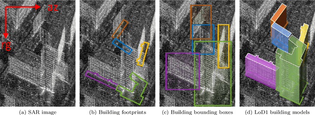
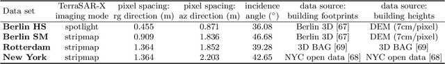
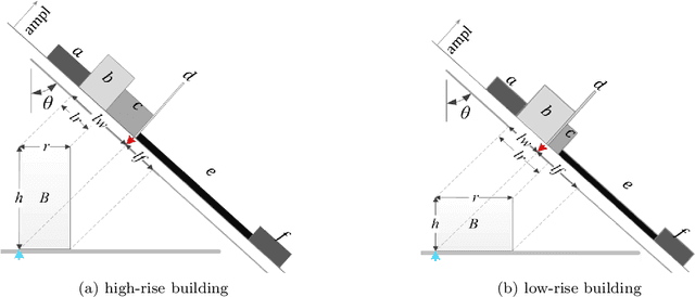
Building height retrieval from synthetic aperture radar (SAR) imagery is of great importance for urban applications, yet highly challenging owing to the complexity of SAR data. This paper addresses the issue of building height retrieval in large-scale urban areas from a single TerraSAR-X spotlight or stripmap image. Based on the radar viewing geometry, we propose that this problem can be formulated as a bounding box regression problem and therefore allows for integrating height data from multiple data sources in generating ground truth on a larger scale. We introduce building footprints from geographic information system (GIS) data as complementary information and propose a bounding box regression network that exploits the location relationship between a building's footprint and its bounding box, allowing for fast computation. This is important for large-scale applications. The method is validated on four urban data sets using TerraSAR-X images in both high-resolution spotlight and stripmap modes. Experimental results show that the proposed network can reduce the computation cost significantly while keeping the height accuracy of individual buildings compared to a Faster R-CNN based method. Moreover, we investigate the impact of inaccurate GIS data on our proposed network, and this study shows that the bounding box regression network is robust against positioning errors in GIS data. The proposed method has great potential to be applied to regional or even global scales.
Deep Learning Meets SAR
Jun 17, 2020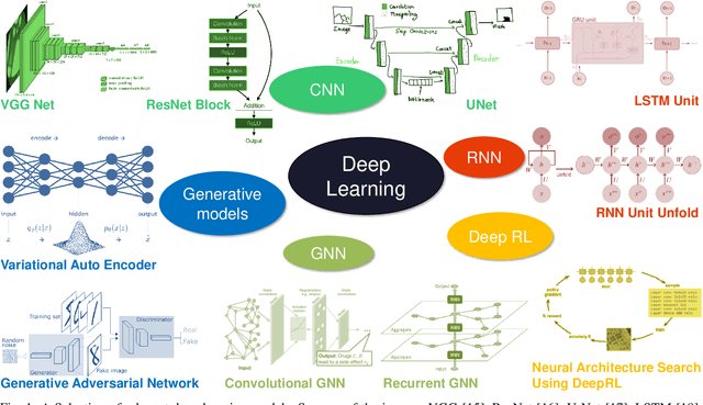
Deep learning in remote sensing has become an international hype, but it is mostly limited to the evaluation of optical data. Although deep learning has been introduced in SAR data processing, despite successful first attempts, its huge potential remains locked. For example, to the best knowledge of the authors, there is no single example of deep learning in SAR that has been developed up to operational processing of big data or integrated into the production chain of any satellite mission. In this paper, we provide an introduction to the most relevant deep learning models and concepts, point out possible pitfalls by analyzing special characteristics of SAR data, review the state-of-the-art of deep learning applied to SAR in depth, summarize available benchmarks, and recommend some important future research directions. With this effort, we hope to stimulate more research in this interesting yet under-exploited research field.