 Add to Chrome
 Add to Firefox
 Add to Edge
Risk-Adaptive Edge--Cloud Visual Reasoning for Communication-Efficient Autonomous Driving
Aug 15, 2026
Cloud-hosted vision-language models (VLMs) offer greater contextual reasoning capabilities than smaller onboard models, but frequent visual uploads increase communication overhead and add network and inference latency to tactical decisions. We present a risk-adaptive edge-cloud architecture in which onboard traffic assessment determines when cloud reasoning is requested. An onboard VLM and a lightweight detector capture temporal traffic conditions and path-relative hazards for conservative local response and selective cloud access. The cloud model provides tactical advice, while validation, vehicle control, and automatic emergency braking remain local. In CARLA experiments, our method matched the task success rate of periodic cloud access while reducing cloud requests by 54.1% and recording fewer automatic emergency braking (AEB) activations. In a delayed-roadwork ablation, semantic events triggered requests before the next scheduled audit. Across three emulated network profiles, the method continued to reduce cloud traffic, although lane changes took longer than with periodic access. Onboard traffic assessment therefore served as a practical trigger for selective VLM inference in these experiments.

GHR-VLM: Making Zero-Shot Transit Video Analytics Realizable with Grounded Hybrid Reasoning
Jul 15, 2026Transit video understanding can provide valuable fine-grained data that conventional passenger counters and fare systems cannot capture. However, supervised video models require task-specific annotations, while applying vision-language models (VLMs) directly to long onboard videos is unreliable and costly. To leverage the complementary strengths of both approaches, we propose GHR-VLM, a visual grounded hybrid reasoning framework for zero-shot transit-bus video analytics. It is motivated by the observation that explicit visual grounding can improve VLM reasoning by converting long surveillance streams into compact, passenger-centered spatiotemporal evidence. Specifically, we propose an edge-cloud design in which a lightweight edge-based monitor continuously tracks door status and segments passenger clips. A backend VLM then identifies boarding passengers and classifies payment behavior through a two-stage coarse-to-fine refinement of spatiotemporal evidence. By invoking the VLM only on grounded passenger clips and contact sheets, GHR-VLM reduces cloud inference, avoids payment-specific training data, and supplies the localized evidence that VLMs otherwise struggle to identify. Evaluation on 486 minutes of real-world bus surveillance video demonstrates the potential of grounded edge-cloud reasoning for passenger-level payment analytics while highlighting the challenges posed by degraded video conditions.
CARLA-GS: Decoupling Representation, Reasoning, and Physics Simulation for Autonomous Driving Corner-Case Synthesis
Jul 08, 2026Safety evaluation for autonomous driving is dominated by rare, safety-critical interactions, motivating simulators that can deliberately synthesize corner cases with photorealistic observations. Corner-case generation is inherently a multi-source problem spanning visual representation, scene reasoning, and vehicle trajectory generation and control. Prior knowledge- and model-based approaches typically focus on scene or trajectory components in isolation, while diffusion-based methods attempt end-to-end generation but still struggle to ensure spatiotemporal consistency and physical realism. To unify these aspects within a single framework, we propose CARLA-GS, a modular corner-case synthesis pipeline that decouples visual representation, semantic reasoning, and physics-based execution while maintaining tight cross-module coupling. Starting from real driving data, we reconstruct an editable gaussian scene with additional geometry-consistent constraints. A multi-agent LLM then performs scene-level reasoning to identify risky interactions and generate intent-level waypoint trajectories, while the low-level motion control is delegated to CARLA, where a PID controller ensures kinematic and dynamic feasibility. The simulated vehicle states are finally re-projected into the gaussian scene for ego-centric rendering. This design enables high-level semantic reasoning, low-level physically executable motion, and photorealistic corner-case generation within a unified pipeline. Experiments on the Waymo Open Dataset show, both quantitatively and qualitatively, that our framework enables controllable corner-case generation and produces photorealistic, spatiotemporally consistent videos aligned with semantic intent and physically feasible motion.
Real2Sim: A Physics-driven and Editable Gaussian Splatting Framework for Autonomous Driving Scenes
May 13, 2026Reliable autonomous driving relies on large-scale, well-labeled data and robust models. However, manual data collection is resource-intensive, and traditional simulation suffers from a persistent reality gap. While recent generative frameworks and radiance-field methods improve visual fidelity, they still struggle with temporal and spatial consistency and cannot ensure physics-aware behavior, limiting their applicability to driving scenario generation. To address these challenges, we propose Real2Sim, an unified framework that combines 4D Gaussian Splatting (4DGS) with a differentiable Material Point Method (MPM) solver. Real2Sim explicitly reconstructs dynamic driving scenes as temporally continuous Gaussian primitives, supports instance-level editing, and simulates realistic object-object and object-environment interactions. This framework enables physics-aware, high-fidelity synthesis of diverse, editable scenarios, including challenging corner cases such as collisions and post-impact trajectories. Experiments on the Waymo Open Dataset validate Real2Sim's capabilities in rendering, reconstruction, editing, and physics simulation, demonstrating its potential as a scalable tool for data generation in downstream tasks such as perception, tracking, trajectory prediction, and end-to-end policy learning.
iPay: Integrated Payment Action Recognition via Multimodal Networks and Adaptive Spatial Prior Learning
May 11, 2026Automated transit payment analysis is vital for scalable fare auditing and passenger analytics, yet practice still relies on limited manual inspection. Prior vision- and skeleton-based methods remain brittle under noisy onboard surveillance and often depend on poorly generalizable handcrafted features. Building on the success of graph convolutional networks in human action recognition, we observe that skeleton features excel at modeling global spatiotemporal dependencies but tend to underemphasize the subtle local relative motions that distinguish payment actions. In contrast, RGB features preserve fine-grained spatial details yet often lack reliable temporal continuity in surveillance footage. To bridge both system-level deployment needs and model-level design challenges, we present iPay, an integrated payment action recognition framework for onboard transit surveillance system. iPay adopts a multimodal mixture-of-experts architecture with four tightly coupled streams: (1) an RGB expert stream emphasizing local evidence via region-focused computation; (2) a skeleton expert stream modeling articulated motion with a graph convolutional backbone; (3) a dual-attention fusion stream enabling skeleton-to-RGB temporal transfer and RGB-to-skeleton spatial enhancement; and (4) a prior-driven Spatial Difference Discriminator (SDD) that explicitly models hand-to-anchor relative motion to improve task-specific discriminability. We also collaborate with local transit agencies to collect over 55 hours of real onboard surveillance footage, yielding 500+ payment clips. Experiments show that iPay outperforms prior methods and achieves 83.45\% recognition accuracy with competitive computational efficiency, making it suitable for edge deployment. Code is available at https://github.com/ccoopq/iPay.
Locatability-Guided Adaptive Reasoning for Image Geo-Localization with Vision-Language Models
Mar 13, 2026The emergence of Vision-Language Models (VLMs) has introduced new paradigms for global image geo-localization through retrieval-augmented generation (RAG) and reasoning-driven inference. However, RAG methods are constrained by retrieval database quality, while reasoning-driven approaches fail to internalize image locatability, relying on inefficient, fixed-depth reasoning paths that increase hallucinations and degrade accuracy. To overcome these limitations, we introduce an Optimized Locatability Score that quantifies an image's suitability for deep reasoning in geo-localization. Using this metric, we curate Geo-ADAPT-51K, a locatability-stratified reasoning dataset enriched with augmented reasoning trajectories for complex visual scenes. Building on this foundation, we propose a two-stage Group Relative Policy Optimization (GRPO) curriculum with customized reward functions that regulate adaptive reasoning depth, visual grounding, and hierarchical geographical accuracy. Our framework, Geo-ADAPT, learns an adaptive reasoning policy, achieves state-of-the-art performance across multiple geo-localization benchmarks, and substantially reduces hallucinations by reasoning both adaptively and efficiently.
TransitReID: Transit OD Data Collection with Occlusion-Resistant Dynamic Passenger Re-Identification
Apr 15, 2025
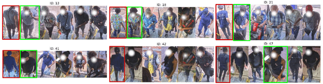
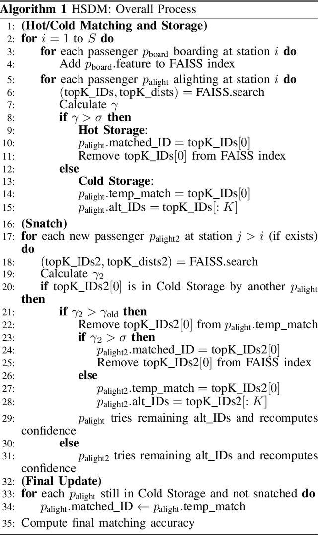
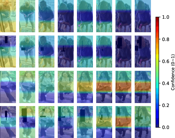
Transit Origin-Destination (OD) data are essential for transit planning, particularly in route optimization and demand-responsive paratransit systems. Traditional methods, such as manual surveys, are costly and inefficient, while Bluetooth and WiFi-based approaches require passengers to carry specific devices, limiting data coverage. On the other hand, most transit vehicles are equipped with onboard cameras for surveillance, offering an opportunity to repurpose them for edge-based OD data collection through visual person re-identification (ReID). However, such approaches face significant challenges, including severe occlusion and viewpoint variations in transit environments, which greatly reduce matching accuracy and hinder their adoption. Moreover, designing effective algorithms that can operate efficiently on edge devices remains an open challenge. To address these challenges, we propose TransitReID, a novel framework for individual-level transit OD data collection. TransitReID consists of two key components: (1) An occlusion-robust ReID algorithm featuring a variational autoencoder guided region-attention mechanism that adaptively focuses on visible body regions through reconstruction loss-optimized weight allocation; and (2) a Hierarchical Storage and Dynamic Matching (HSDM) mechanism specifically designed for efficient and robust transit OD matching which balances storage, speed, and accuracy. Additionally, a multi-threaded design supports near real-time operation on edge devices, which also ensuring privacy protection. We also introduce a ReID dataset tailored for complex bus environments to address the lack of relevant training data. Experimental results demonstrate that TransitReID achieves state-of-the-art performance in ReID tasks, with an accuracy of approximately 90\% in bus route simulations.
Enhancing Disaster Resilience with UAV-Assisted Edge Computing: A Reinforcement Learning Approach to Managing Heterogeneous Edge Devices
Jan 25, 2025Edge sensing and computing is rapidly becoming part of intelligent infrastructure architecture leading to operational reliance on such systems in disaster or emergency situations. In such scenarios there is a high chance of power supply failure due to power grid issues, and communication system issues due to base stations losing power or being damaged by the elements, e.g., flooding, wildfires etc. Mobile edge computing in the form of unmanned aerial vehicles (UAVs) has been proposed to provide computation offloading from these devices to conserve their battery, while the use of UAVs as relay network nodes has also been investigated previously. This paper considers the use of UAVs with further constraints on power and connectivity to prolong the life of the network while also ensuring that the data is received from the edge nodes in a timely manner. Reinforcement learning is used to investigate numerous scenarios of various levels of power and communication failure. This approach is able to identify the device most likely to fail in a given scenario, thus providing priority guidance for maintenance personnel. The evacuations of a rural town and urban downtown area are also simulated to demonstrate the effectiveness of the approach at extending the life of the most critical edge devices.
Traffic Co-Simulation Framework Empowered by Infrastructure Camera Sensing and Reinforcement Learning
Dec 05, 2024Traffic simulations are commonly used to optimize traffic flow, with reinforcement learning (RL) showing promising potential for automated traffic signal control. Multi-agent reinforcement learning (MARL) is particularly effective for learning control strategies for traffic lights in a network using iterative simulations. However, existing methods often assume perfect vehicle detection, which overlooks real-world limitations related to infrastructure availability and sensor reliability. This study proposes a co-simulation framework integrating CARLA and SUMO, which combines high-fidelity 3D modeling with large-scale traffic flow simulation. Cameras mounted on traffic light poles within the CARLA environment use a YOLO-based computer vision system to detect and count vehicles, providing real-time traffic data as input for adaptive signal control in SUMO. MARL agents, trained with four different reward structures, leverage this visual feedback to optimize signal timings and improve network-wide traffic flow. Experiments in the test-bed demonstrate the effectiveness of the proposed MARL approach in enhancing traffic conditions using real-time camera-based detection. The framework also evaluates the robustness of MARL under faulty or sparse sensing and compares the performance of YOLOv5 and YOLOv8 for vehicle detection. Results show that while better accuracy improves performance, MARL agents can still achieve significant improvements with imperfect detection, demonstrating adaptability for real-world scenarios.
Deep Learning based Computer Vision Methods for Complex Traffic Environments Perception: A Review
Nov 09, 2022Computer vision applications in intelligent transportation systems (ITS) and autonomous driving (AD) have gravitated towards deep neural network architectures in recent years. While performance seems to be improving on benchmark datasets, many real-world challenges are yet to be adequately considered in research. This paper conducted an extensive literature review on the applications of computer vision in ITS and AD, and discusses challenges related to data, models, and complex urban environments. The data challenges are associated with the collection and labeling of training data and its relevance to real world conditions, bias inherent in datasets, the high volume of data needed to be processed, and privacy concerns. Deep learning (DL) models are commonly too complex for real-time processing on embedded hardware, lack explainability and generalizability, and are hard to test in real-world settings. Complex urban traffic environments have irregular lighting and occlusions, and surveillance cameras can be mounted at a variety of angles, gather dirt, shake in the wind, while the traffic conditions are highly heterogeneous, with violation of rules and complex interactions in crowded scenarios. Some representative applications that suffer from these problems are traffic flow estimation, congestion detection, autonomous driving perception, vehicle interaction, and edge computing for practical deployment. The possible ways of dealing with the challenges are also explored while prioritizing practical deployment.