 Add to Chrome
 Add to Firefox
 Add to Edge
Improving Map Consistency in Graph-Based LiDAR SLAM Through Information-Aware Odometry and Retroactive Loop Closure
Jul 15, 2026
High-quality maps are fundamental for robotics tasks such as navigation and planning. Although modern graph-based LiDAR SLAM systems achieve good trajectory accuracies, a low trajectory error alone does not guarantee geometrically consistent maps, particularly at revisit locations where missed loop closures and residual drift can produce local misalignments. In this work, we address the problem of jointly improving global trajectory estimation and local map quality in 3D LiDAR SLAM. We first propose a framework to efficiently estimate geometry-dependent information matrices for ICP, enabling principled weighting of odometry constraints in a pose graph. We then introduce a hierarchical loop-closure module that decouples place recognition from geometric registration, together with a retroactive loop-closure module that exploits the optimized pose graph to recover missed loop closures. We also propose an evaluation protocol to measure map consistency at revisit locations. We evaluate our SLAM system on several datasets against state-of-the-art LiDAR SLAM systems. Experimental results demonstrate global trajectory accuracies on par with or better than existing methods while consistently improving local geometric map consistency at revisit locations. These results suggest that coupling uncertainty-aware odometry with geometry-guided loop-closure refinement leads to more accurate trajectories and higher-quality maps.

Efficiently Closing Loops in LiDAR-Based SLAM Using Point Cloud Density Maps
Jan 13, 2025
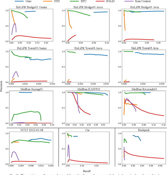
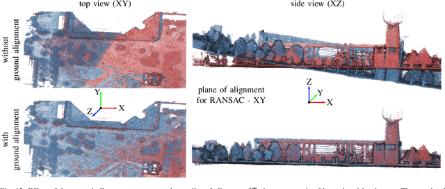
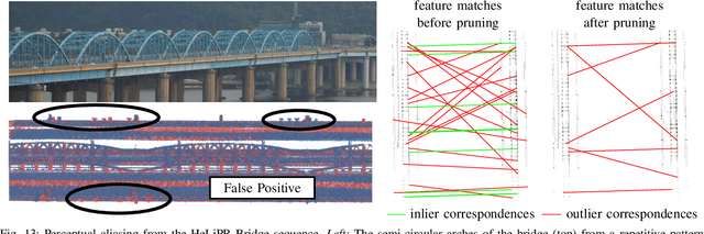
Consistent maps are key for most autonomous mobile robots. They often use SLAM approaches to build such maps. Loop closures via place recognition help maintain accurate pose estimates by mitigating global drift. This paper presents a robust loop closure detection pipeline for outdoor SLAM with LiDAR-equipped robots. The method handles various LiDAR sensors with different scanning patterns, field of views and resolutions. It generates local maps from LiDAR scans and aligns them using a ground alignment module to handle both planar and non-planar motion of the LiDAR, ensuring applicability across platforms. The method uses density-preserving bird's eye view projections of these local maps and extracts ORB feature descriptors from them for place recognition. It stores the feature descriptors in a binary search tree for efficient retrieval, and self-similarity pruning addresses perceptual aliasing in repetitive environments. Extensive experiments on public and self-recorded datasets demonstrate accurate loop closure detection, long-term localization, and cross-platform multi-map alignment, agnostic to the LiDAR scanning patterns, fields of view, and motion profiles.