 Add to Chrome
 Add to Firefox
 Add to Edge
Flying to Image-Specified Objects: 3D Quadrotor Navigation via Cross-Graph Memory and Viewpoint Planning
Jun 29, 2026
Instance-Specific Image-Goal Navigation (InstanceImageNav) requires a robot to navigate toward the exact object instance depicted in a query image. Extending this task to quadrotors is challenging due to continuous 3D control, limited field of view (FOV), and safety constraints, which make successful navigation highly dependent on selecting informative viewpoints. We propose a hierarchical navigation framework for quadrotor InstanceImageNav that separates high-level decision making from low-level motion execution. Instead of navigating directly to spatial locations, the system generates viewpoint-aware action nodes around frontier regions and potential target objects, enabling the robot to explore while maintaining informative viewpoints for detecting the target instance. A lightweight semantic memory maintains object-level and observation-level context, allowing semantic cues to propagate to candidate action nodes for decision making. A learning-based policy selects the most promising action node, and a trajectory planner generates dynamically feasible 3D flight paths for safe execution. Experiments in simulation demonstrate consistent improvements over strong baselines, and real-world quadrotor flights validate the practicality and robustness of the proposed framework.

RoamFlow: Reinforcement-Aligned One-Step Action MeanFlow Policy for Image-Goal Navigation
Jun 29, 2026Image-goal navigation is a key challenge in embodied robotics, where an agent must reach a target specified solely by a goal image. While existing reinforcement learning approaches map perceptual observations directly to actions, they struggle to model long-horizon dependencies, often leading to suboptimal trajectories. To address this limitation, we propose RoamFlow, a generative navigation framework that leverages MeanFlow to predict the average velocity field for trajectory synthesis, enabling efficient few-step generation and reducing inference latency. We further adopt a two-stage training strategy that combines expert imitation for stable initialization with reinforcement learning for task-specific policy refinement. Extensive experiments in both Habitat simulation and real-world robotic platforms demonstrate that RoamFlow achieves efficient inference while maintaining strong navigation performance under real-time constraints.
GaussFly: Contrastive Reinforcement Learning for Visuomotor Policies in 3D Gaussian Fields
Apr 06, 2026Learning visuomotor policies for Autonomous Aerial Vehicles (AAVs) relying solely on monocular vision is an attractive yet highly challenging paradigm. Existing end-to-end learning approaches directly map high-dimensional RGB observations to action commands, which frequently suffer from low sample efficiency and severe sim-to-real gaps due to the visual discrepancy between simulation and physical domains. To address these long-standing challenges, we propose GaussFly, a novel framework that explicitly decouples representation learning from policy optimization through a cohesive real-to-sim-to-real paradigm. First, to achieve a high-fidelity real-to-sim transition, we reconstruct training scenes using 3D Gaussian Splatting (3DGS) augmented with explicit geometric constraints. Second, to ensure robust sim-to-real transfer, we leverage these photorealistic simulated environments and employ contrastive representation learning to extract compact, noise-resilient latent features from the rendered RGB images. By utilizing this pre-trained encoder to provide low-dimensional feature inputs, the computational burden on the visuomotor policy is significantly reduced while its resistance against visual noise is inherently enhanced. Extensive experiments in simulated and real-world environments demonstrate that GaussFly achieves superior sample efficiency and asymptotic performance compared to baselines. Crucially, it enables robust and zero-shot policy transfer to unseen real-world environments with complex textures, effectively bridging the sim-to-real gap.
Dual-Stage Invariant Continual Learning under Extreme Visual Sparsity
Mar 27, 2026Continual learning seeks to maintain stable adaptation under non-stationary environments, yet this problem becomes particularly challenging in object detection, where most existing methods implicitly assume relatively balanced visual conditions. In extreme-sparsity regimes, such as those observed in space-based resident space object (RSO) detection scenarios, foreground signals are overwhelmingly dominated by background observations. Under such conditions, we analytically demonstrate that background-driven gradients destabilize the feature backbone during sequential domain shifts, causing progressive representation drift. This exposes a structural limitation of continual learning approaches relying solely on output-level distillation, as they fail to preserve intermediate representation stability. To address this, we propose a dual-stage invariant continual learning framework via joint distillation, enforcing structural and semantic consistency on both backbone representations and detection predictions, respectively, thereby suppressing error propagation at its source while maintaining adaptability. Furthermore, to regulate gradient statistics under severe imbalance, we introduce a sparsity-aware data conditioning strategy combining patch-based sampling and distribution-aware augmentation. Experiments on a high-resolution space-based RSO detection dataset show consistent improvement over established continual object detection methods, achieving an absolute gain of +4.0 mAP under sequential domain shifts.
Learning Adaptive Cross-Embodiment Visuomotor Policy with Contrastive Prompt Orchestration
Feb 01, 2026Learning adaptive visuomotor policies for embodied agents remains a formidable challenge, particularly when facing cross-embodiment variations such as diverse sensor configurations and dynamic properties. Conventional learning approaches often struggle to separate task-relevant features from domain-specific variations (e.g., lighting, field-of-view, and rotation), leading to poor sample efficiency and catastrophic failure in unseen environments. To bridge this gap, we propose ContrAstive Prompt Orchestration (CAPO), a novel approach for learning visuomotor policies that integrates contrastive prompt learning and adaptive prompt orchestration. For prompt learning, we devise a hybrid contrastive learning strategy that integrates visual, temporal action, and text objectives to establish a pool of learnable prompts, where each prompt induces a visual representation encapsulating fine-grained domain factors. Based on these learned prompts, we introduce an adaptive prompt orchestration mechanism that dynamically aggregates these prompts conditioned on current observations. This enables the agent to adaptively construct optimal state representations by identifying dominant domain factors instantaneously. Consequently, the policy optimization is effectively shielded from irrelevant interference, preventing the common issue of overfitting to source domains. Extensive experiments demonstrate that CAPO significantly outperforms state-of-the-art baselines in sample efficiency and asymptotic performance. Crucially, it exhibits superior zero-shot adaptation across unseen target domains characterized by drastic environmental (e.g., illumination) and physical shifts (e.g., field-of-view and rotation), validating its effectiveness as a viable solution for cross-embodiment visuomotor policy adaptation.
Grounded Vision-Language Navigation for UAVs with Open-Vocabulary Goal Understanding
Jun 12, 2025Vision-and-language navigation (VLN) is a long-standing challenge in autonomous robotics, aiming to empower agents with the ability to follow human instructions while navigating complex environments. Two key bottlenecks remain in this field: generalization to out-of-distribution environments and reliance on fixed discrete action spaces. To address these challenges, we propose Vision-Language Fly (VLFly), a framework tailored for Unmanned Aerial Vehicles (UAVs) to execute language-guided flight. Without the requirement for localization or active ranging sensors, VLFly outputs continuous velocity commands purely from egocentric observations captured by an onboard monocular camera. The VLFly integrates three modules: an instruction encoder based on a large language model (LLM) that reformulates high-level language into structured prompts, a goal retriever powered by a vision-language model (VLM) that matches these prompts to goal images via vision-language similarity, and a waypoint planner that generates executable trajectories for real-time UAV control. VLFly is evaluated across diverse simulation environments without additional fine-tuning and consistently outperforms all baselines. Moreover, real-world VLN tasks in indoor and outdoor environments under direct and indirect instructions demonstrate that VLFly achieves robust open-vocabulary goal understanding and generalized navigation capabilities, even in the presence of abstract language input.
FM-Planner: Foundation Model Guided Path Planning for Autonomous Drone Navigation
May 27, 2025Path planning is a critical component in autonomous drone operations, enabling safe and efficient navigation through complex environments. Recent advances in foundation models, particularly large language models (LLMs) and vision-language models (VLMs), have opened new opportunities for enhanced perception and intelligent decision-making in robotics. However, their practical applicability and effectiveness in global path planning remain relatively unexplored. This paper proposes foundation model-guided path planners (FM-Planner) and presents a comprehensive benchmarking study and practical validation for drone path planning. Specifically, we first systematically evaluate eight representative LLM and VLM approaches using standardized simulation scenarios. To enable effective real-time navigation, we then design an integrated LLM-Vision planner that combines semantic reasoning with visual perception. Furthermore, we deploy and validate the proposed path planner through real-world experiments under multiple configurations. Our findings provide valuable insights into the strengths, limitations, and feasibility of deploying foundation models in real-world drone applications and providing practical implementations in autonomous flight. Project site: https://github.com/NTU-ICG/FM-Planner.
SaViD: Spectravista Aesthetic Vision Integration for Robust and Discerning 3D Object Detection in Challenging Environments
Mar 26, 2025
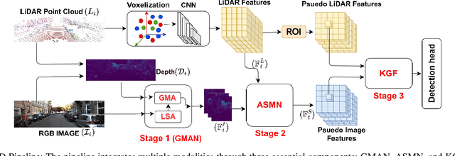
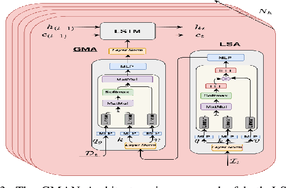
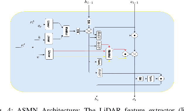
The fusion of LiDAR and camera sensors has demonstrated significant effectiveness in achieving accurate detection for short-range tasks in autonomous driving. However, this fusion approach could face challenges when dealing with long-range detection scenarios due to disparity between sparsity of LiDAR and high-resolution camera data. Moreover, sensor corruption introduces complexities that affect the ability to maintain robustness, despite the growing adoption of sensor fusion in this domain. We present SaViD, a novel framework comprised of a three-stage fusion alignment mechanism designed to address long-range detection challenges in the presence of natural corruption. The SaViD framework consists of three key elements: the Global Memory Attention Network (GMAN), which enhances the extraction of image features through offering a deeper understanding of global patterns; the Attentional Sparse Memory Network (ASMN), which enhances the integration of LiDAR and image features; and the KNNnectivity Graph Fusion (KGF), which enables the entire fusion of spatial information. SaViD achieves superior performance on the long-range detection Argoverse-2 (AV2) dataset with a performance improvement of 9.87% in AP value and an improvement of 2.39% in mAPH for L2 difficulties on the Waymo Open dataset (WOD). Comprehensive experiments are carried out to showcase its robustness against 14 natural sensor corruptions. SaViD exhibits a robust performance improvement of 31.43% for AV2 and 16.13% for WOD in RCE value compared to other existing fusion-based methods while considering all the corruptions for both datasets. Our code is available at \href{https://github.com/sanjay-810/SAVID}
Learning Resilient Formation Control of Drones with Graph Attention Network
Sep 03, 2024The rapid advancement of drone technology has significantly impacted various sectors, including search and rescue, environmental surveillance, and industrial inspection. Multidrone systems offer notable advantages such as enhanced efficiency, scalability, and redundancy over single-drone operations. Despite these benefits, ensuring resilient formation control in dynamic and adversarial environments, such as under communication loss or cyberattacks, remains a significant challenge. Classical approaches to resilient formation control, while effective in certain scenarios, often struggle with complex modeling and the curse of dimensionality, particularly as the number of agents increases. This paper proposes a novel, learning-based formation control for enhancing the adaptability and resilience of multidrone formations using graph attention networks (GATs). By leveraging GAT's dynamic capabilities to extract internode relationships based on the attention mechanism, this GAT-based formation controller significantly improves the robustness of drone formations against various threats, such as Denial of Service (DoS) attacks. Our approach not only improves formation performance in normal conditions but also ensures the resilience of multidrone systems in variable and adversarial environments. Extensive simulation results demonstrate the superior performance of our method over baseline formation controllers. Furthermore, the physical experiments validate the effectiveness of the trained control policy in real-world flights.
Clustering-based Learning for UAV Tracking and Pose Estimation
May 27, 2024UAV tracking and pose estimation plays an imperative role in various UAV-related missions, such as formation control and anti-UAV measures. Accurately detecting and tracking UAVs in a 3D space remains a particularly challenging problem, as it requires extracting sparse features of micro UAVs from different flight environments and continuously matching correspondences, especially during agile flight. Generally, cameras and LiDARs are the two main types of sensors used to capture UAV trajectories in flight. However, both sensors have limitations in UAV classification and pose estimation. This technical report briefly introduces the method proposed by our team "NTU-ICG" for the CVPR 2024 UG2+ Challenge Track 5. This work develops a clustering-based learning detection approach, CL-Det, for UAV tracking and pose estimation using two types of LiDARs, namely Livox Avia and LiDAR 360. We combine the information from the two data sources to locate drones in 3D. We first align the timestamps of Livox Avia data and LiDAR 360 data and then separate the point cloud of objects of interest (OOIs) from the environment. The point cloud of OOIs is clustered using the DBSCAN method, with the midpoint of the largest cluster assumed to be the UAV position. Furthermore, we utilize historical estimations to fill in missing data. The proposed method shows competitive pose estimation performance and ranks 5th on the final leaderboard of the CVPR 2024 UG2+ Challenge.