 Add to Chrome
 Add to Firefox
 Add to Edge
Bringing Agentic Search to Earth Observation Data Discovery
Jul 02, 2026
NASA and its data centers hold thousands of geoscience datasets and tools like Worldview, Giovanni, the Science Discovery Engine, and Harmony. Finding the right one is hard even for domain experts. We present an agentic search system, deployed as a public service for the geoscience community, that takes a natural-language research query and returns the matching datasets and tools. We demonstrate that, in the era of large language models, the latent value of knowledge graphs (KGs) can be substantially amplified through agentic search. From the NASA Earth Observation Knowledge Graph (NASA EO-KG) we derive NASA-EO-Bench, an open benchmark of 47k query-dataset pairs (21k task-based queries). A neural scorer fine-tuned on NASA-EO-Bench beats cosine and BM25 baselines. Further combining it with BM25 via score fusion raises both Recall@10 (R@10) and MRR by over 5x. On top of this supervised pipeline, we add a zero-shot agentic reranking stage that, without any additional training, lifts MRR by 28% on a stratified N=200 subset, showing that LLM reasoning is complementary to supervised retrieval.

Efficient Kilometer-Scale Precipitation Downscaling with Conditional Wavelet Diffusion
Jul 02, 2025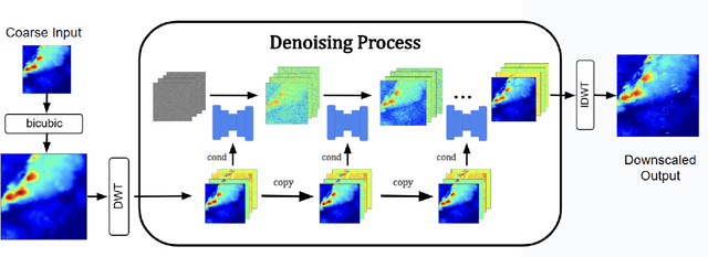
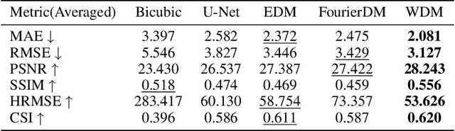
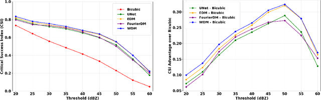
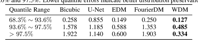
Effective hydrological modeling and extreme weather analysis demand precipitation data at a kilometer-scale resolution, which is significantly finer than the 10 km scale offered by standard global products like IMERG. To address this, we propose the Wavelet Diffusion Model (WDM), a generative framework that achieves 10x spatial super-resolution (downscaling to 1 km) and delivers a 9x inference speedup over pixel-based diffusion models. WDM is a conditional diffusion model that learns the learns the complex structure of precipitation from MRMS radar data directly in the wavelet domain. By focusing on high-frequency wavelet coefficients, it generates exceptionally realistic and detailed 1-km precipitation fields. This wavelet-based approach produces visually superior results with fewer artifacts than pixel-space models, and delivers a significant gains in sampling efficiency. Our results demonstrate that WDM provides a robust solution to the dual challenges of accuracy and speed in geoscience super-resolution, paving the way for more reliable hydrological forecasts.