 Add to Chrome
 Add to Firefox
 Add to Edge
UAV3DCrop: Benchmarking 3D Reconstruction in Repeated Multi-Angle UAV Crop Surveys
Aug 03, 2026
Accurate 3D crop monitoring underpins data-driven precision agriculture by enabling field-scale analysis of plant structure, growth dynamics, and management response. Modern 3D reconstruction methods perform strongly on generic benchmarks, but rendered appearance may not translate into metrically and agronomically useful geometry in crop fields. We introduce UAV3DCrop, a public benchmark of repeated multi-angle unmanned aerial vehicle (UAV) crop surveys. It contains 88,830 RGB images at $5280 \times 3956$ pixels, with a ground sampling distance of 3.6-5.8 mm, from 91 scenes spanning corn, soybean, wheat, and oat. Track A evaluates seven scene-optimized methods -- Neural Radiance Field (NeRF) and 3D Gaussian Splatting (3DGS) variants -- on held-out views, photogrammetry-referenced depth, and canopy-height recovery. Track B tests four pretrained feed-forward models on zero-shot camera-pose and geometry estimation. The scene-optimized methods rank differently across the three targets: Splatfacto-big leads appearance, whereas Scaffold-GS leads depth and is statistically tied with Splatfacto for canopy height. Among feed-forward models, MapAnything leads on seven of the eight metrics, while the remaining models vary more across crops and fail severely on absolute scale in a way that alignment conceals. Repeated acquisitions reveal further sensitivities that differ by output type and by model, associated with position within the acquisition sequence and with tie-point multiplicity. Current 3D reconstruction methods are therefore not yet interchangeable for agronomic use: no single method wins on appearance, geometry, and canopy height at once, and only one of four feed-forward models recovers usable metric scale. The dataset is publicly available at https://link-dev.github.io/UAV3DCrop/

Mapping smallholder cashew plantations to inform sustainable tree crop expansion in Benin
Jan 01, 2023

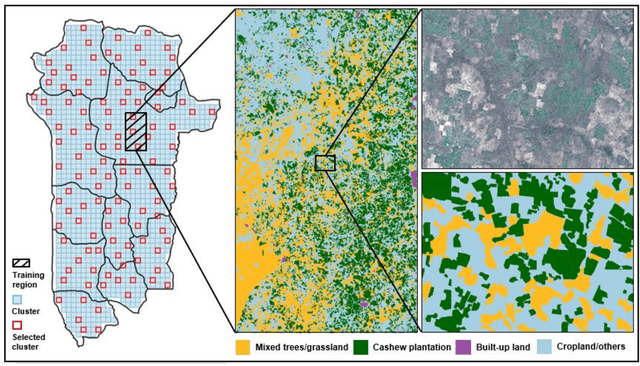

Cashews are grown by over 3 million smallholders in more than 40 countries worldwide as a principal source of income. As the third largest cashew producer in Africa, Benin has nearly 200,000 smallholder cashew growers contributing 15% of the country's national export earnings. However, a lack of information on where and how cashew trees grow across the country hinders decision-making that could support increased cashew production and poverty alleviation. By leveraging 2.4-m Planet Basemaps and 0.5-m aerial imagery, newly developed deep learning algorithms, and large-scale ground truth datasets, we successfully produced the first national map of cashew in Benin and characterized the expansion of cashew plantations between 2015 and 2021. In particular, we developed a SpatioTemporal Classification with Attention (STCA) model to map the distribution of cashew plantations, which can fully capture texture information from discriminative time steps during a growing season. We further developed a Clustering Augmented Self-supervised Temporal Classification (CASTC) model to distinguish high-density versus low-density cashew plantations by automatic feature extraction and optimized clustering. Results show that the STCA model has an overall accuracy of 80% and the CASTC model achieved an overall accuracy of 77.9%. We found that the cashew area in Benin has doubled from 2015 to 2021 with 60% of new plantation development coming from cropland or fallow land, while encroachment of cashew plantations into protected areas has increased by 70%. Only half of cashew plantations were high-density in 2021, suggesting high potential for intensification. Our study illustrates the power of combining high-resolution remote sensing imagery and state-of-the-art deep learning algorithms to better understand tree crops in the heterogeneous smallholder landscape.