 Add to Chrome
 Add to Firefox
 Add to Edge
Mapping Reduced Accessibility to WASH Facilities in Rohingya Refugee Camps With Sub-Meter Imagery
Nov 18, 2025Access to Water, Sanitation, and Hygiene (WASH) services remains a major public health concern in refugee camps. This study introduces a remote sensing-driven framework to quantify WASH accessibility-specifically to water pumps, latrines, and bathing cubicles-in the Rohingya camps of Cox's Bazar, one of the world's most densely populated displacement settings. Detecting refugee shelters in such emergent camps presents substantial challenges, primarily due to their dense spatial configuration and irregular geometric patterns. Using sub-meter satellite images, we develop a semi-supervised segmentation framework that achieves an F1-score of 76.4% in detecting individual refugee shelters. Applying the framework across multi-year data reveals declining WASH accessibility, driven by rapid refugee population growth and reduced facility availability, rising from 25 people per facility in 2022 to 29.4 in 2025. Gender-disaggregated analysis further shows that women and girls experience reduced accessibility, in scenarios with inadequate safety-related segregation in WASH facilities. These findings suggest the importance of demand-responsive allocation strategies that can identify areas with under-served populations-such as women and girls-and ensure that limited infrastructure serves the greatest number of people in settings with fixed or shrinking budgets. We also discuss the value of high-resolution remote sensing and machine learning to detect inequality and inform equitable resource planning in complex humanitarian environments.
Generalizable Slum Detection from Satellite Imagery with Mixture-of-Experts
Nov 13, 2025Satellite-based slum segmentation holds significant promise in generating global estimates of urban poverty. However, the morphological heterogeneity of informal settlements presents a major challenge, hindering the ability of models trained on specific regions to generalize effectively to unseen locations. To address this, we introduce a large-scale high-resolution dataset and propose GRAM (Generalized Region-Aware Mixture-of-Experts), a two-phase test-time adaptation framework that enables robust slum segmentation without requiring labeled data from target regions. We compile a million-scale satellite imagery dataset from 12 cities across four continents for source training. Using this dataset, the model employs a Mixture-of-Experts architecture to capture region-specific slum characteristics while learning universal features through a shared backbone. During adaptation, prediction consistency across experts filters out unreliable pseudo-labels, allowing the model to generalize effectively to previously unseen regions. GRAM outperforms state-of-the-art baselines in low-resource settings such as African cities, offering a scalable and label-efficient solution for global slum mapping and data-driven urban planning.
Lightweight and Robust Representation of Economic Scales from Satellite Imagery
Dec 18, 2019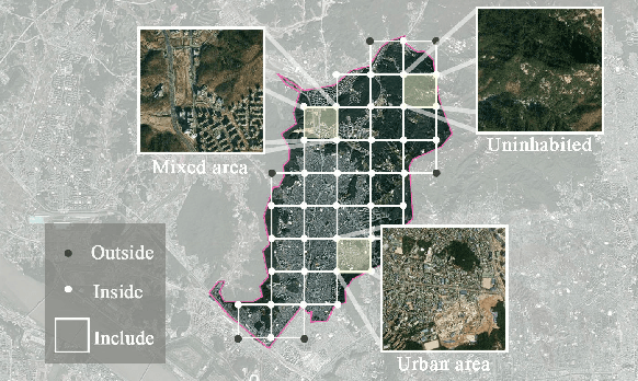
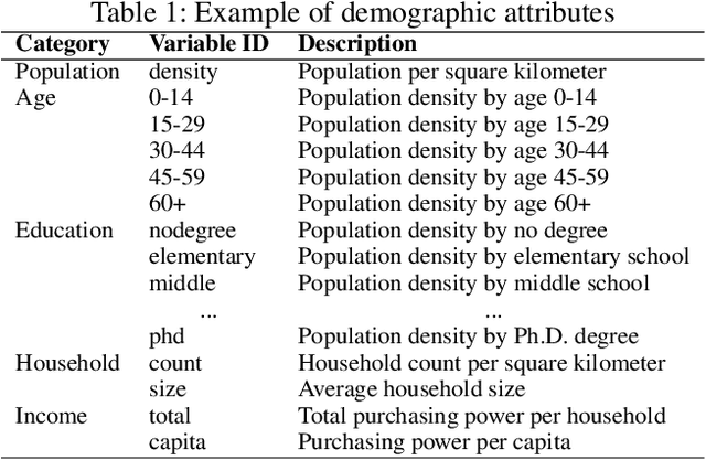
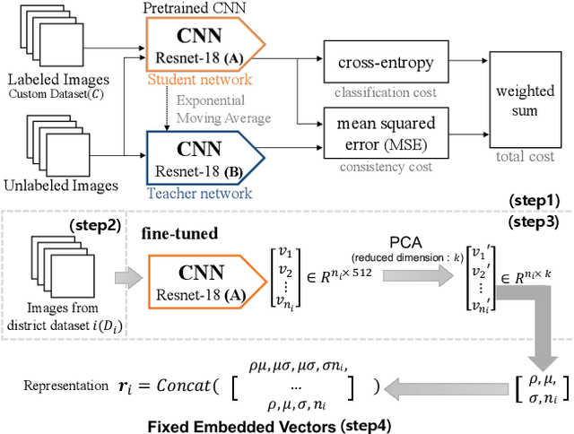
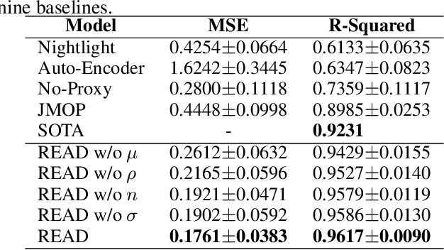
Satellite imagery has long been an attractive data source that provides a wealth of information on human-inhabited areas. While super resolution satellite images are rapidly becoming available, little study has focused on how to extract meaningful information about human habitation patterns and economic scales from such data. We present READ, a new approach for obtaining essential spatial representation for any given district from high-resolution satellite imagery based on deep neural networks. Our method combines transfer learning and embedded statistics to efficiently learn critical spatial characteristics of arbitrary size areas and represent them into a fixed-length vector with minimal information loss. Even with a small set of labels, READ can distinguish subtle differences between rural and urban areas and infer the degree of urbanization. An extensive evaluation demonstrates the model outperforms the state-of-the-art in predicting economic scales, such as population density for South Korea (R^2=0.9617), and shows a high potential use for developing countries where district-level economic scales are not known.