 Add to Chrome
 Add to Firefox
 Add to Edge
BuildMamba: A Visual State-Space Based Model for Multi-Task Building Segmentation and Height Estimation from Satellite Images
Mar 09, 2026Accurate building segmentation and height estimation from single-view RGB satellite imagery are fundamental for urban analytics, yet remain ill-posed due to structural variability and the high computational cost of global context modeling. While current approaches typically adapt monocular depth architectures, they often suffer from boundary bleeding and systematic underestimation of high-rise structures. To address these limitations, we propose BuildMamba, a unified multi-task framework designed to exploit the linear-time global modeling of visual state-space models. Motivated by the need for stronger structural coupling and computational efficiency, we introduce three modules: a Mamba Attention Module for dynamic spatial recalibration, a Spatial-Aware Mamba-FPN for multi-scale feature aggregation via gated state-space scans, and a Mask-Aware Height Refinement module using semantic priors to suppress height artifacts. Extensive experiments demonstrate that BuildMamba establishes a new performance upper bound across three benchmarks. Specifically, it achieves an IoU of 0.93 and RMSE of 1.77~m on DFC23 benchmark, surpassing state-of-the-art by 0.82~m in height estimation. Simulation results confirm the model's superior robustness and scalability for large-scale 3D urban reconstruction.
VLMFusionOcc3D: VLM Assisted Multi-Modal 3D Semantic Occupancy Prediction
Mar 03, 2026This paper introduces VLMFusionOcc3D, a robust multimodal framework for dense 3D semantic occupancy prediction in autonomous driving. Current voxel-based occupancy models often struggle with semantic ambiguity in sparse geometric grids and performance degradation under adverse weather conditions. To address these challenges, we leverage the rich linguistic priors of Vision-Language Models (VLMs) to anchor ambiguous voxel features to stable semantic concepts. Our framework initiates with a dual-branch feature extraction pipeline that projects multi-view images and LiDAR point clouds into a unified voxel space. We propose Instance-driven VLM Attention (InstVLM), which utilizes gated cross-attention and LoRA-adapted CLIP embeddings to inject high-level semantic and geographic priors directly into the 3D voxels. Furthermore, we introduce Weather-Aware Adaptive Fusion (WeathFusion), a dynamic gating mechanism that utilizes vehicle metadata and weather-conditioned prompts to re-weight sensor contributions based on real-time environmental reliability. To ensure structural consistency, a Depth-Aware Geometric Alignment (DAGA) loss is employed to align dense camera-derived geometry with sparse, spatially accurate LiDAR returns. Extensive experiments on the nuScenes and SemanticKITTI datasets demonstrate that our plug-and-play modules consistently enhance the performance of state-of-the-art voxel-based baselines. Notably, our approach achieves significant improvements in challenging weather scenarios, offering a scalable and robust solution for complex urban navigation.
GaussianOcc3D: A Gaussian-Based Adaptive Multi-modal 3D Occupancy Prediction
Jan 30, 20263D semantic occupancy prediction is a pivotal task in autonomous driving, providing a dense and fine-grained understanding of the surrounding environment, yet single-modality methods face trade-offs between camera semantics and LiDAR geometry. Existing multi-modal frameworks often struggle with modality heterogeneity, spatial misalignment, and the representation crisis--where voxels are computationally heavy and BEV alternatives are lossy. We present GaussianOcc3D, a multi-modal framework bridging camera and LiDAR through a memory-efficient, continuous 3D Gaussian representation. We introduce four modules: (1) LiDAR Depth Feature Aggregation (LDFA), using depth-wise deformable sampling to lift sparse signals onto Gaussian primitives; (2) Entropy-Based Feature Smoothing (EBFS) to mitigate domain noise; (3) Adaptive Camera-LiDAR Fusion (ACLF) with uncertainty-aware reweighting for sensor reliability; and (4) a Gauss-Mamba Head leveraging Selective State Space Models for global context with linear complexity. Evaluations on Occ3D, SurroundOcc, and SemanticKITTI benchmarks demonstrate state-of-the-art performance, achieving mIoU scores of 49.4%, 28.9%, and 25.2% respectively. GaussianOcc3D exhibits superior robustness across challenging rainy and nighttime conditions.
X2BR: High-Fidelity 3D Bone Reconstruction from a Planar X-Ray Image with Hybrid Neural Implicit Methods
Apr 11, 2025


Accurate 3D bone reconstruction from a single planar X-ray remains a challenge due to anatomical complexity and limited input data. We propose X2BR, a hybrid neural implicit framework that combines continuous volumetric reconstruction with template-guided non-rigid registration. The core network, X2B, employs a ConvNeXt-based encoder to extract spatial features from X-rays and predict high-fidelity 3D bone occupancy fields without relying on statistical shape models. To further refine anatomical accuracy, X2BR integrates a patient-specific template mesh, constructed using YOLOv9-based detection and the SKEL biomechanical skeleton model. The coarse reconstruction is aligned to the template using geodesic-based coherent point drift, enabling anatomically consistent 3D bone volumes. Experimental results on a clinical dataset show that X2B achieves the highest numerical accuracy, with an IoU of 0.952 and Chamfer-L1 distance of 0.005, outperforming recent baselines including X2V and D2IM-Net. Building on this, X2BR incorporates anatomical priors via YOLOv9-based bone detection and biomechanical template alignment, leading to reconstructions that, while slightly lower in IoU (0.875), offer superior anatomical realism, especially in rib curvature and vertebral alignment. This numerical accuracy vs. visual consistency trade-off between X2B and X2BR highlights the value of hybrid frameworks for clinically relevant 3D reconstructions.
TransAdapter: Vision Transformer for Feature-Centric Unsupervised Domain Adaptation
Dec 05, 2024


Unsupervised Domain Adaptation (UDA) aims to utilize labeled data from a source domain to solve tasks in an unlabeled target domain, often hindered by significant domain gaps. Traditional CNN-based methods struggle to fully capture complex domain relationships, motivating the shift to vision transformers like the Swin Transformer, which excel in modeling both local and global dependencies. In this work, we propose a novel UDA approach leveraging the Swin Transformer with three key modules. A Graph Domain Discriminator enhances domain alignment by capturing inter-pixel correlations through graph convolutions and entropy-based attention differentiation. An Adaptive Double Attention module combines Windows and Shifted Windows attention with dynamic reweighting to align long-range and local features effectively. Finally, a Cross-Feature Transform modifies Swin Transformer blocks to improve generalization across domains. Extensive benchmarks confirm the state-of-the-art performance of our versatile method, which requires no task-specific alignment modules, establishing its adaptability to diverse applications.
XPoint: A Self-Supervised Visual-State-Space based Architecture for Multispectral Image Registration
Nov 11, 2024


Accurate multispectral image matching presents significant challenges due to non-linear intensity variations across spectral modalities, extreme viewpoint changes, and the scarcity of labeled datasets. Current state-of-the-art methods are typically specialized for a single spectral difference, such as visibleinfrared, and struggle to adapt to other modalities due to their reliance on expensive supervision, such as depth maps or camera poses. To address the need for rapid adaptation across modalities, we introduce XPoint, a self-supervised, modular image-matching framework designed for adaptive training and fine-tuning on aligned multispectral datasets, allowing users to customize key components based on their specific tasks. XPoint employs modularity and self-supervision to allow for the adjustment of elements such as the base detector, which generates pseudoground truth keypoints invariant to viewpoint and spectrum variations. The framework integrates a VMamba encoder, pretrained on segmentation tasks, for robust feature extraction, and includes three joint decoder heads: two are dedicated to interest point and descriptor extraction; and a task-specific homography regression head imposes geometric constraints for superior performance in tasks like image registration. This flexible architecture enables quick adaptation to a wide range of modalities, demonstrated by training on Optical-Thermal data and fine-tuning on settings such as visual-near infrared, visual-infrared, visual-longwave infrared, and visual-synthetic aperture radar. Experimental results show that XPoint consistently outperforms or matches state-ofthe-art methods in feature matching and image registration tasks across five distinct multispectral datasets. Our source code is available at https://github.com/canyagmur/XPoint.
Deep learning-based blind image super-resolution with iterative kernel reconstruction and noise estimation
Apr 25, 2024


Blind single image super-resolution (SISR) is a challenging task in image processing due to the ill-posed nature of the inverse problem. Complex degradations present in real life images make it difficult to solve this problem using na\"ive deep learning approaches, where models are often trained on synthetically generated image pairs. Most of the effort so far has been focused on solving the inverse problem under some constraints, such as for a limited space of blur kernels and/or assuming noise-free input images. Yet, there is a gap in the literature to provide a well-generalized deep learning-based solution that performs well on images with unknown and highly complex degradations. In this paper, we propose IKR-Net (Iterative Kernel Reconstruction Network) for blind SISR. In the proposed approach, kernel and noise estimation and high-resolution image reconstruction are carried out iteratively using dedicated deep models. The iterative refinement provides significant improvement in both the reconstructed image and the estimated blur kernel even for noisy inputs. IKR-Net provides a generalized solution that can handle any type of blur and level of noise in the input low-resolution image. IKR-Net achieves state-of-the-art results in blind SISR, especially for noisy images with motion blur.
* 17 pages, 13 figures. The code of this paper is available in github: https://github.com/hfates/IKR-Net
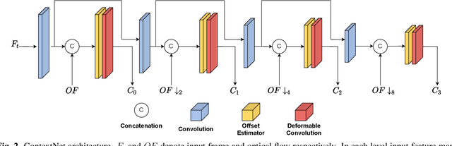
HSTR-Net: Reference Based Video Super-resolution for Aerial Surveillance with Dual Cameras
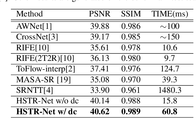
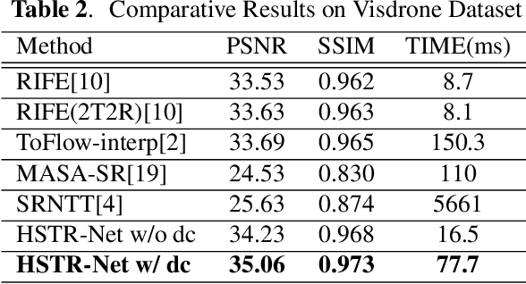
Oct 18, 2023Aerial surveillance requires high spatio-temporal resolution (HSTR) video for more accurate detection and tracking of objects. This is especially true for wide-area surveillance (WAS), where the surveyed region is large and the objects of interest are small. This paper proposes a dual camera system for the generation of HSTR video using reference-based super-resolution (RefSR). One camera captures high spatial resolution low frame rate (HSLF) video while the other captures low spatial resolution high frame rate (LSHF) video simultaneously for the same scene. A novel deep learning architecture is proposed to fuse HSLF and LSHF video feeds and synthesize HSTR video frames at the output. The proposed model combines optical flow estimation and (channel-wise and spatial) attention mechanisms to capture the fine motion and intricate dependencies between frames of the two video feeds. Simulations show that the proposed model provides significant improvement over existing reference-based SR techniques in terms of PSNR and SSIM metrics. The method also exhibits sufficient frames per second (FPS) for WAS when deployed on a power-constrained drone equipped with dual cameras.
HSTR-Net: High Spatio-Temporal Resolution Video Generation For Wide Area Surveillance
Apr 09, 2022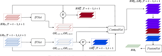
Wide area surveillance has many applications and tracking of objects under observation is an important task, which often needs high spatio-temporal resolution (HSTR) video for better precision. This paper presents the usage of multiple video feeds for the generation of HSTR video as an extension of reference based super resolution (RefSR). One feed captures video at high spatial resolution with low frame rate (HSLF) while the other captures low spatial resolution and high frame rate (LSHF) video simultaneously for the same scene. The main purpose is to create an HSTR video from the fusion of HSLF and LSHF videos. In this paper we propose an end-to-end trainable deep network that performs optical flow estimation and frame reconstruction by combining inputs from both video feeds. The proposed architecture provides significant improvement over existing video frame interpolation and RefSR techniques in terms of objective PSNR and SSIM metrics.
Altitude Optimization of UAV Base Stations from Satellite Images Using Deep Neural Network
Dec 29, 2021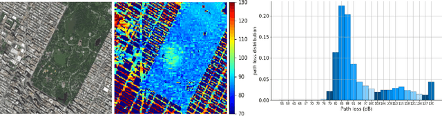
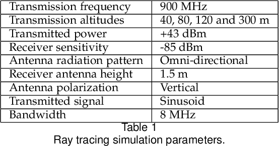
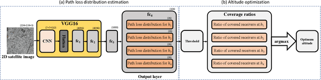
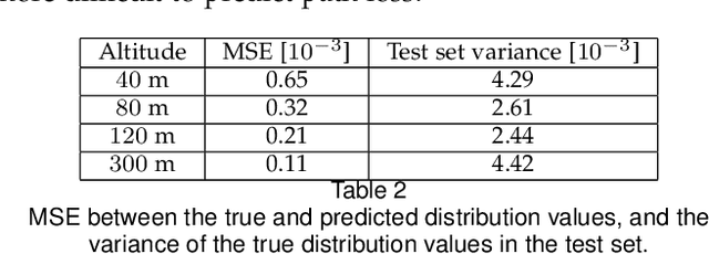
It is expected that unmanned aerial vehicles (UAVs) will play a vital role in future communication systems. Optimum positioning of UAVs, serving as base stations, can be done through extensive field measurements or ray tracing simulations when the 3D model of the region of interest is available. In this paper, we present an alternative approach to optimize UAV base station altitude for a region. The approach is based on deep learning; specifically, a 2D satellite image of the target region is input to a deep neural network to predict path loss distributions for different UAV altitudes. The predicted path distributions are used to calculate the coverage in the region; and the optimum altitude, maximizing the coverage, is determined. The neural network is designed and trained to produce multiple path loss distributions in a single inference; thus, it is not necessary to train a separate network for each altitude.