 Add to Chrome
 Add to Firefox
 Add to Edge
The Potential of Copernicus Satellites for Disaster Response: Retrieving Building Damage from Sentinel-1 and Sentinel-2
Nov 07, 2025


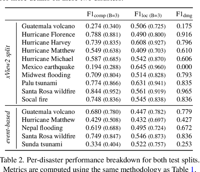
Natural disasters demand rapid damage assessment to guide humanitarian response. Here, we investigate whether medium-resolution Earth observation images from the Copernicus program can support building damage assessment, complementing very-high resolution imagery with often limited availability. We introduce xBD-S12, a dataset of 10,315 pre- and post-disaster image pairs from both Sentinel-1 and Sentinel-2, spatially and temporally aligned with the established xBD benchmark. In a series of experiments, we demonstrate that building damage can be detected and mapped rather well in many disaster scenarios, despite the moderate 10$\,$m ground sampling distance. We also find that, for damage mapping at that resolution, architectural sophistication does not seem to bring much advantage: more complex model architectures tend to struggle with generalization to unseen disasters, and geospatial foundation models bring little practical benefit. Our results suggest that Copernicus images are a viable data source for rapid, wide-area damage assessment and could play an important role alongside VHR imagery. We release the xBD-S12 dataset, code, and trained models to support further research.
SSL4Eco: A Global Seasonal Dataset for Geospatial Foundation Models in Ecology
Apr 25, 2025With the exacerbation of the biodiversity and climate crises, macroecological pursuits such as global biodiversity mapping become more urgent. Remote sensing offers a wealth of Earth observation data for ecological studies, but the scarcity of labeled datasets remains a major challenge. Recently, self-supervised learning has enabled learning representations from unlabeled data, triggering the development of pretrained geospatial models with generalizable features. However, these models are often trained on datasets biased toward areas of high human activity, leaving entire ecological regions underrepresented. Additionally, while some datasets attempt to address seasonality through multi-date imagery, they typically follow calendar seasons rather than local phenological cycles. To better capture vegetation seasonality at a global scale, we propose a simple phenology-informed sampling strategy and introduce corresponding SSL4Eco, a multi-date Sentinel-2 dataset, on which we train an existing model with a season-contrastive objective. We compare representations learned from SSL4Eco against other datasets on diverse ecological downstream tasks and demonstrate that our straightforward sampling method consistently improves representation quality, highlighting the importance of dataset construction. The model pretrained on SSL4Eco reaches state of the art performance on 7 out of 8 downstream tasks spanning (multi-label) classification and regression. We release our code, data, and model weights to support macroecological and computer vision research at https://github.com/PlekhanovaElena/ssl4eco.