 Add to Chrome
 Add to Firefox
 Add to Edge
Enhancing Image Resolution: A Simulation Study and Sensitivity Analysis of System Parameters for Resourcesat-3S/3SA
Oct 30, 2024


Resourcesat-3S/3SA, an upcoming Indian satellite, is designed with Aft and Fore payloads capturing stereo images at look angles of -5deg and 26deg, respectively. Operating at 632.6 km altitude, it features a panchromatic (PAN) band offering a Ground Sampling Distance (GSD) of 1.25 meters and a 60 km swath. To balance swath width and resolution, an Instantaneous Geometric Field of View (IGFOV) of 2.5 meters is maintained while ensuring a 1.25-meter GSD both along and across track. Along-track sampling is achieved through precise timing, while across-track accuracy is ensured by using two staggered pixel arrays. Signal-to-Noise Ratio (SNR) is enhanced through Time Delay and Integration (TDI), employing two five-stage subarrays spaced 80 {\mu}m apart along the track, with a 4 {\mu}m (0.5 pixel) stagger in the across-track direction to achieve 1.25-meter resolution. To further boost resolution, the satellite employs super-resolution (SR), combining multiple low-resolution captures using sub-pixel shifts to produce high-resolution images. This technique, effective when images contain aliased high-frequency details, reconstructs full-resolution imagery using phase information from multiple observations, and has been successfully applied in remote sensing missions like SPOT-5, SkySat, and DubaiSat-1. A Monte Carlo simulation explores the factors influencing the resolution in Resourcesat-3S/3SA, with sensitivity analysis highlighting key impacts. The simulation methodology is broadly applicable to other remote sensing missions, optimizing SR for enhanced image clarity and resolution in future satellite systems.
Geometric Correction and Mosaic Generation of Geo High Resolution Camera Images
Oct 25, 2024


The Geo High Resolution Camera (GHRC) aboard ISRO GSAT-29 satellite is a state-of-the-art 6-band Visible and Near Infrared (VNIR) imager in geostationary orbit at 55degE longitude. It provides a ground sampling distance of 55 meters at nadir, covering 110x110 km at a time, and can image the entire Earth disk using a scan mirror mechanism. To cover India, GHRC uses a two-dimensional raster scanning technique, resulting in over 1,000 scenes that must be stitched into a seamless mosaic. This paper presents the geolocation model and examines potential sources of targeting error, with an assessment of location accuracy. Challenges in inter-band registration and inter-frame mosaicing are addressed through algorithms for geometric correction, band-to-band registration, and seamless mosaic generation. In-flight geometric calibration, including adjustments to the instrument interior alignment angles using ground reference images, has improved pointing and location accuracy. A backtracking algorithm has been developed to correct frame-to-frame mosaicing errors for large-scale mosaics, leveraging geometric models, image processing, and space resection techniques. These advancements now enable the operational generation of full India mosaics with 100-meter resolution and high geometric fidelity, enhancing the GHRC capabilities for Earth observation and monitoring applications.
Advancements in Image Resolution: Super-Resolution Algorithm for Enhanced EOS-06 OCM-3 Data
Oct 24, 2024The Ocean Color Monitor-3 (OCM-3) sensor is instrumental in Earth observation, achieving a critical balance between high-resolution imaging and broad coverage. This paper explores innovative imaging methods employed in OCM-3 and the transformative potential of super-resolution techniques to enhance image quality. The super-resolution model for OCM-3 (SOCM-3) addresses the challenges of contemporary satellite imaging by effectively navigating the trade-off between image clarity and swath width. With resolutions below 240 meters in Local Area Coverage (LAC) mode and below 750 meters in Global Area Coverage (GAC) mode, coupled with a wide 1550-kilometer swath and a 2-day revisit time, SOCM-3 emerges as a leading asset in remote sensing. The paper details the intricate interplay of atmospheric, motion, optical, and detector effects that impact image quality, emphasizing the necessity for advanced computational techniques and sophisticated algorithms for effective image reconstruction. Evaluation methods are thoroughly discussed, incorporating visual assessments using the Blind/Referenceless Image Spatial Quality Evaluator (BRISQUE) metric and computational metrics such as Line Spread Function (LSF), Full Width at Half Maximum (FWHM), and Super-Resolution (SR) ratio. Additionally, statistical analyses, including power spectrum evaluations and target-wise spectral signatures, are employed to gauge the efficacy of super-resolution techniques. By enhancing both spatial resolution and revisit frequency, this study highlights significant advancements in remote sensing capabilities, providing valuable insights for applications across cryospheric, vegetation, oceanic, coastal, and domains. Ultimately, the findings underscore the potential of SOCM-3 to contribute meaningfully to our understanding of finescale oceanic phenomena and environmental monitoring.
Hyperspectral Spatial Super-Resolution using Keystone Error
Oct 24, 2024


Hyperspectral images enable precise identification of ground objects by capturing their spectral signatures with fine spectral resolution.While high spatial resolution further enhances this capability, increasing spatial resolution through hardware like larger telescopes is costly and inefficient. A more optimal solution is using ground processing techniques, such as hypersharpening, to merge high spectral and spatial resolution data. However, this method works best when datasets are captured under similar conditions, which is difficult when using data from different times. In this work, we propose a superresolution approach to enhance hyperspectral data's spatial resolution without auxiliary input. Our method estimates the high-resolution point spread function (PSF) using blind deconvolution and corrects for sampling-related blur using a model-based superresolution framework. This differs from previous approaches by not assuming a known highresolution blur. We also introduce an adaptive prior that improves performance compared to existing methods. Applied to the visible and near-infrared (VNIR) spectrometer of HySIS, ISRO hyperspectral sensor, our algorithm removes aliasing and boosts resolution by approximately 1.3 times. It is versatile and can be applied to similar systems.
Data Processing Chain and Products of EOS-06 OCM-3 Payload From Signal Processing to Geometric Precision
Oct 22, 2024The Ocean Color Monitor-3, launched aboard Oceansat-3, represents a significant advancement in ocean observation technology, building upon the capabilities of its predecessors. With thirteen spectral bands, OCM-3 enhances feature identification and atmospheric correction, enabling precise data collection from a sun-synchronous orbit. With thirteen spectral bands, OCM-3 enhances feature identification and atmospheric correction, enabling precise data collection from a sunsynchronous orbit. Operating at an altitude of 732.5 km, the satellite achieves high signal-to-noise ratios (SNR) through sophisticated onboard and ground processing techniques, including advanced geometric modeling for pixel registration.The OCM-3 processing pipeline, consisting of multiple levels, ensures rigorous calibration and correction of radiometric and geometric data. This paper presents key methodologies such as dark data modeling, photo response non-uniformity correction, and smear correction, are employed to enhance data quality. The effective implementation of ground time delay integration (TDI) allows for the refinement of SNR, with evaluations demonstrating that performance specifications were exceeded. Geometric calibration procedures, including band-to-band registration and geolocation accuracy assessments, which further optimize data reliability are presented in the paper. Advanced image registration techniques leveraging Ground Control Points (GCPs) and residual error analysis significantly reduce geolocation errors, achieving precision within specified thresholds. Overall, OCM-3 comprehensive calibration and processing strategies ensure high-quality, reliable data crucial for ocean monitoring and change detection applications, facilitating improved understanding of ocean dynamics and environmental changes.
CVPR MultiEarth 2023 Deforestation Estimation Challenge:SpaceVision4Amazon
Jul 10, 2023In this paper, we present a deforestation estimation method based on attention guided UNet architecture using Electro-Optical (EO) and Synthetic Aperture Radar (SAR) satellite imagery. For optical images, Landsat-8 and for SAR imagery, Sentinel-1 data have been used to train and validate the proposed model. Due to the unavailability of temporally and spatially collocated data, individual model has been trained for each sensor. During training time Landsat-8 model achieved training and validation pixel accuracy of 93.45% and Sentinel-2 model achieved 83.87% pixel accuracy. During the test set evaluation, the model achieved pixel accuracy of 84.70% with F1-Score of 0.79 and IoU of 0.69.
Monte-Carlo Siamese Policy on Actor for Satellite Image Super Resolution
Apr 08, 2020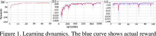
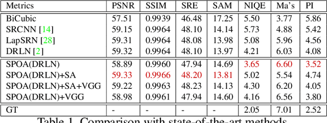
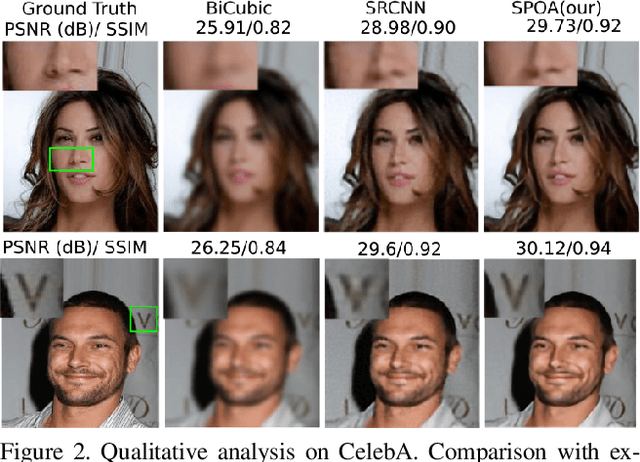
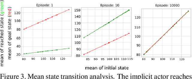
In the past few years supervised and adversarial learning have been widely adopted in various complex computer vision tasks. It seems natural to wonder whether another branch of artificial intelligence, commonly known as Reinforcement Learning (RL) can benefit such complex vision tasks. In this study, we explore the plausible usage of RL in super resolution of remote sensing imagery. Guided by recent advances in super resolution, we propose a theoretical framework that leverages the benefits of supervised and reinforcement learning. We argue that a straightforward implementation of RL is not adequate to address ill-posed super resolution as the action variables are not fully known. To tackle this issue, we propose to parameterize action variables by matrices, and train our policy network using Monte-Carlo sampling. We study the implications of parametric action space in a model-free environment from theoretical and empirical perspective. Furthermore, we analyze the quantitative and qualitative results on both remote sensing and non-remote sensing datasets. Based on our experiments, we report considerable improvement over state-of-the-art methods by encapsulating supervised models in a reinforcement learning framework.
S2A: Wasserstein GAN with Spatio-Spectral Laplacian Attention for Multi-Spectral Band Synthesis
Apr 08, 2020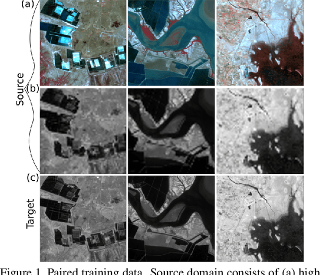
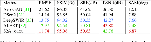
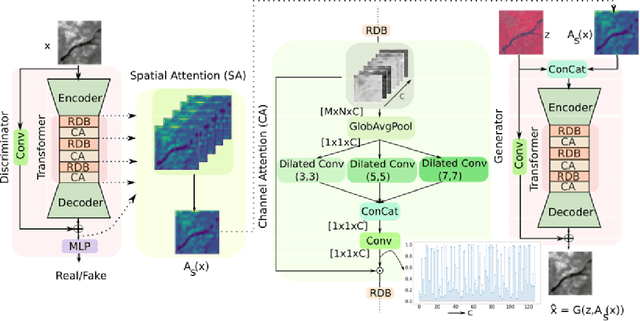
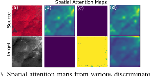
Intersection of adversarial learning and satellite image processing is an emerging field in remote sensing. In this study, we intend to address synthesis of high resolution multi-spectral satellite imagery using adversarial learning. Guided by the discovery of attention mechanism, we regulate the process of band synthesis through spatio-spectral Laplacian attention. Further, we use Wasserstein GAN with gradient penalty norm to improve training and stability of adversarial learning. In this regard, we introduce a new cost function for the discriminator based on spatial attention and domain adaptation loss. We critically analyze the qualitative and quantitative results compared with state-of-the-art methods using widely adopted evaluation metrics. Our experiments on datasets of three different sensors, namely LISS-3, LISS-4, and WorldView-2 show that attention learning performs favorably against state-of-the-art methods. Using the proposed method we provide an additional data product in consistent with existing high resolution bands. Furthermore, we synthesize over 4000 high resolution scenes covering various terrains to analyze scientific fidelity. At the end, we demonstrate plausible large scale real world applications of the synthesized band.