 Add to Chrome
 Add to Firefox
 Add to Edge
SamudrACE: Fast and Accurate Coupled Climate Modeling with 3D Ocean and Atmosphere Emulators
Sep 15, 2025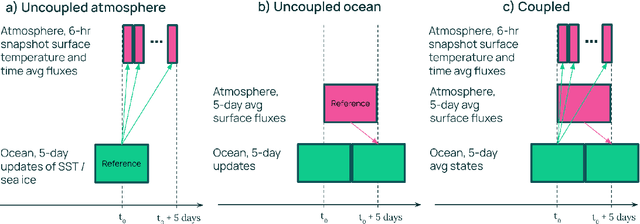
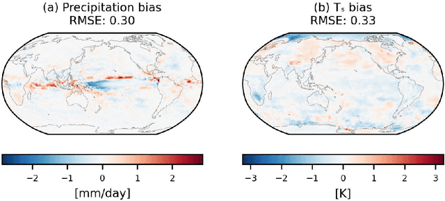
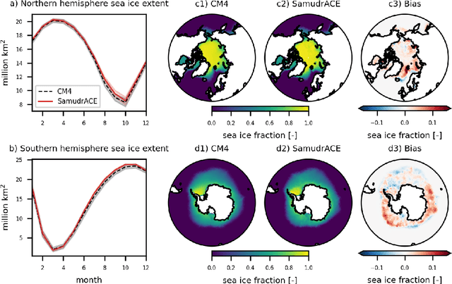
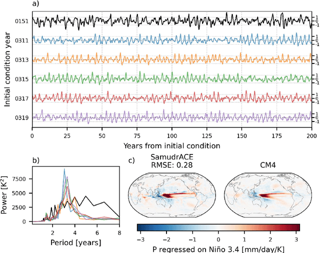
Traditional numerical global climate models simulate the full Earth system by exchanging boundary conditions between separate simulators of the atmosphere, ocean, sea ice, land surface, and other geophysical processes. This paradigm allows for distributed development of individual components within a common framework, unified by a coupler that handles translation between realms via spatial or temporal alignment and flux exchange. Following a similar approach adapted for machine learning-based emulators, we present SamudrACE: a coupled global climate model emulator which produces centuries-long simulations at 1-degree horizontal, 6-hourly atmospheric, and 5-daily oceanic resolution, with 145 2D fields spanning 8 atmospheric and 19 oceanic vertical levels, plus sea ice, surface, and top-of-atmosphere variables. SamudrACE is highly stable and has low climate biases comparable to those of its components with prescribed boundary forcing, with realistic variability in coupled climate phenomena such as ENSO that is not possible to simulate in uncoupled mode.
Probabilistic Precipitation Downscaling with Optical Flow-Guided Diffusion
Dec 11, 2023In climate science and meteorology, local precipitation predictions are limited by the immense computational costs induced by the high spatial resolution that simulation methods require. A common workaround is statistical downscaling (aka superresolution), where a low-resolution prediction is super-resolved using statistical approaches. While traditional computer vision tasks mainly focus on human perception or mean squared error, applications in weather and climate require capturing the conditional distribution of high-resolution patterns given low-resolution patterns so that reliable ensemble averages can be taken. Our approach relies on extending recent video diffusion models to precipitation superresolution: an optical flow on the high-resolution output induces temporally coherent predictions, whereas a temporally-conditioned diffusion model generates residuals that capture the correct noise characteristics and high-frequency patterns. We test our approach on X-SHiELD, an established large-scale climate simulation dataset, and compare against two state-of-the-art baselines, focusing on CRPS, MSE, precipitation distributions, as well as an illustrative case -- the complex terrain of California. Our approach sets a new standard for data-driven precipitation downscaling.