 Add to Chrome
 Add to Firefox
 Add to Edge
DeepSat V2: Feature Augmented Convolutional Neural Nets for Satellite Image Classification
Paper and Code
Nov 15, 2019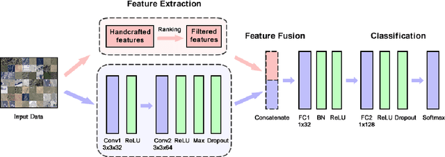
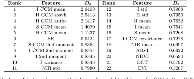
Satellite image classification is a challenging problem that lies at the crossroads of remote sensing, computer vision, and machine learning. Due to the high variability inherent in satellite data, most of the current object classification approaches are not suitable for handling satellite datasets. The progress of satellite image analytics has also been inhibited by the lack of a single labeled high-resolution dataset with multiple class labels. In a preliminary version of this work, we introduced two new high resolution satellite imagery datasets (SAT-4 and SAT-6) and proposed DeepSat framework for classification based on "handcrafted" features and a deep belief network (DBN). The present paper is an extended version, we present an end-to-end framework leveraging an improved architecture that augments a convolutional neural network (CNN) with handcrafted features (instead of using DBN-based architecture) for classification. Our framework, having access to fused spatial information obtained from handcrafted features as well as CNN feature maps, have achieved accuracies of 99.90% and 99.84% respectively, on SAT-4 and SAT-6, surpassing all the other state-of-the-art results. A statistical analysis based on Distribution Separability Criterion substantiates the robustness of our approach in learning better representations for satellite imagery.