 Add to Chrome
 Add to Firefox
 Add to Edge
A lightweight deep learning based cloud detection method for Sentinel-2A imagery fusing multi-scale spectral and spatial features
Apr 29, 2021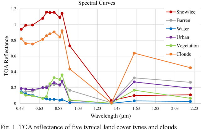
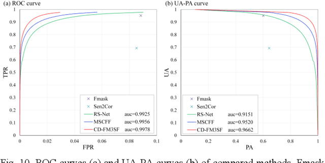
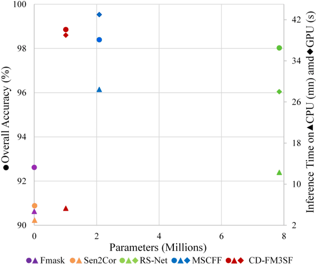
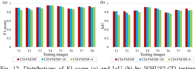
Clouds are a very important factor in the availability of optical remote sensing images. Recently, deep learning-based cloud detection methods have surpassed classical methods based on rules and physical models of clouds. However, most of these deep models are very large which limits their applicability and explainability, while other models do not make use of the full spectral information in multi-spectral images such as Sentinel-2. In this paper, we propose a lightweight network for cloud detection, fusing multi-scale spectral and spatial features (CDFM3SF) and tailored for processing all spectral bands in Sentinel- 2A images. The proposed method consists of an encoder and a decoder. In the encoder, three input branches are designed to handle spectral bands at their native resolution and extract multiscale spectral features. Three novel components are designed: a mixed depth-wise separable convolution (MDSC) and a shared and dilated residual block (SDRB) to extract multi-scale spatial features, and a concatenation and sum (CS) operation to fuse multi-scale spectral and spatial features with little calculation and no additional parameters. The decoder of CD-FM3SF outputs three cloud masks at the same resolution as input bands to enhance the supervision information of small, middle and large clouds. To validate the performance of the proposed method, we manually labeled 36 Sentinel-2A scenes evenly distributed over mainland China. The experiment results demonstrate that CD-FM3SF outperforms traditional cloud detection methods and state-of-theart deep learning-based methods in both accuracy and speed.
Weakly-supervised land classification for coastal zone based on deep convolutional neural networks by incorporating dual-polarimetric characteristics into training dataset
Mar 30, 2020
In this work we explore the performance of DCNNs on semantic segmentation using spaceborne polarimetric synthetic aperture radar (PolSAR) datasets. The semantic segmentation task using PolSAR data can be categorized as weakly supervised learning when the characteristics of SAR data and data annotating procedures are factored in. Datasets are initially analyzed for selecting feasible pre-training images. Then the differences between spaceborne and airborne datasets are examined in terms of spatial resolution and viewing geometry. In this study we used two dual-polarimetric images acquired by TerraSAR-X DLR. A novel method to produce training dataset with more supervised information is developed. Specifically, a series of typical classified images as well as intensity images serve as training datasets. A field survey is conducted for an area of about 20 square kilometers to obtain a ground truth dataset used for accuracy evaluation. Several transfer learning strategies are made for aforementioned training datasets which will be combined in a practicable order. Three DCNN models, including SegNet, U-Net, and LinkNet, are implemented next.