 Add to Chrome
 Add to Firefox
 Add to Edge
Polarimetric SAR Model Fitting for Soil Moisture Retrieval: Study of PALSAR-2 data over a Heterogeneous Mine Environment in Finland
Jul 01, 2026
This paper examines several model based approaches for retrieving surface soil moisture from ALOS-2 PALSAR-2 quad-pol imagery, over a lime stone quarry in southeastern Finland. The study primarily targets physically interpretable semi-empirical modeling approaches, with generic ML modeling used as a benchmark. Along with common polarimetric observables, we propose a generalization of the SAR time series based TU Wien soil moisture index (SMI) retrievals examined across several representational spaces derived from polarimetric coherency matrix $[T3]$. This study was conducted over a closed tailing storage facility and a landfill, with a set of 9 repeat pass PALSAR-2 images. The best semi-empirical configuration combining temporal context SMI and current observation PolSAR parameters achieved $R^2=0.67$ and RMSE $=5.65$ volumetric \% units. The strongest $SMI_{[T3]}$ approach with sediment-specific calibration, achieved $R^2=0.66$ and RMSE $=5.67$ vol. \%, which was considerably better than using $SMI_{HH}$ or $SMI_{VV}$. The proposed approach was sensitive to representations: dB-based projection outperformed linear or trace-normalized $[T3]$ representation. Factoring in sediment information dramatically improved retrieval performance compared to using global model fitting. Machine learning results closely approached but not outperformed semi-empirical model based methodologies. Similarly, they highlighted the need for sediment-specific modeling as well as the importance of including time-series/temporal backscatter dynamics during SSM retrieval. Our study demonstrated the utility of physics based SSM retrieval approaches in the complex multi-sediment mine environment under relatively scarce reference data conditions.

High Resolution Sediment-Specific Surface Soil Moisture Retrieval Using Sentinel-1 Time Series and Auxiliary Data
Jun 23, 2026In this study, we examine the potential of continuous ground moisture monitoring over a mining site using a combination of in-situ soil moisture sensors and multi-sensor SAR images. We focus on assessing and improving methodologies for retrieval of surface soil moisture, i.e. ground moisture, from SAR measurements focusing on detailed in situ reference observations for several key geomaterials, i.e. sediments, typical in the study site. The mining site represents a limestone quarry locate in the southeastern Finland. Our hypothesis is that sediment-specific well-calibrated models can be instrumental in improving soil moisture retrieval under different weather conditions to produce spatially explicit soil moisture estimates at high resolution compared to baseline approaches. Studied SAR data are represented by Copernicus Sentinel-1 C-band images, while auxiliary datasets include optical Sentinel-2 data. Reference data were collected using IoT enabled capacitance sensors. The examined machine learning methods include Xgboost, LightGBM, RFs, linear regression and k-nearest neighbors regression. The best performance was achieved with the most comprehensive feature set which combines Sentinel-1 backscatter, time-series based soil moisture indices, Sentinel-2 optical, topographic, and temperature predictors. In the best sediment-area-level configurations, RMSE decreased to 0.037-0.050 m^3 m^(-3) (3.7-5.0 volumetric % points), with R^2 values reaching 0.90. Tree-based ensemble methods, especially LightGBM, RF, and XGBoost, provided the most accurate and stable predictions. Accuracy varied by sediment texture, with the lowest errors for clay and organic soil and higher errors for flotation sand and gravel. Adding sediment information improved Sentinel-1-only retrievals by more than 2 vol-%, but provided little additional benefit when richer multi-source feature sets were used.
A lightweight deep learning based cloud detection method for Sentinel-2A imagery fusing multi-scale spectral and spatial features
Apr 29, 2021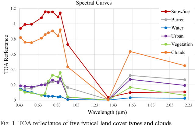
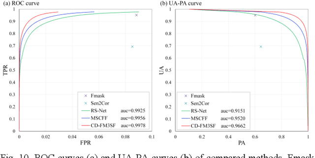
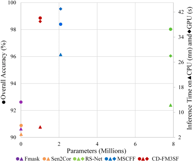
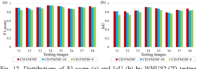
Clouds are a very important factor in the availability of optical remote sensing images. Recently, deep learning-based cloud detection methods have surpassed classical methods based on rules and physical models of clouds. However, most of these deep models are very large which limits their applicability and explainability, while other models do not make use of the full spectral information in multi-spectral images such as Sentinel-2. In this paper, we propose a lightweight network for cloud detection, fusing multi-scale spectral and spatial features (CDFM3SF) and tailored for processing all spectral bands in Sentinel- 2A images. The proposed method consists of an encoder and a decoder. In the encoder, three input branches are designed to handle spectral bands at their native resolution and extract multiscale spectral features. Three novel components are designed: a mixed depth-wise separable convolution (MDSC) and a shared and dilated residual block (SDRB) to extract multi-scale spatial features, and a concatenation and sum (CS) operation to fuse multi-scale spectral and spatial features with little calculation and no additional parameters. The decoder of CD-FM3SF outputs three cloud masks at the same resolution as input bands to enhance the supervision information of small, middle and large clouds. To validate the performance of the proposed method, we manually labeled 36 Sentinel-2A scenes evenly distributed over mainland China. The experiment results demonstrate that CD-FM3SF outperforms traditional cloud detection methods and state-of-theart deep learning-based methods in both accuracy and speed.
Binary Patterns Encoded Convolutional Neural Networks for Texture Recognition and Remote Sensing Scene Classification
Mar 26, 2018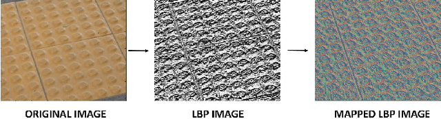
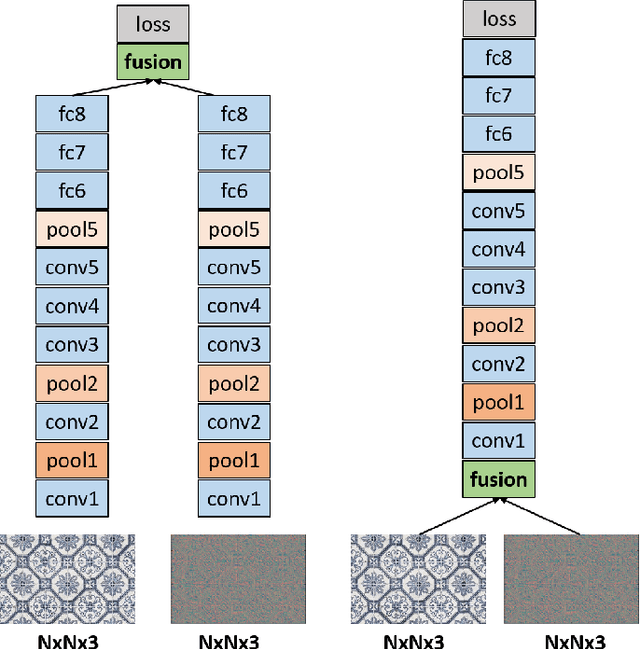

Designing discriminative powerful texture features robust to realistic imaging conditions is a challenging computer vision problem with many applications, including material recognition and analysis of satellite or aerial imagery. In the past, most texture description approaches were based on dense orderless statistical distribution of local features. However, most recent approaches to texture recognition and remote sensing scene classification are based on Convolutional Neural Networks (CNNs). The d facto practice when learning these CNN models is to use RGB patches as input with training performed on large amounts of labeled data (ImageNet). In this paper, we show that Binary Patterns encoded CNN models, codenamed TEX-Nets, trained using mapped coded images with explicit texture information provide complementary information to the standard RGB deep models. Additionally, two deep architectures, namely early and late fusion, are investigated to combine the texture and color information. To the best of our knowledge, we are the first to investigate Binary Patterns encoded CNNs and different deep network fusion architectures for texture recognition and remote sensing scene classification. We perform comprehensive experiments on four texture recognition datasets and four remote sensing scene classification benchmarks: UC-Merced with 21 scene categories, WHU-RS19 with 19 scene classes, RSSCN7 with 7 categories and the recently introduced large scale aerial image dataset (AID) with 30 aerial scene types. We demonstrate that TEX-Nets provide complementary information to standard RGB deep model of the same network architecture. Our late fusion TEX-Net architecture always improves the overall performance compared to the standard RGB network on both recognition problems. Our final combination outperforms the state-of-the-art without employing fine-tuning or ensemble of RGB network architectures.