 Add to Chrome
 Add to Firefox
 Add to Edge
SIO-Mapper: A Framework for Lane-Level HD Map Construction Using Satellite Images and OpenStreetMap with No On-Site Visits
Apr 14, 2025High-definition (HD) maps, particularly those containing lane-level information regarded as ground truth, are crucial for vehicle localization research. Traditionally, constructing HD maps requires highly accurate sensor measurements collection from the target area, followed by manual annotation to assign semantic information. Consequently, HD maps are limited in terms of geographic coverage. To tackle this problem, in this paper, we propose SIO-Mapper, a novel lane-level HD map construction framework that constructs city-scale maps without physical site visits by utilizing satellite images and OpenStreetmap data. One of the key contributions of SIO-Mapper is its ability to extract lane information more accurately by introducing SIO-Net, a novel deep learning network that integrates features from satellite image and OpenStreetmap using both Transformer-based and convolution-based encoders. Furthermore, to overcome challenges in merging lanes over large areas, we introduce a novel lane integration methodology that combines cluster-based and graph-based approaches. This algorithm ensures the seamless aggregation of lane segments with high accuracy and coverage, even in complex road environments. We validated SIO-Mapper on the Naver Labs Open Dataset and NuScenes dataset, demonstrating better performance in various environments including Korea, the United States, and Singapore compared to the state-of-the-art lane-level HD mapconstruction methods.
OpenStreetMap-based LiDAR Global Localization in Urban Environment without a Prior LiDAR Map
Feb 15, 2022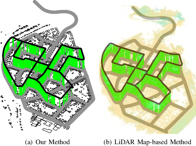
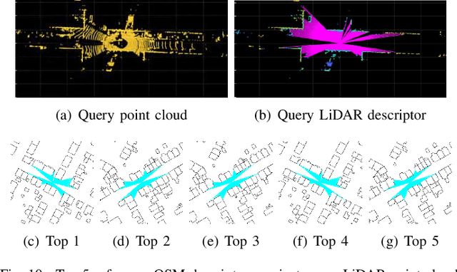
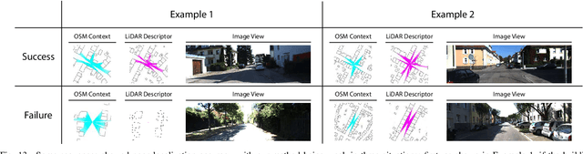
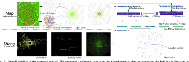
Using publicly accessible maps, we propose a novel vehicle localization method that can be applied without using prior light detection and ranging (LiDAR) maps. Our method generates OSM descriptors by calculating the distances to buildings from a location in OpenStreetMap at a regular angle, and LiDAR descriptors by calculating the shortest distances to building points from the current location at a regular angle. Comparing the OSM descriptors and LiDAR descriptors yields a highly accurate vehicle localization result. Compared to methods that use prior LiDAR maps, our method presents two main advantages: (1) vehicle localization is not limited to only places with previously acquired LiDAR maps, and (2) our method is comparable to LiDAR map-based methods, and especially outperforms the other methods with respect to the top one candidate at KITTI dataset sequence 00.