Usman Nazir
Data-Driven Approach to assess and identify gaps in healthcare set up in South Asia
Sep 21, 2024


Abstract:Primary healthcare is a crucial strategy for achieving universal health coverage. South Asian countries are working to improve their primary healthcare system through their country specific policies designed in line with WHO health system framework using the six thematic pillars: Health Financing, Health Service delivery, Human Resource for Health, Health Information Systems, Governance, Essential Medicines and Technology, and an addition area of Cross-Sectoral Linkages. Measuring the current accessibility of healthcare facilities and workforce availability is essential for improving healthcare standards and achieving universal health coverage in developing countries. Data-driven surveillance approaches are required that can provide rapid, reliable, and geographically scalable solutions to understand a) which communities and areas are most at risk of inequitable access and when, b) what barriers to health access exist, and c) how they can be overcome in ways tailored to the specific challenges faced by individual communities. We propose to harness current breakthroughs in Earth-observation (EO) technology, which provide the ability to generate accurate, up-to-date, publicly accessible, and reliable data, which is necessary for equitable access planning and resource allocation to ensure that vaccines, and other interventions reach everyone, particularly those in greatest need, during normal and crisis times. This requires collaboration among countries to identify evidence based solutions to shape health policy and interventions, and drive innovations and research in the region.
Learning adjacency matrix for dynamic graph neural network
Oct 04, 2023


Abstract:In recent work, [1] introduced the concept of using a Block Adjacency Matrix (BA) for the representation of spatio-temporal data. While their method successfully concatenated adjacency matrices to encapsulate spatio-temporal relationships in a single graph, it formed a disconnected graph. This limitation hampered the ability of Graph Convolutional Networks (GCNs) to perform message passing across nodes belonging to different time steps, as no temporal links were present. To overcome this challenge, we introduce an encoder block specifically designed to learn these missing temporal links. The encoder block processes the BA and predicts connections between previously unconnected subgraphs, resulting in a Spatio-Temporal Block Adjacency Matrix (STBAM). This enriched matrix is then fed into a Graph Neural Network (GNN) to capture the complex spatio-temporal topology of the network. Our evaluations on benchmark datasets, surgVisDom and C2D2, demonstrate that our method, with slightly higher complexity, achieves superior results compared to state-of-the-art results. Our approach's computational overhead remains significantly lower than conventional non-graph-based methodologies for spatio-temporal data.
Improved flood mapping for efficient policy design by fusion of Sentinel-1, Sentinel-2, and Landsat-9 imagery to identify population and infrastructure exposed to floods
May 31, 2023Abstract:A reliable yet inexpensive tool for the estimation of flood water spread is conducive for efficient disaster management. The application of optical and SAR imagery in tandem provides a means of extended availability and enhanced reliability of flood mapping. We propose a methodology to merge these two types of imagery into a common data space and demonstrate its use in the identification of affected populations and infrastructure for the 2022 floods in Pakistan. The merging of optical and SAR data provides us with improved observations in cloud-prone regions; that is then used to gain additional insights into flood mapping applications. The use of open source datasets from WorldPop and OSM for population and roads respectively makes the exercise globally replicable. The integration of flood maps with spatial data on population and infrastructure facilitates informed policy design. We have shown that within the top five flood-affected districts in Sindh province, Pakistan, the affected population accounts for 31 %, while the length of affected roads measures 1410.25 km out of a total of 7537.96 km.
Feature Selection on Sentinel-2 Multi-spectral Imagery for Efficient Tree Cover Estimation
May 31, 2023Abstract:This paper proposes a multi-spectral random forest classifier with suitable feature selection and masking for tree cover estimation in urban areas. The key feature of the proposed classifier is filtering out the built-up region using spectral indices followed by random forest classification on the remaining mask with carefully selected features. Using Sentinel-2 satellite imagery, we evaluate the performance of the proposed technique on a specified area (approximately 82 acres) of Lahore University of Management Sciences (LUMS) and demonstrate that our method outperforms a conventional random forest classifier as well as state-of-the-art methods such as European Space Agency (ESA) WorldCover 10m 2020 product as well as a DeepLabv3 deep learning architecture.
Mitigating climate and health impact of small-scale kiln industry using multi-spectral classifier and deep learning
Mar 21, 2023Abstract:Industrial air pollution has a direct health impact and is a major contributor to climate change. Small scale industries particularly bull-trench brick kilns are one of the major causes of air pollution in South Asia often creating hazardous levels of smog that is injurious to human health. To mitigate the climate and health impact of the kiln industry, fine-grained kiln localization at different geographic locations is needed. Kiln localization using multi-spectral remote sensing data such as vegetation index results in a noisy estimates whereas use of high-resolution imagery is infeasible due to cost and compute complexities. This paper proposes a fusion of spatio-temporal multi-spectral data with high-resolution imagery for detection of brick kilns within the "Brick-Kiln-Belt" of South Asia. We first perform classification using low-resolution spatio-temporal multi-spectral data from Sentinel-2 imagery by combining vegetation, burn, build up and moisture indices. Then orientation aware object detector: YOLOv3 (with theta value) is implemented for removal of false detections and fine-grained localization. Our proposed technique, when compared with other benchmarks, results in a 21x improvement in speed with comparable or higher accuracy when tested over multiple countries.
Survey of Image Based Graph Neural Networks
Jun 11, 2021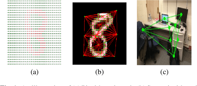

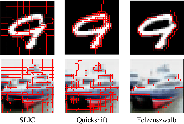
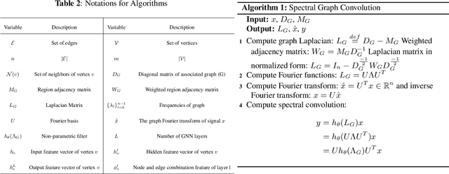
Abstract:In this survey paper, we analyze image based graph neural networks and propose a three-step classification approach. We first convert the image into superpixels using the Quickshift algorithm so as to reduce 30% of the input data. The superpixels are subsequently used to generate a region adjacency graph. Finally, the graph is passed through a state-of-art graph convolutional neural network to get classification scores. We also analyze the spatial and spectral convolution filtering techniques in graph neural networks. Spectral-based models perform better than spatial-based models and classical CNN with lesser compute cost.
Tiny-Inception-ResNet-v2: Using Deep Learning for Eliminating Bonded Labors of Brick Kilns in South Asia
Jul 12, 2019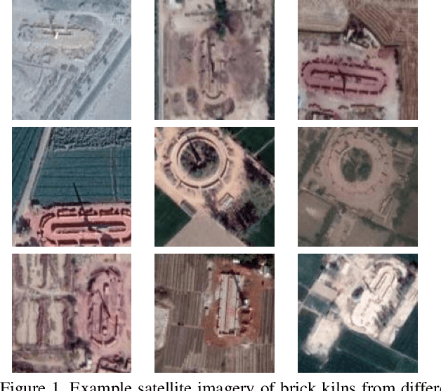
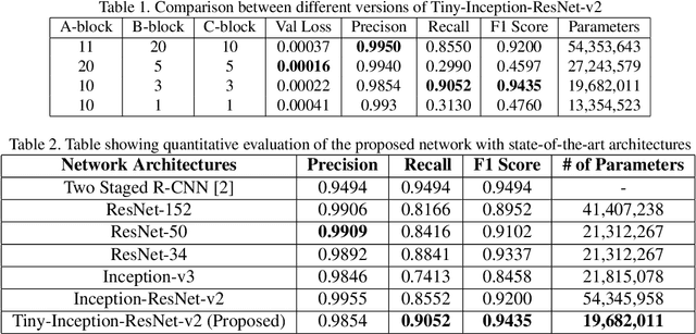
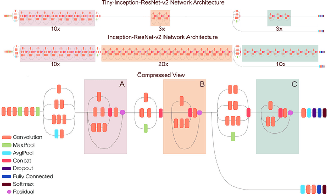
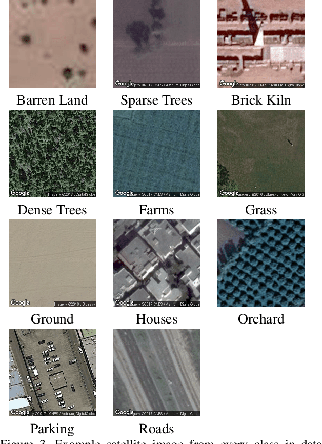
Abstract:This paper proposes to employ a Inception-ResNet inspired deep learning architecture called Tiny-Inception-ResNet-v2 to eliminate bonded labor by identifying brick kilns within "Brick-Kiln-Belt" of South Asia. The framework is developed by training a network on the satellite imagery consisting of 11 different classes of South Asian region. The dataset developed during the process includes the geo-referenced images of brick kilns, houses, roads, tennis courts, farms, sparse trees, dense trees, orchards, parking lots, parks and barren lands. The dataset is made publicly available for further research. Our proposed network architecture with very fewer learning parameters outperforms all state-of-the-art architectures employed for recognition of brick kilns. Our proposed solution would enable regional monitoring and evaluation mechanisms for the Sustainable Development Goals.
Accurate Localization in Wireless Sensor Networks in the Presence of Cross Technology Interference
May 25, 2019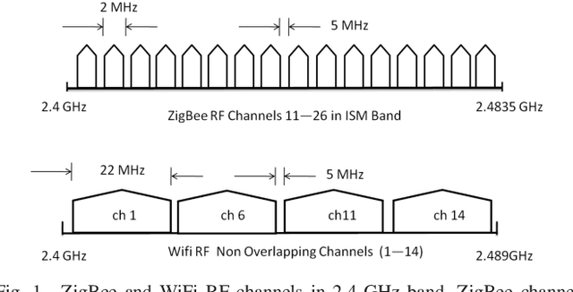
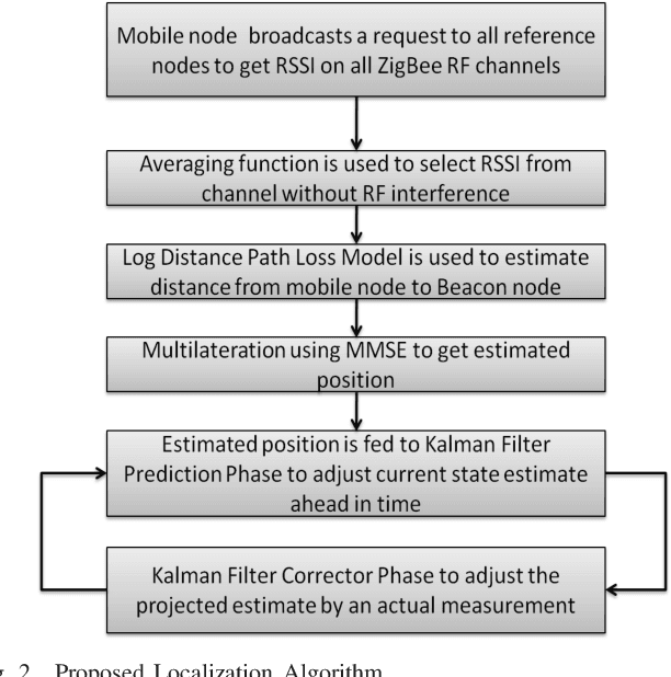
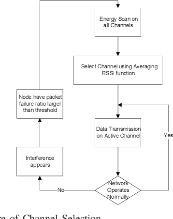
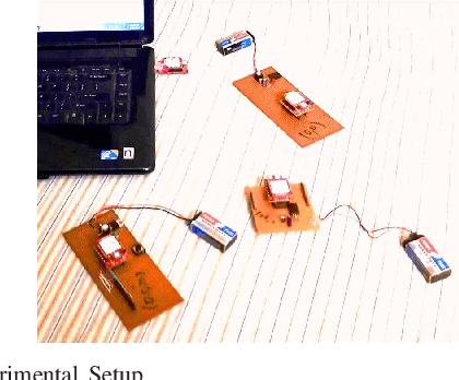
Abstract:Localization of mobile nodes in a wireless sensor networks (WSNs) is an active area of research. In this paper, we present a novel RSSI based localization algorithm for 802.15.4 (ZigBee) based WSNs. We propose and implement a novel range based localization algorithm to minimize cross technology interference operating in the same band. The goal is to minimize the mean square error of the localization algorithm. Hardware implementation of the algorithm is in agreement with ideal (no interference) simulation results where an accuracy of less than 0.5m has been achieved.
 Add to Chrome
 Add to Firefox
 Add to Edge