 Add to Chrome
 Add to Firefox
 Add to Edge
Global Offshore Wind Infrastructure: Deployment and Operational Dynamics from Dense Sentinel-1 Time Series
Apr 22, 2026The offshore wind energy sector is expanding rapidly, increasing the need for independent, high-temporal-resolution monitoring of infrastructure deployment and operation at global scale. While Earth Observation based offshore wind infrastructure mapping has matured for spatial localization, existing open datasets lack temporally dense and semantically fine-grained information on construction and operational dynamics. We introduce a global Sentinel-1 synthetic aperture radar (SAR) time series data corpus that resolves deployment and operational phases of offshore wind infrastructure from 2016Q1 to 2025Q1. Building on an updated object detection workflow, we compile 15,606 time series at detected infrastructure locations, with overall 14,840,637 events as analysis-ready 1D SAR backscatter profiles, one profile per Sentinel-1 acquisition and location. To enable direct use and benchmarking, we release (i) the analysis ready 1D SAR profiles, (ii) event-level baseline semantic labels generated by a rule-based classifier, and (iii) an expert-annotated benchmark dataset of 553 time series with 328,657 event labels. The baseline classifier achieves a macro F1 score of 0.84 in event-wise evaluation and an area under the collapsed edit similarity-quality threshold curve (AUC) of 0.785, indicating temporal coherence. We demonstrate that the resulting corpus supports global-scale analyses of deployment dynamics, the identification of differences in regional deployment patterns, vessel interactions, and operational events, and provides a reference for developing and comparing time series classification methods for offshore wind infrastructure monitoring.
Offshore oil and gas platform dynamics in the North Sea, Gulf of Mexico, and Persian Gulf: Exploiting the Sentinel-1 archive
Mar 20, 2026The increasing use of marine spaces by offshore infrastructure, including oil and gas platforms, underscores the need for consistent, scalable monitoring. Offshore development has economic, environmental, and regulatory implications, yet maritime areas remain difficult to monitor systematically due to their inaccessibility and spatial extent. This study presents an automated approach to the spatiotemporal detection of offshore oil and gas platforms based on freely available Earth observation data. Leveraging Sentinel-1 archive data and deep learning-based object detection, a consistent quarterly time series of platform locations for three major production regions: the North Sea, the Gulf of Mexico, and the Persian Gulf, was created for the period 2017-2025. In addition, platform size, water depth, distance to the coast, national affiliation, and installation and decommissioning dates were derived. 3,728 offshore platforms were identified in 2025, 356 in the North Sea, 1,641 in the Gulf of Mexico, and 1,731 in the Persian Gulf. While expansion was observed in the Persian Gulf until 2024, the Gulf of Mexico and the North Sea saw a decline in platform numbers from 2018-2020. At the same time, a pronounced dynamic was apparent. More than 2,700 platforms were installed or relocated to new sites, while a comparable number were decommissioned or relocated. Furthermore, the increasing number of platforms with short lifespans points to a structural change in the offshore sector associated with the growing importance of mobile offshore units such as jack-ups or drillships. The results highlighted the potential of freely available Earth observation data and deep learning for consistent, long-term monitoring of marine infrastructure. The derived dataset is public and provides a basis for offshore monitoring, maritime planning, and analyses of the transformation of the offshore energy sector.
Deep learning-based object detection of offshore platforms on Sentinel-1 Imagery and the impact of synthetic training data
Nov 06, 2025


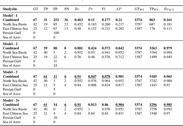
The recent and ongoing expansion of marine infrastructure, including offshore wind farms, oil and gas platforms, artificial islands, and aquaculture facilities, highlights the need for effective monitoring systems. The development of robust models for offshore infrastructure detection relies on comprehensive, balanced datasets, but falls short when samples are scarce, particularly for underrepresented object classes, shapes, and sizes. By training deep learning-based YOLOv10 object detection models with a combination of synthetic and real Sentinel-1 satellite imagery acquired in the fourth quarter of 2023 from four regions (Caspian Sea, South China Sea, Gulf of Guinea, and Coast of Brazil), this study investigates the use of synthetic training data to enhance model performance. We evaluated this approach by applying the model to detect offshore platforms in three unseen regions (Gulf of Mexico, North Sea, Persian Gulf) and thereby assess geographic transferability. This region-holdout evaluation demonstrated that the model generalises beyond the training areas. In total, 3,529 offshore platforms were detected, including 411 in the North Sea, 1,519 in the Gulf of Mexico, and 1,593 in the Persian Gulf. The model achieved an F1 score of 0.85, which improved to 0.90 upon incorporating synthetic data. We analysed how synthetic data enhances the representation of unbalanced classes and overall model performance, taking a first step toward globally transferable detection of offshore infrastructure. This study underscores the importance of balanced datasets and highlights synthetic data generation as an effective strategy to address common challenges in remote sensing, demonstrating the potential of deep learning for scalable, global offshore infrastructure monitoring.
SyntEO: Synthetic Dataset Generation for Earth Observation with Deep Learning -- Demonstrated for Offshore Wind Farm Detection
Dec 06, 2021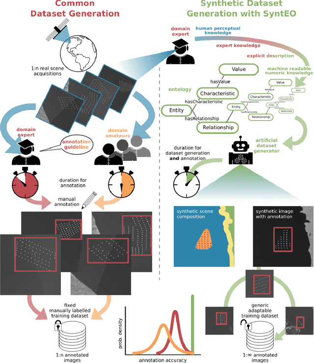
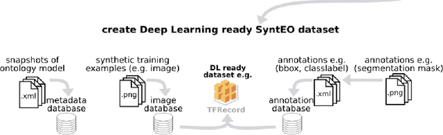
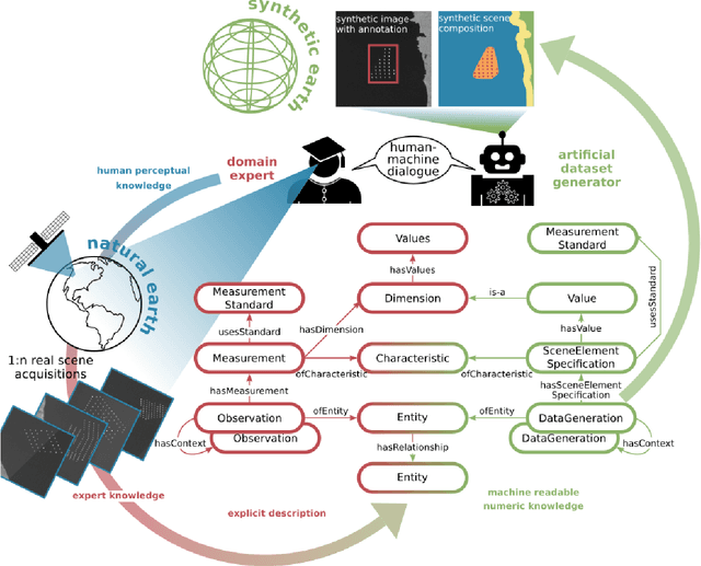
With the emergence of deep learning in the last years, new opportunities arose in Earth observation research. Nevertheless, they also brought with them new challenges. The data-hungry training processes of deep learning models demand large, resource expensive, annotated datasets and partly replaced knowledge-driven approaches, so that model behaviour and the final prediction process became a black box. The proposed SyntEO approach enables Earth observation researchers to automatically generate large deep learning ready datasets and thus free up otherwise occupied resources. SyntEO does this by including expert knowledge in the data generation process in a highly structured manner. In this way, fully controllable experiment environments are set up, which support insights in the model training. Thus, SyntEO makes the learning process approachable and model behaviour interpretable, an important cornerstone for explainable machine learning. We demonstrate the SyntEO approach by predicting offshore wind farms in Sentinel-1 images on two of the worlds largest offshore wind energy production sites. The largest generated dataset has 90,000 training examples. A basic convolutional neural network for object detection, that is only trained on this synthetic data, confidently detects offshore wind farms by minimising false detections in challenging environments. In addition, four sequential datasets are generated, demonstrating how the SyntEO approach can precisely define the dataset structure and influence the training process. SyntEO is thus a hybrid approach that creates an interface between expert knowledge and data-driven image analysis.