 Add to Chrome
 Add to Firefox
 Add to Edge
HighFM: Towards a Foundation Model for Learning Representations from High-Frequency Earth Observation Data
Apr 05, 2026The increasing frequency and severity of climate related disasters have intensified the need for real time monitoring, early warning, and informed decision-making. Earth Observation (EO), powered by satellite data and Machine Learning (ML), offers powerful tools to meet these challenges. Foundation Models (FMs) have revolutionized EO ML by enabling general-purpose pretraining on large scale remote sensing datasets. However most existing models rely on high-resolution satellite imagery with low revisit rates limiting their suitability for fast-evolving phenomena and time critical emergency response. In this work, we present HighFM, a first cut approach towards a FM for high temporal resolution, multispectral EO data. Leveraging over 2 TB of SEVIRI imagery from the Meteosat Second Generation (MSG) platform, we adapt the SatMAE masked autoencoding framework to learn robust spatiotemporal representations. To support real time monitoring, we enhance the original architecture with fine grained temporal encodings to capture short term variability. The pretrained models are then finetuned on cloud masking and active fire detection tasks. We benchmark our SEVIRI pretrained Vision Transformers against traditional baselines and recent geospatial FMs, demonstrating consistent gains across both balanced accuracy and IoU metrics. Our results highlight the potential of temporally dense geostationary data for real-time EO, offering a scalable path toward foundation models for disaster detection and tracking.
Global 3D Reconstruction of Clouds & Tropical Cyclones
Nov 06, 2025Accurate forecasting of tropical cyclones (TCs) remains challenging due to limited satellite observations probing TC structure and difficulties in resolving cloud properties involved in TC intensification. Recent research has demonstrated the capabilities of machine learning methods for 3D cloud reconstruction from satellite observations. However, existing approaches have been restricted to regions where TCs are uncommon, and are poorly validated for intense storms. We introduce a new framework, based on a pre-training--fine-tuning pipeline, that learns from multiple satellites with global coverage to translate 2D satellite imagery into 3D cloud maps of relevant cloud properties. We apply our model to a custom-built TC dataset to evaluate performance in the most challenging and relevant conditions. We show that we can - for the first time - create global instantaneous 3D cloud maps and accurately reconstruct the 3D structure of intense storms. Our model not only extends available satellite observations but also provides estimates when observations are missing entirely. This is crucial for advancing our understanding of TC intensification and improving forecasts.
3D Cloud reconstruction through geospatially-aware Masked Autoencoders
Jan 03, 2025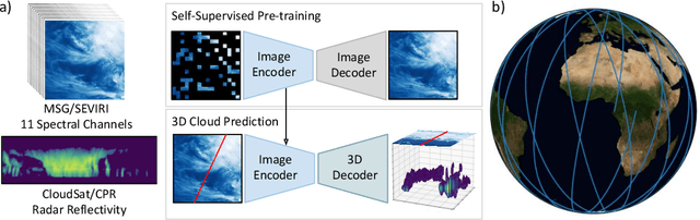
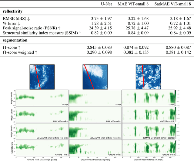
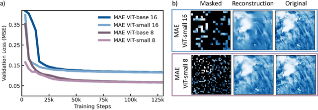
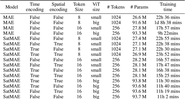
Clouds play a key role in Earth's radiation balance with complex effects that introduce large uncertainties into climate models. Real-time 3D cloud data is essential for improving climate predictions. This study leverages geostationary imagery from MSG/SEVIRI and radar reflectivity measurements of cloud profiles from CloudSat/CPR to reconstruct 3D cloud structures. We first apply self-supervised learning (SSL) methods-Masked Autoencoders (MAE) and geospatially-aware SatMAE on unlabelled MSG images, and then fine-tune our models on matched image-profile pairs. Our approach outperforms state-of-the-art methods like U-Nets, and our geospatial encoding further improves prediction results, demonstrating the potential of SSL for cloud reconstruction.
Next day fire prediction via semantic segmentation
Mar 20, 2024


In this paper we present a deep learning pipeline for next day fire prediction. The next day fire prediction task consists in learning models that receive as input the available information for an area up until a certain day, in order to predict the occurrence of fire for the next day. Starting from our previous problem formulation as a binary classification task on instances (daily snapshots of each area) represented by tabular feature vectors, we reformulate the problem as a semantic segmentation task on images; there, each pixel corresponds to a daily snapshot of an area, while its channels represent the formerly tabular training features. We demonstrate that this problem formulation, built within a thorough pipeline achieves state of the art results.