 Add to Chrome
 Add to Firefox
 Add to Edge
Co-Learning for Missing Arbitrary Modalities in Multi-modal Classification
Jul 27, 2026
Multi-modal classification leverages complementary information across diverse data sources to enhance predictive performance. However, real-world scenarios subject to operational constraints, such as sensor failures or privacy restrictions, lead to inconsistent modality availability between training and inference times. To handle missing modalities, prior studies have mainly covered bimodal data setups and focused on designing robust fusion processes. Instead, we adopt a multi-modal co-learning framework that prioritizes inter-modal collaboration rather than multi-modal fusion. Specifically, we consider that any subset of modalities may be absent, without assuming predefined missing-modality patterns, an inference scenario we refer to as missing arbitrary modalities. To address this challenge, we introduce two alternative approaches that leverage information at both feature- and decision-level. Experiments on two multi-modal classification benchmarks demonstrate significant robustness gains in various missing modality conditions. The first method shows more robust behavior under minimal missing conditions, where a single modality is absent, whereas the second performs better under extreme missing conditions, where all-but-one modalities are missing. Our code is available at https://github.com/fmenat/Co4Miss.

Biomazon: A Multimodal Dataset for 3D Forest Structure and Biomass Modeling in the Amazon Basin
Jun 03, 2026Accurate, spatially explicit characterization of tropical forest structure is essential for carbon accounting and ecosystem monitoring, yet most ML pipelines predict canopy-top height proxies (e.g., RH95/RH98) or AGBD as separate scalar targets, rather than learning the forest vertical structure as an ordered profile. The community lacks a ML-ready multimodal benchmark for predicting the entire GEDI RH profile jointly with AGBD, or for evaluating methods that enforce physically consistent ordering across RH percentiles. We address this with Biomazon, a 20 m multimodal benchmark dataset over the Amazon Basin that pairs GEDI RH and AGBD targets with multi-sensor predictors (Sentinel-1/2, ALOS-2 PALSAR-2, Copernicus DEM, Dynamic World LULC, and AlphaEarth embeddings) under standardized spatial splits and evaluation protocols. Using a shared encoder-decoder with task-specific heads as a baseline framework, we conduct a comprehensive ablation study of (i) backbone/model scale, (ii) modality contributions, and (iii) the use of auxiliary embeddings under standalone and fusion settings, and we report both single-target and joint-target results to quantify tradeoffs under a unified training protocol. Finally, we contextualize baseline performance through regionally aligned comparisons against existing gridded products, including GEDI L4D RH10-RH98 and AGBD, at matching temporal scale. Biomazon, together with the accompanying protocols and baseline results, establishes a reference benchmark for future work on structurally consistent RH-profile prediction and structure-biomass modeling in tropical forests.
HyBiomass: Global Hyperspectral Imagery Benchmark Dataset for Evaluating Geospatial Foundation Models in Forest Aboveground Biomass Estimation
Jun 12, 2025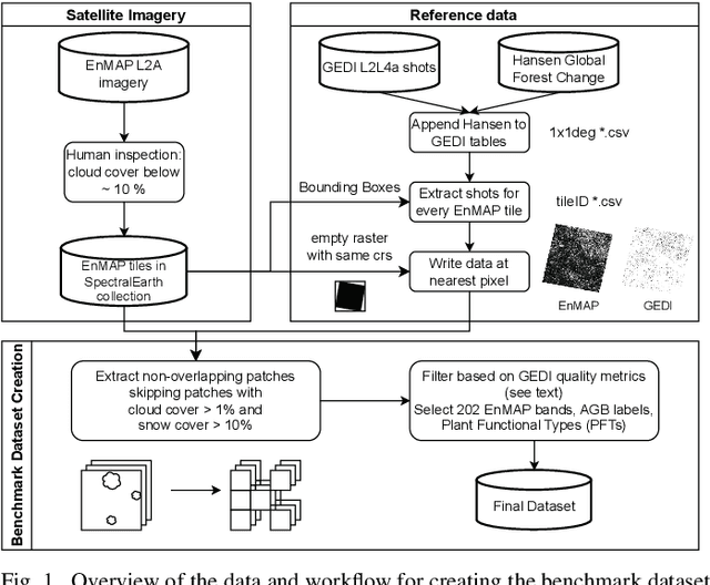
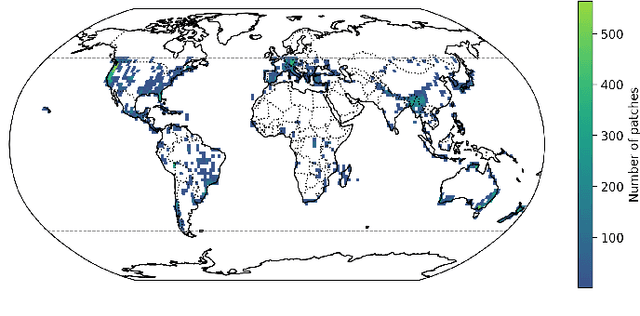
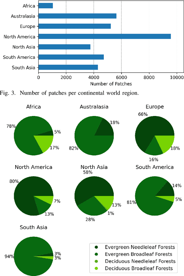
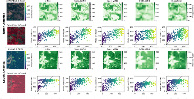
Comprehensive evaluation of geospatial foundation models (Geo-FMs) requires benchmarking across diverse tasks, sensors, and geographic regions. However, most existing benchmark datasets are limited to segmentation or classification tasks, and focus on specific geographic areas. To address this gap, we introduce a globally distributed dataset for forest aboveground biomass (AGB) estimation, a pixel-wise regression task. This benchmark dataset combines co-located hyperspectral imagery (HSI) from the Environmental Mapping and Analysis Program (EnMAP) satellite and predictions of AGB density estimates derived from the Global Ecosystem Dynamics Investigation lidars, covering seven continental regions. Our experimental results on this dataset demonstrate that the evaluated Geo-FMs can match or, in some cases, surpass the performance of a baseline U-Net, especially when fine-tuning the encoder. We also find that the performance difference between the U-Net and Geo-FMs depends on the dataset size for each region and highlight the importance of the token patch size in the Vision Transformer backbone for accurate predictions in pixel-wise regression tasks. By releasing this globally distributed hyperspectral benchmark dataset, we aim to facilitate the development and evaluation of Geo-FMs for HSI applications. Leveraging this dataset additionally enables research into geographic bias and generalization capacity of Geo-FMs. The dataset and source code will be made publicly available.