 Add to Chrome
 Add to Firefox
 Add to Edge
Spatial-Temporal Learning-Based Distributed Routing for Dynamic LEO Satellite Networks
May 04, 2026In this paper, we propose a spatial-temporal learning-based distributed routing framework for dynamic Low Earth Orbit (LEO) satellite networks, where graph attention networks (GAT) and long short-term memory (LSTM) are integrated within a deep Q-network (DQN)-based architecture to enable distributed and adaptive routing decisions based on local observations. The routing problem is formulated as a partially observable Markov decision process (POMDP) to address partial observability under dynamic topology and time-varying traffic. Simulation results show that the proposed method significantly outperforms conventional and learning-based routing schemes in terms of throughput, packet loss, queue length, and end-to-end delay, while achieving proactive congestion avoidance with up to 23.26% queue reduction. In addition, the proposed approach maintains low computational overhead with negligible carbon emissions, demonstrating its efficiency from a Green AI perspective.
A Miniaturized Semantic Segmentation Method for Remote Sensing Image
Oct 27, 2018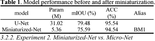
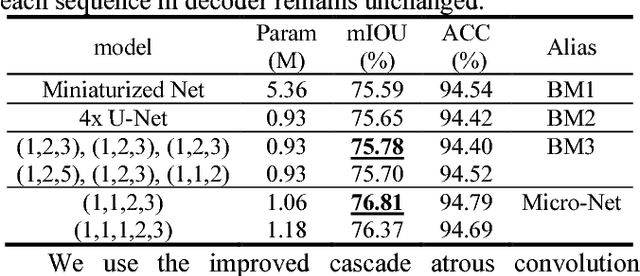
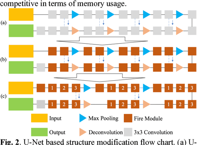
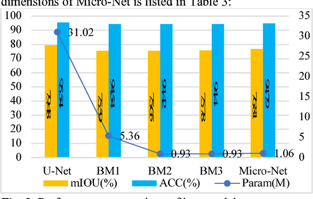
In order to save the memory, we propose a miniaturization method for neural network to reduce the parameter quantity existed in remote sensing (RS) image semantic segmentation model. The compact convolution optimization method is first used for standard U-Net to reduce the weights quantity. With the purpose of decreasing model performance loss caused by miniaturization and based on the characteristics of remote sensing image, fewer down-samplings and improved cascade atrous convolution are then used to improve the performance of the miniaturized U-Net. Compared with U-Net, our proposed Micro-Net not only achieves 29.26 times model compression, but also basically maintains the performance unchanged on the public dataset. We provide a Keras and Tensorflow hybrid programming implementation for our model: https://github.com/Isnot2bad/Micro-Net