 Add to Chrome
 Add to Firefox
 Add to Edge
SCAPE: Scenario-Conditioned Simulation-Augmented Policy Evaluation
Aug 19, 2026
Reliable performance evaluation is a central bottleneck for deploying robot-learning policies in real-world conditions. Real-world testing is faithful but costly and difficult to scale, whereas simulation-based testing scales easily but is inevitably biased by the sim-to-real gap. Existing simulation-augmented methods combine limited real-world rollouts with abundant simulation proxies, but focus on performance averaged over initial conditions and deployment settings. Such population-level averages obscure scenario-specific variation and provide limited guidance about when and where a policy can be safely deployed. We propose SCAPE, a scenario-conditioned simulation-augmented policy evaluation framework that predicts scenario-conditioned real-world policy performance using limited paired sim-and-real samples and large-scale simulation rollouts. SCAPE corrects sim-to-real bias in simulation labels before training the prediction model and calibrates prediction uncertainty through conformal prediction. We validate SCAPE on autonomous driving and quadruped velocity tracking. In sim-to-sim studies, SCAPE reduces scenario-level prediction error by 4.9%/34.7% (driving) and 14.5%/27.7% (quadruped) relative to scene-conditioned neural and aggregate statistical baselines on average. We further evaluate a velocity-tracking policy deployed on a physical Unitree Go2. SCAPE also improves testing sample efficiency, produces narrower calibrated prediction intervals, generalizes better to out-of-distribution scenarios, and enables fine-grained deployment strategies.

Attention Frequency Modulation: Training-Free Spectral Modulation of Diffusion Cross-Attention
Mar 30, 2026Cross-attention is the primary interface through which text conditions latent diffusion models, yet its step-wise multi-resolution dynamics remain under-characterized, limiting principled training-free control. We cast diffusion cross-attention as a spatiotemporal signal on the latent grid by summarizing token-softmax weights into token-agnostic concentration maps and tracking their radially binned Fourier power over denoising. Across prompts and seeds, encoder cross-attention exhibits a consistent coarse-to-fine spectral progression, yielding a stable time-frequency fingerprint of token competition. Building on this structure, we introduce Attention Frequency Modulation (AFM), a plug-and-play inference-time intervention that edits token-wise pre-softmax cross-attention logits in the Fourier domain: low- and high-frequency bands are reweighted with a progress-aligned schedule and can be adaptively gated by token-allocation entropy, before the token softmax. AFM provides a continuous handle to bias the spatial scale of token-competition patterns without retraining, prompt editing, or parameter updates. Experiments on Stable Diffusion show that AFM reliably redistributes attention spectra and produces substantial visual edits while largely preserving semantic alignment. Finally, we find that entropy mainly acts as an adaptive gain on the same frequency-based edit rather than an independent control axis.
The City that Never Settles: Simulation-based LiDAR Dataset for Long-Term Place Recognition Under Extreme Structural Changes
May 08, 2025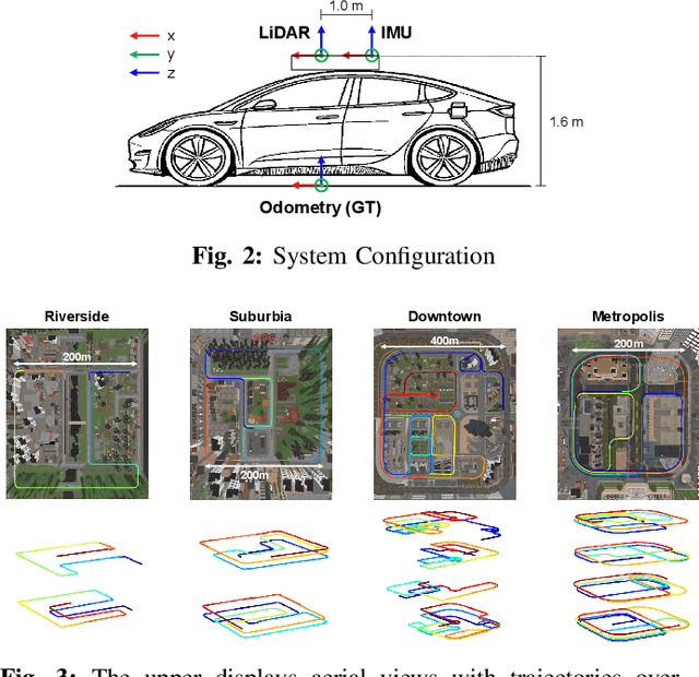
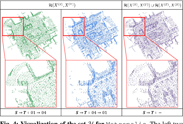
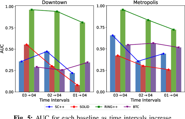
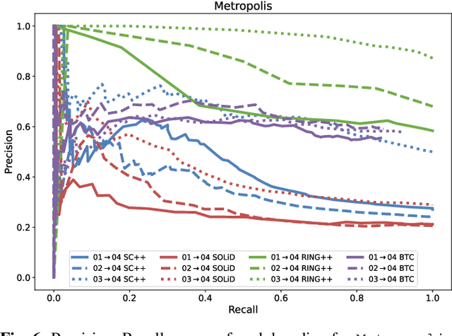
Large-scale construction and demolition significantly challenge long-term place recognition (PR) by drastically reshaping urban and suburban environments. Existing datasets predominantly reflect limited or indoor-focused changes, failing to adequately represent extensive outdoor transformations. To bridge this gap, we introduce the City that Never Settles (CNS) dataset, a simulation-based dataset created using the CARLA simulator, capturing major structural changes-such as building construction and demolition-across diverse maps and sequences. Additionally, we propose TCR_sym, a symmetric version of the original TCR metric, enabling consistent measurement of structural changes irrespective of source-target ordering. Quantitative comparisons demonstrate that CNS encompasses more extensive transformations than current real-world benchmarks. Evaluations of state-of-the-art LiDAR-based PR methods on CNS reveal substantial performance degradation, underscoring the need for robust algorithms capable of handling significant environmental changes. Our dataset is available at https://github.com/Hyunho111/CNS_dataset.
Quantitative 3D Map Accuracy Evaluation Hardware and Algorithm for LiDAR(-Inertial) SLAM
Aug 19, 2024Accuracy evaluation of a 3D pointcloud map is crucial for the development of autonomous driving systems. In this work, we propose a user-independent software/hardware system that can quantitatively evaluate the accuracy of a 3D pointcloud map acquired from LiDAR(-Inertial) SLAM. We introduce a LiDAR target that functions robustly in the outdoor environment, while remaining observable by LiDAR. We also propose a software algorithm that automatically extracts representative points and calculates the accuracy of the 3D pointcloud map by leveraging GPS position data. This methodology overcomes the limitations of the manual selection method, that its result varies between users. Furthermore, two different error metrics, relative and absolute errors, are introduced to analyze the accuracy from different perspectives. Our implementations are available at: https://github.com/SangwooJung98/3D_Map_Evaluation