 Add to Chrome
 Add to Firefox
 Add to Edge
AppleScab-LT: A Longitudinal Real-Field Apple Scab Dataset for Temporal Disease Progression Analysis
Aug 14, 2026
The development of reliable plant disease monitoring systems is constrained by limited longitudinal datasets capturing disease progression under natural field conditions. Although existing plant disease datasets have advanced image-based recognition, most consist of static images acquired at a single time point, limiting analysis of temporal disease evolution and severity progression. To address this gap, this study presents AppleScab-LT, a longitudinal real-field dataset developed to monitor apple scab progression through repeated observations of individually tracked infected leaves. Guided by a research-question-driven framework, the dataset was systematically developed, validated, and characterized for reliable longitudinal disease analysis. AppleScab-LT was constructed through systematic orchard monitoring under natural environmental conditions, incorporating longitudinal leaf tracking, expert-guided disease verification, polygon-based annotation, leaf isolation, disease severity quantification, and temporal sequence construction. A comprehensive quality assurance framework, including standardized annotation protocols, expert validation, automated integrity checks, sequence-level verification, and temporal consistency analysis, was applied throughout curation. The dataset contains 21 longitudinal leaf sequences, 2,101 high-resolution images, and 264 progressive temporal samples from repeated monitoring of same infected leaves. It captures variability in severity accumulation, progression rates, monitoring duration, and inter-leaf progression. Quantitative disease descriptors based on pixel severity, color-intensity severity, and normalized relative severity provide standardized measurements for temporal disease analysis. AppleScab-LT provides a reliable resource for temporal disease intelligence, disease progression modelling, precision agriculture, and future crop health monitoring

STS-NET: Spatio-Temporal Stress Network for Self-Supervised Crop Stress Detection using Satellite Image Time Series
Jul 21, 2026Early and accurate detection of crop stress is essential to improve agricultural productivity and ensure global food security. However, collecting a large labeled crop stress dataset is a challenging task. To address this challenge, we introduce a novel spatial-temporal stress network (STS-NET), built on a self-supervised 3D-convolutional autoencoder (3D-CAE), designed to utilize Satellite Image Time Series (SITS) data for crop stress detection. STS-NET exploits four vegetation indices: Normalized Difference Vegetation Index (NDVI), Normalized Difference Vegetation Index (GNDVI), Red-Edge Chlorophyll Index (RECI) and Normalized Difference Red-Edge Index (NDRE) obtained from high resolution Planetscope imagery to capture spatiotemporal stress patterns. The model is trained on our BSPT (Barnala Spatial-Temporal) dataset and evaluated on a real-world sugarcane dataset collected over a year from a 2.5-acre test plot located in Lakhimpur-Kheri (LK) district in Uttar Pradesh in India. STS-NET achieved a precision of 97. 98\% for water stress, 85.08\% for nitrogen stress, and 83.47\% for combined stress. The results demonstrate the potential of STS-NET in effectively detecting stress in sugarcane crops with minimal reliance on labeled data. Furthermore, STS-NET can serve as a robust feature extractor for simpler models.
An End-to-End Framework for Dynamic Crime Profiling of Places
Nov 20, 2021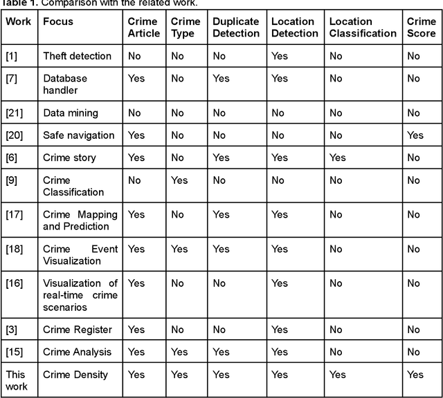
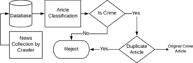
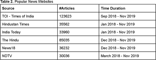

Much effort is being made to ensure the safety of people. One of the main requirements of travellers and city administrators is to have knowledge of places that are more prone to criminal activities. To rate a place as a potential crime location, it needs the past crime history at that location. Such data is not easily available in the public domain, however, it floats around on the Internet in the form of newspaper and social media posts, in an unstructured manner though. Consequently, a large number of works are reported on extracting crime information from news articles, providing piecemeal solutions to the problem. This chapter complements these works by building an end-to-end framework for crime profiling of any given location/area. It customizes individual components of the framework and provides a Spatio-temporal integration of crime information. It develops an automated framework that crawls online news articles, analyzes them, and extracts relevant information to create a crime knowledge base that gets dynamically updated in real-time. The crime density can be easily visualized in the form of a heat map which is generated by the knowledge base. As a case study, it investigates 345448 news articles published by 6 daily English newspapers collected for approximately two years. Experimental results show that the crime profiling matches with the ratings calculated manually by various organizations.
High-Throughput CNN Inference on Embedded ARM big.LITTLE Multi-Core Processors
Mar 14, 2019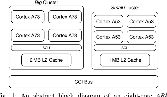
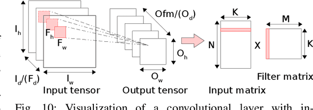
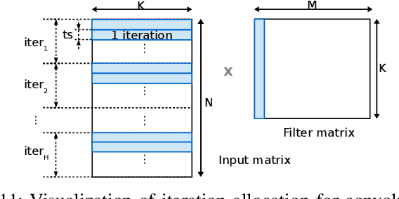
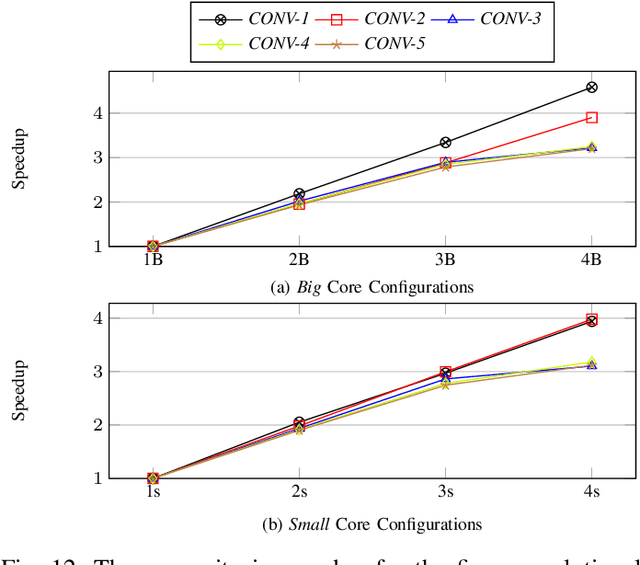
IoT Edge intelligence requires Convolutional Neural Network (CNN) inference to take place in the edge device itself. ARM big.LITTLE architecture is at the heart of common commercial edge devices. It comprises of single-ISA heterogeneous multi-cores grouped in homogeneous clusters that enables performance and power trade-offs. However, high communication overhead involved in parallelization of computation from a convolution kernel across clusters is detrimental to throughput. We present an alternative framework called Pipe-it that employs a pipelined design to split the convolutional layers across clusters while limiting the parallelization of their respective kernels to the assigned clusters. We develop a performance prediction model that, from convolutional layer descriptors, predicts the execution time of each layer individually on all different core types and number of cores. Pipe-it then exploits the predictions to create a balanced pipeline using an efficient design space exploration algorithm. Pipe-it on average results in 39% higher throughput than the highest antecedent throughput.