 Add to Chrome
 Add to Firefox
 Add to Edge
Methods for evaluating the resolution of 3D data derived from satellite images
Jun 13, 20253D data derived from satellite images is essential for scene modeling applications requiring large-scale coverage or involving locations not accessible by airborne lidar or cameras. Measuring the resolution of this data is important for determining mission utility and tracking improvements. In this work, we consider methods to evaluate the resolution of point clouds, digital surface models, and 3D mesh models. We describe 3D metric evaluation tools and workflows that enable automated evaluation based on high-resolution reference airborne lidar, and we present results of analyses with data of varying quality.
Unconstrained Large-scale 3D Reconstruction and Rendering across Altitudes
Apr 29, 2025Production of photorealistic, navigable 3D site models requires a large volume of carefully collected images that are often unavailable to first responders for disaster relief or law enforcement. Real-world challenges include limited numbers of images, heterogeneous unposed cameras, inconsistent lighting, and extreme viewpoint differences for images collected from varying altitudes. To promote research aimed at addressing these challenges, we have developed the first public benchmark dataset for 3D reconstruction and novel view synthesis based on multiple calibrated ground-level, security-level, and airborne cameras. We present datasets that pose real-world challenges, independently evaluate calibration of unposed cameras and quality of novel rendered views, demonstrate baseline performance using recent state-of-practice methods, and identify challenges for further research.
Cumulative Assessment for Urban 3D Modeling
Jul 09, 2021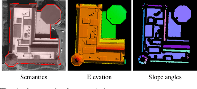
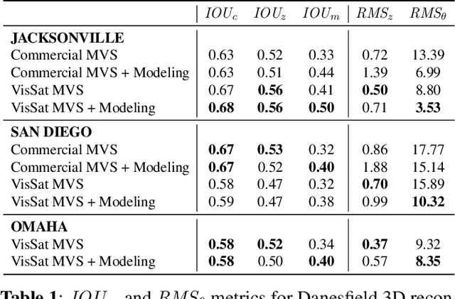
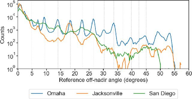
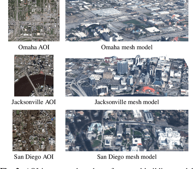
Urban 3D modeling from satellite images requires accurate semantic segmentation to delineate urban features, multiple view stereo for 3D reconstruction of surface heights, and 3D model fitting to produce compact models with accurate surface slopes. In this work, we present a cumulative assessment metric that succinctly captures error contributions from each of these components. We demonstrate our approach by providing challenging public datasets and extending two open source projects to provide an end-to-end 3D modeling baseline solution to stimulate further research and evaluation with a public leaderboard.
Semantic Stereo for Incidental Satellite Images
Nov 21, 2018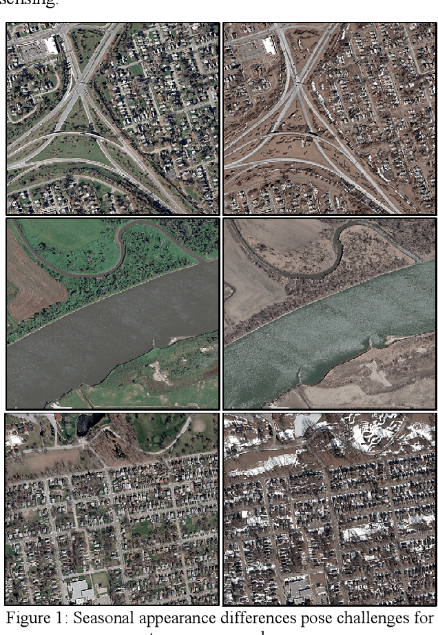
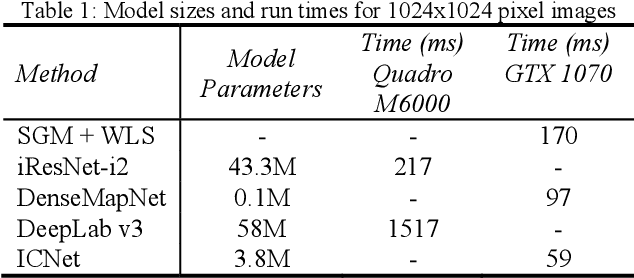
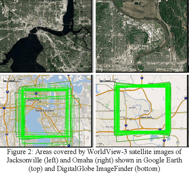
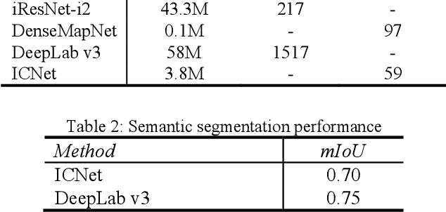
The increasingly common use of incidental satellite images for stereo reconstruction versus rigidly tasked binocular or trinocular coincident collection is helping to enable timely global-scale 3D mapping; however, reliable stereo correspondence from multi-date image pairs remains very challenging due to seasonal appearance differences and scene change. Promising recent work suggests that semantic scene segmentation can provide a robust regularizing prior for resolving ambiguities in stereo correspondence and reconstruction problems. To enable research for pairwise semantic stereo and multi-view semantic 3D reconstruction with incidental satellite images, we have established a large-scale public dataset including multi-view, multi-band satellite images and ground truth geometric and semantic labels for two large cities. To demonstrate the complementary nature of the stereo and segmentation tasks, we present lightweight public baselines adapted from recent state of the art convolutional neural network models and assess their performance.