 Add to Chrome
 Add to Firefox
 Add to Edge
AerialFusionMapNet: Online HD Map Construction with Aerial-Onboard BEV Fusion
Jun 23, 2026
High-resolution aerial imagery has recently emerged as a complementary modality for automated driving perception and has shown potential to improve birds-eye-view (BEV) scene understanding when fused with onboard sensors. Prior work demonstrated performance gains for online high-definition (HD) map construction through aerial-onboard fusion; however, conventional end-to-end fusion does not fully exploit the structural information contained in aerial representations. In this work, we introduce AerialFusionMapNet, a fusion-based mapping framework with a structured two-stage training strategy that explicitly enhances the contribution of aerial features within a unified pipeline. The proposed training scheme enables more effective integration of structural aerial priors. On the nuScenes geographic split, AerialFusionMapNet achieves up to 54.7 mAP, improving over prior aerial-onboard fusion baselines from 48.8 mAP by +5.9 absolute and +12.1% relative. The results suggest that structured training design, rather than increased architectural complexity, plays a more decisive role in unlocking the full potential of aerial imagery for online HD map construction. Code and trained models are available at https://github.com/DriverlessMobility/AerialFusionMapNet.

Learning Ego-Centric BEV Representations from a Perspective-Privileged View: Cross-View Supervision for Online HD Map Construction
May 12, 2026Bird's-eye-view (BEV) representations derived from multi-camera input have become a central interface for online high-definition (HD) map construction. However, most approaches rely solely on ego-centric supervision, requiring large-scale scene structure to be inferred from incomplete observations, occlusions, and diminishing information density at long range, where perspective effects and spatial sparsity hinder consistent structural reasoning. We introduce Cross-View Supervision (CVS), a representation learning paradigm that transfers geometric and topological priors from an ego-aligned overhead perspective into camera-based BEV encoders. Rather than adding auxiliary semantic losses, CVS aligns representations in a shared BEV feature space and distills globally consistent structural knowledge from a perspective-privileged teacher into the ego-centric backbone. This supervision enhances structural coherence without modifying the inference architecture or requiring overhead input at test time. Experiments on nuScenes using ego-aligned aerial imagery from the AID4AD cross-view extension demonstrate consistent improvements over StreamMapNet while maintaining identical camera-only inference. CVS yields +3.9\,mAP in the standard $60\times30\,\mathrm{m}$ region and +9.9\,mAP in the extended $100\times50\,\mathrm{m}$ setting, corresponding to a 44\% relative gain at long range. These results highlight perspective-privileged structural supervision as a promising training principle for improving BEV representation learning in HD map construction.
TUM2TWIN: Introducing the Large-Scale Multimodal Urban Digital Twin Benchmark Dataset
May 13, 2025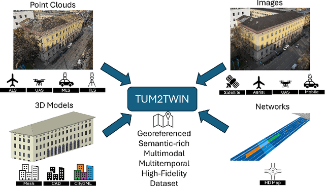
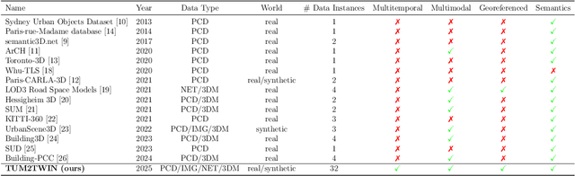
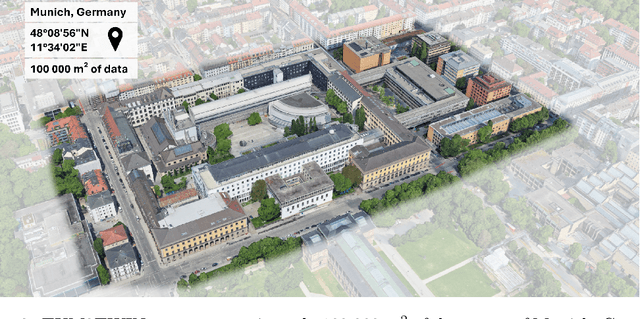
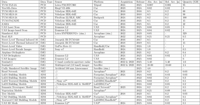
Urban Digital Twins (UDTs) have become essential for managing cities and integrating complex, heterogeneous data from diverse sources. Creating UDTs involves challenges at multiple process stages, including acquiring accurate 3D source data, reconstructing high-fidelity 3D models, maintaining models' updates, and ensuring seamless interoperability to downstream tasks. Current datasets are usually limited to one part of the processing chain, hampering comprehensive UDTs validation. To address these challenges, we introduce the first comprehensive multimodal Urban Digital Twin benchmark dataset: TUM2TWIN. This dataset includes georeferenced, semantically aligned 3D models and networks along with various terrestrial, mobile, aerial, and satellite observations boasting 32 data subsets over roughly 100,000 $m^2$ and currently 767 GB of data. By ensuring georeferenced indoor-outdoor acquisition, high accuracy, and multimodal data integration, the benchmark supports robust analysis of sensors and the development of advanced reconstruction methods. Additionally, we explore downstream tasks demonstrating the potential of TUM2TWIN, including novel view synthesis of NeRF and Gaussian Splatting, solar potential analysis, point cloud semantic segmentation, and LoD3 building reconstruction. We are convinced this contribution lays a foundation for overcoming current limitations in UDT creation, fostering new research directions and practical solutions for smarter, data-driven urban environments. The project is available under: https://tum2t.win