 Add to Chrome
 Add to Firefox
 Add to Edge
Diffuse the object, keep its label: curating detector training data from a few unlabeled photographs via VLM-built 3D vegetation scenes
Aug 10, 2026
Labeled images of small objects hidden in vegetation are scarce, and detectors trained on them generalize poorly across sites. Rather than reusing labels collected at another site, we synthesize labeled training images from a handful of unlabeled photographs of the deployment site itself. A vision--language model generates a coarse 3D vegetation scene from one photograph; placing 3D object meshes in the scene yields bounding boxes, segmentation masks, and per-instance occlusion directly from the scene geometry, without manual annotation. A lightweight adapter fine-tuned on the photographs conditions a diffusion pass that re-textures the renders, and a graded mask-lock sets how much diffusion may touch the object itself. In our runs this grade was the most influential curation choice: lightly diffusing the object improves minority-class recall over fully protecting its pixels, while unrestricted diffusion dissolves it. Trained on these images, a standard detector matched or exceeded its counterpart trained on a larger labeled dataset of real images from a different site, consistently across seeds on a humanitarian-demining benchmark; the comparison is thus unsupervised site adaptation from a handful of photographs against conventional cross-site label reuse. In our ablations the gains were largely insensitive to the photograph and crop budgets, and in-domain accuracy did not predict cross-site performance.

MineInsight: A Multi-sensor Dataset for Humanitarian Demining Robotics in Off-Road Environments
Jun 05, 2025The use of robotics in humanitarian demining increasingly involves computer vision techniques to improve landmine detection capabilities. However, in the absence of diverse and realistic datasets, the reliable validation of algorithms remains a challenge for the research community. In this paper, we introduce MineInsight, a publicly available multi-sensor, multi-spectral dataset designed for off-road landmine detection. The dataset features 35 different targets (15 landmines and 20 commonly found objects) distributed along three distinct tracks, providing a diverse and realistic testing environment. MineInsight is, to the best of our knowledge, the first dataset to integrate dual-view sensor scans from both an Unmanned Ground Vehicle and its robotic arm, offering multiple viewpoints to mitigate occlusions and improve spatial awareness. It features two LiDARs, as well as images captured at diverse spectral ranges, including visible (RGB, monochrome), visible short-wave infrared (VIS-SWIR), and long-wave infrared (LWIR). Additionally, the dataset comes with an estimation of the location of the targets, offering a benchmark for evaluating detection algorithms. We recorded approximately one hour of data in both daylight and nighttime conditions, resulting in around 38,000 RGB frames, 53,000 VIS-SWIR frames, and 108,000 LWIR frames. MineInsight serves as a benchmark for developing and evaluating landmine detection algorithms. Our dataset is available at https://github.com/mariomlz99/MineInsight.
HADRON: Human-friendly Control and Artificial Intelligence for Military Drone Operations
Aug 13, 2024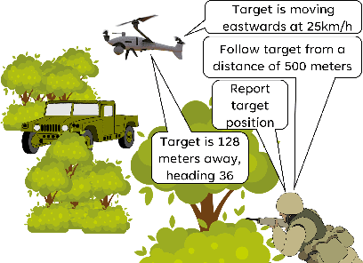
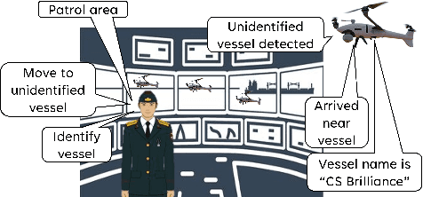
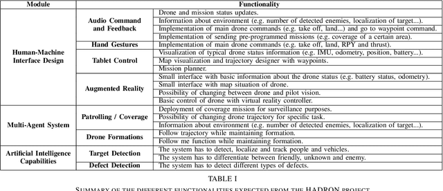
As drones are getting more and more entangled in our society, more untrained users require the capability to operate them. This scenario is to be achieved through the development of artificial intelligence capabilities assisting the human operator in controlling the Unmanned Aerial System (UAS) and processing the sensor data, thereby alleviating the need for extensive operator training. This paper presents the HADRON project that seeks to develop and test multiple novel technologies to enable human-friendly control of drone swarms. This project is divided into three main parts. The first part consists of the integration of different technologies for the intuitive control of drones, focusing on novice or inexperienced pilots and operators. The second part focuses on the development of a multi-drone system that will be controlled from a command and control station, in which an expert pilot can supervise the operations of the multiple drones. The third part of the project will focus on reducing the cognitive load on human operators, whether they are novice or expert pilots. For this, we will develop AI tools that will assist drone operators with semi-automated real-time data processing.
A multi-robot system for the detection of explosive devices
Apr 22, 2024In order to clear the world of the threat posed by landmines and other explosive devices, robotic systems can play an important role. However, the development of such field robots that need to operate in hazardous conditions requires the careful consideration of multiple aspects related to the perception, mobility, and collaboration capabilities of the system. In the framework of a European challenge, the Artificial Intelligence for Detection of Explosive Devices - eXtended (AIDEDeX) project proposes to design a heterogeneous multi-robot system with advanced sensor fusion algorithms. This system is specifically designed to detect and classify improvised explosive devices, explosive ordnances, and landmines. This project integrates specialised sensors, including electromagnetic induction, ground penetrating radar, X-Ray backscatter imaging, Raman spectrometers, and multimodal cameras, to achieve comprehensive threat identification and localisation. The proposed system comprises a fleet of unmanned ground vehicles and unmanned aerial vehicles. This article details the operational phases of the AIDEDeX system, from rapid terrain exploration using unmanned aerial vehicles to specialised detection and classification by unmanned ground vehicles equipped with a robotic manipulator. Initially focusing on a centralised approach, the project will also explore the potential of a decentralised control architecture, taking inspiration from swarm robotics to provide a robust, adaptable, and scalable solution for explosive detection.