 Add to Chrome
 Add to Firefox
 Add to Edge
deSEO: Physics-Aware Dataset Creation for High-Resolution Satellite Image Shadow Removal
May 05, 2026
Shadows cast by terrain and tall structures remain a major obstacle for high-resolution satellite image analysis, degrading classification, detection, and 3D reconstruction performance. Public resources offering geometry-consistent paired shadow/shadow-free satellite imagery are essentially missing, and most Earth-observation datasets are designed for shadow detection or 3D modelling rather than removal. Existing deep shadow-removal datasets either target ground-level or aerial scenes or rely on unpaired and weakly supervised formulations rather than explicit satellite pairs. We address this gap with deSEO, a geometry-aware and physics-informed methodology that, to the best of our knowledge, is the first to derive paired supervision for satellite shadow removal from the S-EO shadow detection dataset through a fully replicable pipeline. For each tile, deSEO selects a minimally shadowed acquisition as a weak reference and pairs it with shadowed counterparts using temporal and geometric filtering, Jacobian-based orientation normalisation, and LoFTR-RANSAC registration. A per-pixel validity mask restricts learning to reliably aligned regions, enabling supervision despite residual off-nadir parallax. In addition to this paired dataset, we develop a DSM-aware deshadowing model that combines residual translation, perceptual objectives, and mask-constrained adversarial learning. In contrast, a direct adaptation of a UAV-based SRNet/pix2pix architecture fails to converge under satellite viewpoint variability. Our model consistently reduces the visual impact of cast shadows across diverse illumination and viewing conditions, achieving improved structural and perceptual fidelity on held-out scenes. deSEO therefore provides the first reproducible, geometry-aware paired dataset and baseline for shadow removal in satellite Earth observation.

DirPA: Addressing Prior Shift in Imbalanced Few-shot Crop-type Classification
Mar 13, 2026Real-world agricultural monitoring is often hampered by severe class imbalance and high label acquisition costs, resulting in significant data scarcity. In few-shot learning (FSL) -- a framework specifically designed for data-scarce settings -- , training sets are often artificially balanced. However, this creates a disconnect from the long-tailed distributions observed in nature, leading to a distribution shift that undermines the model's ability to generalize to real-world agricultural tasks. We previously introduced Dirichlet Prior Augmentation (DirPA; Reuss et al., 2026a) to proactively mitigate the effects of such label distribution skews during model training. In this work, we extend the original study's geographical scope. Specifically, we evaluate this extended approach across multiple countries in the European Union (EU), moving beyond localized experiments to test the method's resilience across diverse agricultural environments. Our results demonstrate the effectiveness of DirPA across different geographical regions. We show that DirPA not only improves system robustness and stabilizes training under extreme long-tailed distributions, regardless of the target region, but also substantially improves individual class-specific performance by proactively simulating priors.
Meta-learning For Few-Shot Time Series Crop Type Classification: A Benchmark On The EuroCropsML Dataset
Apr 15, 2025Spatial imbalances in crop type data pose significant challenges for accurate classification in remote sensing applications. Algorithms aiming at transferring knowledge from data-rich to data-scarce tasks have thus surged in popularity. However, despite their effectiveness in previous evaluations, their performance in challenging real-world applications is unclear and needs to be evaluated. This study benchmarks transfer learning and several meta-learning algorithms, including (First-Order) Model-Agnostic Meta-Learning ((FO)-MAML), Almost No Inner Loop (ANIL), and Task-Informed Meta-Learning (TIML), on the real-world EuroCropsML time series dataset, which combines farmer-reported crop data with Sentinel-2 satellite observations from Estonia, Latvia, and Portugal. Our findings indicate that MAML-based meta-learning algorithms achieve slightly higher accuracy compared to simpler transfer learning methods when applied to crop type classification tasks in Estonia after pre-training on data from Latvia. However, this improvement comes at the cost of increased computational demands and training time. Moreover, we find that the transfer of knowledge between geographically disparate regions, such as Estonia and Portugal, poses significant challenges to all investigated algorithms. These insights underscore the trade-offs between accuracy and computational resource requirements in selecting machine learning methods for real-world crop type classification tasks and highlight the difficulties of transferring knowledge between different regions of the Earth. To facilitate future research in this domain, we present the first comprehensive benchmark for evaluating transfer and meta-learning methods for crop type classification under real-world conditions. The corresponding code is publicly available at https://github.com/dida-do/eurocrops-meta-learning.
EuroCropsML: A Time Series Benchmark Dataset For Few-Shot Crop Type Classification
Jul 24, 2024


We introduce EuroCropsML, an analysis-ready remote sensing machine learning dataset for time series crop type classification of agricultural parcels in Europe. It is the first dataset designed to benchmark transnational few-shot crop type classification algorithms that supports advancements in algorithmic development and research comparability. It comprises 706 683 multi-class labeled data points across 176 classes, featuring annual time series of per-parcel median pixel values from Sentinel-2 L1C data for 2021, along with crop type labels and spatial coordinates. Based on the open-source EuroCrops collection, EuroCropsML is publicly available on Zenodo.
Harnessing Administrative Data Inventories to Create a Reliable Transnational Reference Database for Crop Type Monitoring
Oct 10, 2023With leaps in machine learning techniques and their applicationon Earth observation challenges has unlocked unprecedented performance across the domain. While the further development of these methods was previously limited by the availability and volume of sensor data and computing resources, the lack of adequate reference data is now constituting new bottlenecks. Since creating such ground-truth information is an expensive and error-prone task, new ways must be devised to source reliable, high-quality reference data on large scales. As an example, we showcase E URO C ROPS, a reference dataset for crop type classification that aggregates and harmonizes administrative data surveyed in different countries with the goal of transnational interoperability.
XAI for Early Crop Classification
Oct 10, 2023


We propose an approach for early crop classification through identifying important timesteps with eXplainable AI (XAI) methods. Our approach consists of training a baseline crop classification model to carry out layer-wise relevance propagation (LRP) so that the salient time step can be identified. We chose a selected number of such important time indices to create the bounding region of the shortest possible classification timeframe. We identified the period 21st April 2019 to 9th August 2019 as having the best trade-off in terms of accuracy and earliness. This timeframe only suffers a 0.75% loss in accuracy as compared to using the full timeseries. We observed that the LRP-derived important timesteps also highlight small details in input values that differentiates between different classes and
EuroCrops: A Pan-European Dataset for Time Series Crop Type Classification
Jun 14, 2021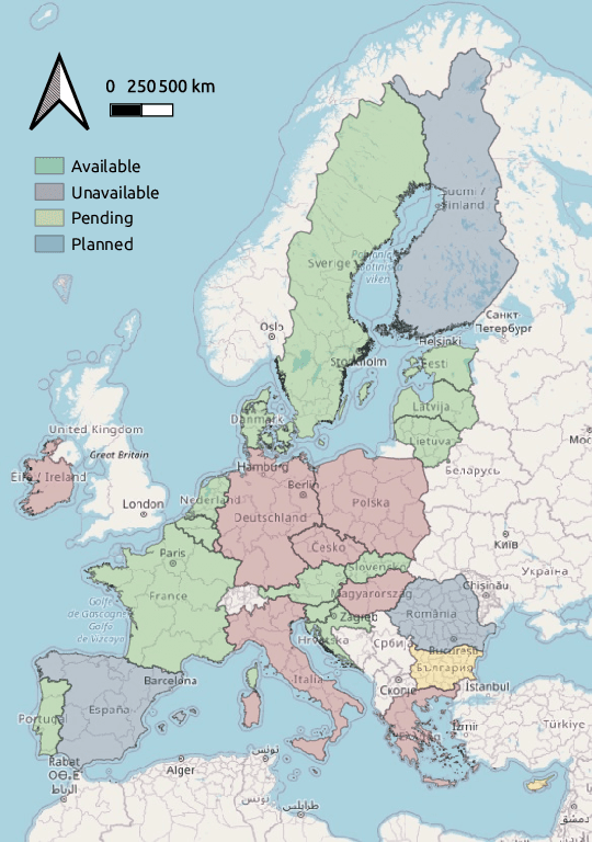
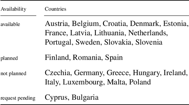
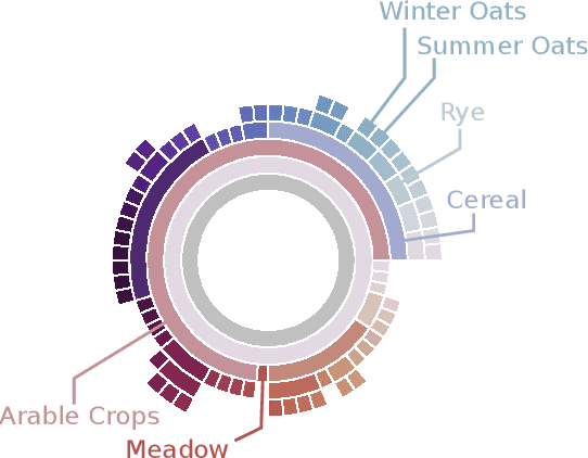
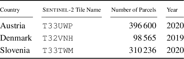
We present EuroCrops, a dataset based on self-declared field annotations for training and evaluating methods for crop type classification and mapping, together with its process of acquisition and harmonisation. By this, we aim to enrich the research efforts and discussion for data-driven land cover classification via Earth observation and remote sensing. Additionally, through inclusion of self-declarations gathered in the scope of subsidy control from all countries of the European Union (EU), this dataset highlights the difficulties and pitfalls one comes across when operating on a transnational level. We, therefore, also introduce a new taxonomy scheme, HCAT-ID, that aspires to capture all the aspects of reference data originating from administrative and agency databases. To address researchers from both the remote sensing and the computer vision and machine learning communities, we publish the dataset in different formats and processing levels.
* 4 pages, website: https://www.eurocrops.tum.de/
Multi-task Learning for Human Settlement Extent Regression and Local Climate Zone Classification
Nov 23, 2020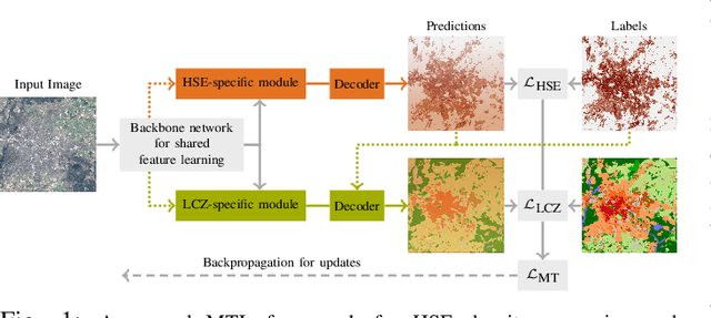
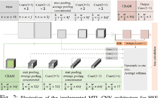
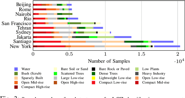
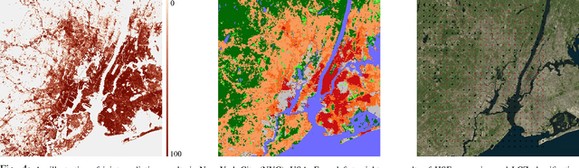
Human Settlement Extent (HSE) and Local Climate Zone (LCZ) maps are both essential sources, e.g., for sustainable urban development and Urban Heat Island (UHI) studies. Remote sensing (RS)- and deep learning (DL)-based classification approaches play a significant role by providing the potential for global mapping. However, most of the efforts only focus on one of the two schemes, usually on a specific scale. This leads to unnecessary redundancies, since the learned features could be leveraged for both of these related tasks. In this letter, the concept of multi-task learning (MTL) is introduced to HSE regression and LCZ classification for the first time. We propose a MTL framework and develop an end-to-end Convolutional Neural Network (CNN), which consists of a backbone network for shared feature learning, attention modules for task-specific feature learning, and a weighting strategy for balancing the two tasks. We additionally propose to exploit HSE predictions as a prior for LCZ classification to enhance the accuracy. The MTL approach was extensively tested with Sentinel-2 data of 13 cities across the world. The results demonstrate that the framework is able to provide a competitive solution for both tasks.
Meta-Learning for Few-Shot Land Cover Classification
Apr 28, 2020


The representations of the Earth's surface vary from one geographic region to another. For instance, the appearance of urban areas differs between continents, and seasonality influences the appearance of vegetation. To capture the diversity within a single category, like as urban or vegetation, requires a large model capacity and, consequently, large datasets. In this work, we propose a different perspective and view this diversity as an inductive transfer learning problem where few data samples from one region allow a model to adapt to an unseen region. We evaluate the model-agnostic meta-learning (MAML) algorithm on classification and segmentation tasks using globally and regionally distributed datasets. We find that few-shot model adaptation outperforms pre-training with regular gradient descent and fine-tuning on (1) the Sen12MS dataset and (2) DeepGlobe data when the source domain and target domain differ. This indicates that model optimization with meta-learning may benefit tasks in the Earth sciences whose data show a high degree of diversity from region to region, while traditional gradient-based supervised learning remains suitable in the absence of a feature or label shift.
A Generalized Multi-Task Learning Approach to Stereo DSM Filtering in Urban Areas
Apr 07, 2020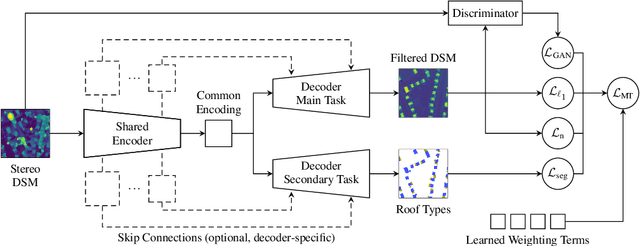
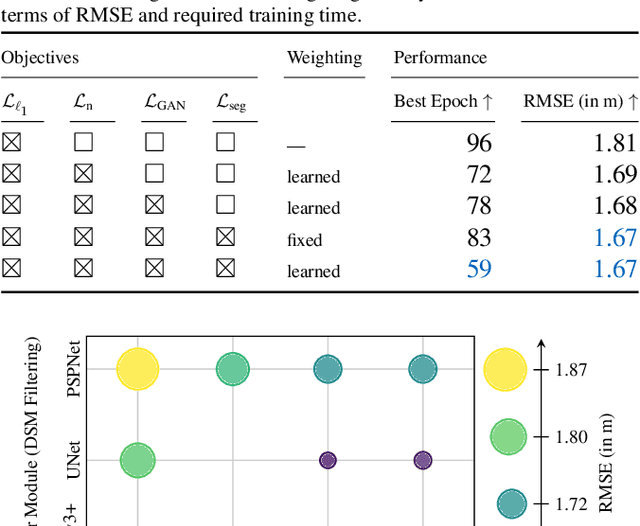
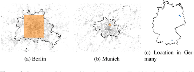
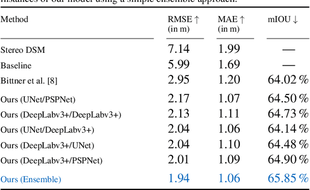
City models and height maps of urban areas serve as a valuable data source for numerous applications, such as disaster management or city planning. While this information is not globally available, it can be substituted by digital surface models (DSMs), automatically produced from inexpensive satellite imagery. However, stereo DSMs often suffer from noise and blur. Furthermore, they are heavily distorted by vegetation, which is of lesser relevance for most applications. Such basic models can be filtered by convolutional neural networks (CNNs), trained on labels derived from digital elevation models (DEMs) and 3D city models, in order to obtain a refined DSM. We propose a modular multi-task learning concept that consolidates existing approaches into a generalized framework. Our encoder-decoder models with shared encoders and multiple task-specific decoders leverage roof type classification as a secondary task and multiple objectives including a conditional adversarial term. The contributing single-objective losses are automatically weighted in the final multi-task loss function based on learned uncertainty estimates. We evaluated the performance of specific instances of this family of network architectures. Our method consistently outperforms the state of the art on common data, both quantitatively and qualitatively, and generalizes well to a new dataset of an independent study area.