 Add to Chrome
 Add to Firefox
 Add to Edge
RRT-Rope: A deterministic shortening approach for fast near-optimal path planning in large-scale uncluttered 3D environments
Jun 30, 2026
Many path planning algorithms have been introduced so far, but most are costly, in path cost and in processing time, in large-scale uncluttered 3D environments such as underground mining stopes explored by an unmanned aerial vehicle (UAV). Rapidly-exploring Random Tree (RRT) algorithms are popular because of their probabilistic completeness and rapidity in finding a feasible path in single-query problems. Many of the algorithms (e.g. Informed RRT*, RRT#) developed to improve RRT need considerable time to converge in large environments. Shortcutting an RRT is an old idea that has been proven to outperform RRT variants. This paper introduces a new method, RRT-Rope, that aims at finding a near-optimal solution in a drastically shorter amount of time. The proposed approach benefits from fast computation of a feasible path with an altered version of RRT-connect, and post-processes it quickly with a deterministic shortcutting technique, taking advantage of intermediate nodes added to each branch of the tree. This paper presents simulations and statistics carried out to show the efficiency of RRT-Rope, which gives better results in terms of path cost and computation time than other popular RRT variations and shortening techniques in all our simulation environments, and is up to 70% faster than the next best algorithm in a representative stope.
* 8 pages, accepted at the 2021 IEEE International Conference on Systems, Man, and Cybernetics (SMC), Melbourne, Australia

MOAR Planner: Multi-Objective and Adaptive Risk-Aware Path Planning for Infrastructure Inspection with a UAV
Jun 29, 2026The problem of autonomous navigation for UAV inspection remains challenging as it requires effectively navigating in close proximity to obstacles, while accounting for dynamic risk factors such as weather conditions, communication reliability, and battery autonomy. This paper introduces the MOAR path planner which addresses the complexities of evolving risks during missions. It offers real-time trajectory adaptation while concurrently optimizing safety, time, and energy. The planner employs a risk-aware cost function that integrates pre-computed cost maps, the new concepts of damage and insertion costs, and an adaptive speed planning framework. With that, the optimal path is searched in a graph using a discrete representation of the state and action spaces. The method is evaluated through simulations and real-world flight tests. The results show the capability to generate real-time trajectories spanning a broad range of evaluation metrics: around 90% of the range occupied by popular algorithms. The proposed framework contributes by enabling UAVs to navigate more autonomously and reliably in critical missions.
* 7 pages, accepted at the 2024 IEEE International Conference on Robotics and Automation (ICRA), Yokohama, Japan
TAPE: Tether-Aware Path Planning for Autonomous Exploration of Unknown 3D Cavities Using a Tangle-Compatible Tethered Aerial Robot
Jun 29, 2026This letter presents the first method for autonomous exploration of unknown cavities in three dimensions (3D) that focuses on minimizing the distance traveled and the length of tether unwound. Considering that the tether entanglements are little influenced by the global path, our approach employs a 2-level hierarchical architecture. The global frontier-based planning solves a Traveling Salesman Problem (TSP) to minimize the distance. The local planning attempts to minimize the path cost and the tether length using an adjustable decision function whose parameters play on the trade-off between these two values. The proposed method, TAPE, is evaluated through detailed simulation studies as well as field tests. On average, our method generates a 4.1% increase in distance traveled compared to the TSP solution without our local planner, with which the length of the tether remains below the maximum allowed value in 53% of the simulated cases against 100% with our method.
* 8 pages
No Need for "Learning" to Defer? A Training Free Deferral Framework to Multiple Experts through Conformal Prediction
Sep 16, 2025AI systems often fail to deliver reliable predictions across all inputs, prompting the need for hybrid human-AI decision-making. Existing Learning to Defer (L2D) approaches address this by training deferral models, but these are sensitive to changes in expert composition and require significant retraining if experts change. We propose a training-free, model- and expert-agnostic framework for expert deferral based on conformal prediction. Our method uses the prediction set generated by a conformal predictor to identify label-specific uncertainty and selects the most discriminative expert using a segregativity criterion, measuring how well an expert distinguishes between the remaining plausible labels. Experiments on CIFAR10-H and ImageNet16-H show that our method consistently outperforms both the standalone model and the strongest expert, with accuracies attaining $99.57\pm0.10\%$ and $99.40\pm0.52\%$, while reducing expert workload by up to a factor of $11$. The method remains robust under degraded expert performance and shows a gradual performance drop in low-information settings. These results suggest a scalable, retraining-free alternative to L2D for real-world human-AI collaboration.
ARENA: Adaptive Risk-aware and Energy-efficient NAvigation for Multi-Objective 3D Infrastructure Inspection with a UAV
Feb 26, 2025Autonomous robotic inspection missions require balancing multiple conflicting objectives while navigating near costly obstacles. Current multi-objective path planning (MOPP) methods struggle to adapt to evolving risks like localization errors, weather, battery state, and communication issues. This letter presents an Adaptive Risk-aware and Energy-efficient NAvigation (ARENA) MOPP approach for UAVs in complex 3D environments. Our method enables online trajectory adaptation by optimizing safety, time, and energy using 4D NURBS representation and a genetic-based algorithm to generate the Pareto front. A novel risk-aware voting algorithm ensures adaptivity. Simulations and real-world tests demonstrate the planner's ability to produce diverse, optimized trajectories covering 95% or more of the range defined by single-objective benchmarks and its ability to estimate power consumption with a mean error representing 14% of the full power range. The ARENA framework enhances UAV autonomy and reliability in critical, evolving 3D missions.
Topological mapping for traversability-aware long-range navigation in off-road terrain
Oct 02, 2024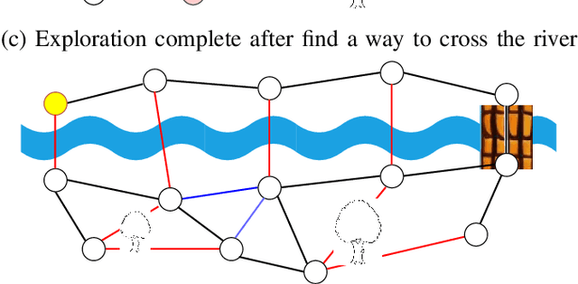
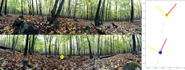
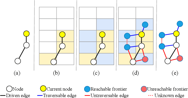
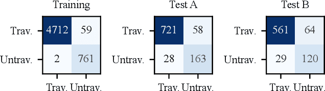
Autonomous robots navigating in off-road terrain like forests open new opportunities for automation. While off-road navigation has been studied, existing work often relies on clearly delineated pathways. We present a method allowing for long-range planning, exploration and low-level control in unknown off-trail forest terrain, using vision and GPS only. We represent outdoor terrain with a topological map, which is a set of panoramic snapshots connected with edges containing traversability information. A novel traversability analysis method is demonstrated, predicting the existence of a safe path towards a target in an image. Navigating between nodes is done using goal-conditioned behavior cloning, leveraging the power of a pretrained vision transformer. An exploration planner is presented, efficiently covering an unknown off-road area with unknown traversability using a frontiers-based approach. The approach is successfully deployed to autonomously explore two 400 meters squared forest sites unseen during training, in difficult conditions for navigation.
FLAGRED -- Fuzzy Logic-based Algorithm Generalizing Risk Estimation for Drones
Feb 07, 2024Accurately estimating risk in real-time is essential for ensuring the safety and efficiency of many applications involving autonomous robot systems. This paper presents a novel, generalizable algorithm for the real-time estimation of risks created by external disturbances on multirotors. Unlike conventional approaches, our method requires no additional sensors, accurate drone models, or large datasets. It employs motor command data in a fuzzy logic system, overcoming barriers to real-world implementation. Inherently adaptable, it utilizes fundamental drone characteristics, making it applicable to diverse drone models. The efficiency of the algorithm has been confirmed through comprehensive real-world testing on various platforms. It proficiently discerned between high and low-risk scenarios resulting from diverse wind disturbances and varying thrust-to-weight ratios. The algorithm surpassed the widely-recognized ArduCopter wind estimation algorithm in performance and demonstrated its capability to promptly detect brief gusts.