 Add to Chrome
 Add to Firefox
 Add to Edge
A Framework for Individual Tree Growth Reconstruction Using Multi-Platform Laser Scanning
Jul 24, 2026
Accurate tree-level forest monitoring using laser scanning data requires reliable tree delineation, consistent tree correspondence across multitemporal point clouds, and accurate estimation of tree attributes and their change. Reconstructing tree growth in boreal forests is challenging due to the scarcity of historical stem-level data, propagation of errors from older sensors into change estimation, and growth rates with a magnitude of measurement uncertainty. This study investigates a framework for estimating individual tree diameter at breast height (DBH) and stem volume growth using 136 point clouds acquired between 2014--2025 with 11 scanners on airborne (ALS), mobile (MLS), and terrestrial laser scanning (TLS) platforms across boreal forest test sites. Trees were delineated from an MLS point cloud using deep learning-based segmentation which was transferred to the remaining point clouds, resulting in reliable multitemporal tree correspondence. Stem curves were derived from MLS/TLS data, with ALS data used for height estimation, enabling DBH and volume estimation and time series. A height growth-based scaling model was used to reconstruct stem attributes across time and estimate growth. Results showed that modeled growth achieved higher agreement with manual growth estimates than differencing independently estimated attributes from point clouds. The modeled-manual 5- and 10-year growth RMSEs were 55--111\% and 26--67\% for DBH, and 31--87\% and 21--67\% for volume, respectively, depending on plot difficulty. The scaling model was temporally robust, with errors remaining stable or stabilizing after 5--6 years, reaching maximum RMSEs of 8--12\% for DBH and 12--23\% for volume after 12 years. Combining MLS/TLS-derived stem measurements with multitemporal ALS-derived heights provided a robust framework for individual tree growth estimation without requiring multiple under-canopy scans.

Unsupervised deep learning for semantic segmentation of multispectral LiDAR forest point clouds
Feb 10, 2025Point clouds captured with laser scanning systems from forest environments can be utilized in a wide variety of applications within forestry and plant ecology, such as the estimation of tree stem attributes, leaf angle distribution, and above-ground biomass. However, effectively utilizing the data in such tasks requires the semantic segmentation of the data into wood and foliage points, also known as leaf-wood separation. The traditional approach to leaf-wood separation has been geometry- and radiometry-based unsupervised algorithms, which tend to perform poorly on data captured with airborne laser scanning (ALS) systems, even with a high point density. While recent machine and deep learning approaches achieve great results even on sparse point clouds, they require manually labeled training data, which is often extremely laborious to produce. Multispectral (MS) information has been demonstrated to have potential for improving the accuracy of leaf-wood separation, but quantitative assessment of its effects has been lacking. This study proposes a fully unsupervised deep learning method, GrowSP-ForMS, which is specifically designed for leaf-wood separation of high-density MS ALS point clouds and based on the GrowSP architecture. GrowSP-ForMS achieved a mean accuracy of 84.3% and a mean intersection over union (mIoU) of 69.6% on our MS test set, outperforming the unsupervised reference methods by a significant margin. When compared to supervised deep learning methods, our model performed similarly to the slightly older PointNet architecture but was outclassed by more recent approaches. Finally, two ablation studies were conducted, which demonstrated that our proposed changes increased the test set mIoU of GrowSP-ForMS by 29.4 percentage points (pp) in comparison to the original GrowSP model and that utilizing MS data improved the mIoU by 5.6 pp from the monospectral case.
Unsupervised semantic segmentation of urban high-density multispectral point clouds
Oct 24, 2024
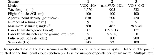


The availability of highly accurate urban airborne laser scanning (ALS) data will increase rapidly in the future, especially as acquisition costs decrease, for example through the use of drones. Current challenges in data processing are related to the limited spectral information and low point density of most ALS datasets. Another challenge will be the growing need for annotated training data, frequently produced by manual processes, to enable semantic interpretation of point clouds. This study proposes to semantically segment new high-density (1200 points per square metre on average) multispectral ALS data with an unsupervised ground-aware deep clustering method GroupSP inspired by the unsupervised GrowSP algorithm. GroupSP divides the scene into superpoints as a preprocessing step. The neural network is trained iteratively by grouping the superpoints and using the grouping assignments as pseudo-labels. The predictions for the unseen data are given by over-segmenting the test set and mapping the predicted classes into ground truth classes manually or with automated majority voting. GroupSP obtained an overall accuracy (oAcc) of 97% and a mean intersection over union (mIoU) of 80%. When compared to other unsupervised semantic segmentation methods, GroupSP outperformed GrowSP and non-deep K-means. However, a supervised random forest classifier outperformed GroupSP. The labelling efforts in GroupSP can be minimal; it was shown, that the GroupSP can semantically segment seven urban classes (building, high vegetation, low vegetation, asphalt, rock, football field, and gravel) with oAcc of 95% and mIoU of 75% using only 0.004% of the available annotated points in the mapping assignment. Finally, the multispectral information was examined; adding each new spectral channel improved the mIoU. Additionally, echo deviation was valuable, especially when distinguishing ground-level classes.