 Add to Chrome
 Add to Firefox
 Add to Edge
SIMPL: Generating Synthetic Overhead Imagery to Address Zero-shot and Few-Shot Detection Problems
Jun 29, 2021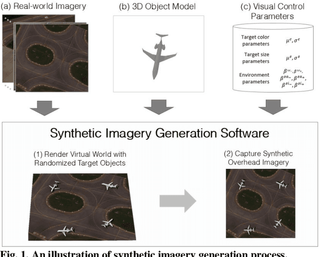
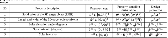
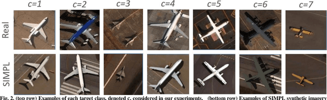
Recently deep neural networks (DNNs) have achieved tremendous success for object detection in overhead (e.g., satellite) imagery. One ongoing challenge however is the acquisition of training data, due to high costs of obtaining satellite imagery and annotating objects in it. In this work we present a simple approach - termed Synthetic object IMPLantation (SIMPL) - to easily and rapidly generate large quantities of synthetic overhead training data for custom target objects. We demonstrate the effectiveness of using SIMPL synthetic imagery for training DNNs in zero-shot scenarios where no real imagery is available; and few-shot learning scenarios, where limited real-world imagery is available. We also conduct experiments to study the sensitivity of SIMPL's effectiveness to some key design parameters, providing users for insights when designing synthetic imagery for custom objects. We release a software implementation of our SIMPL approach so that others can build upon it, or use it for their own custom problems.
Randomized Histogram Matching: A Simple Augmentation for Unsupervised Domain Adaptation in Overhead Imagery
Apr 30, 2021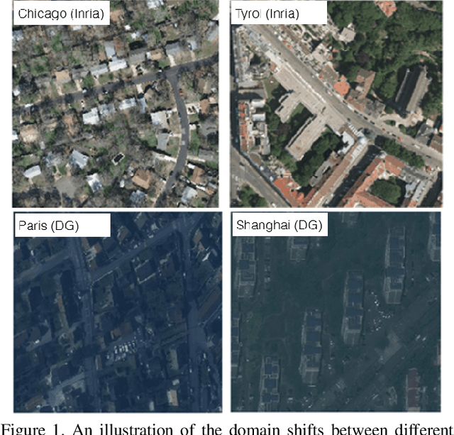
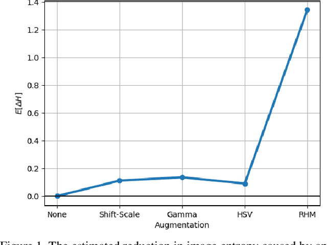
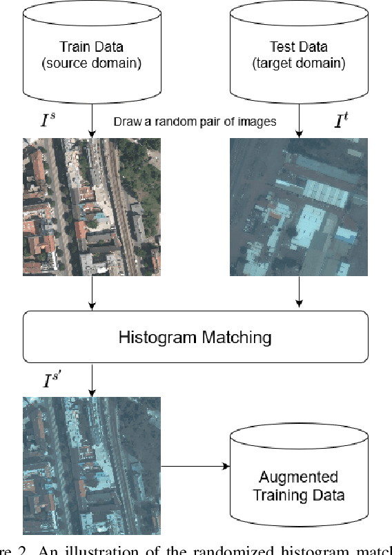
Modern deep neural networks (DNNs) achieve highly accurate results for many recognition tasks on overhead (e.g., satellite) imagery. One challenge however is visual domain shifts (i.e., statistical changes), which can cause the accuracy of DNNs to degrade substantially and unpredictably when tested on new sets of imagery. In this work we model domain shifts caused by variations in imaging hardware, lighting, and other conditions as non-linear pixel-wise transformations; and we show that modern DNNs can become largely invariant to these types of transformations, if provided with appropriate training data augmentation. In general, however, we do not know the transformation between two sets of imagery. To overcome this problem, we propose a simple real-time unsupervised training augmentation technique, termed randomized histogram matching (RHM). We conduct experiments with two large public benchmark datasets for building segmentation and find that RHM consistently yields comparable performance to recent state-of-the-art unsupervised domain adaptation approaches despite being simpler and faster. RHM also offers substantially better performance than other comparably simple approaches that are widely-used in overhead imagery.
The Synthinel-1 dataset: a collection of high resolution synthetic overhead imagery for building segmentation
Jan 15, 2020
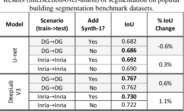
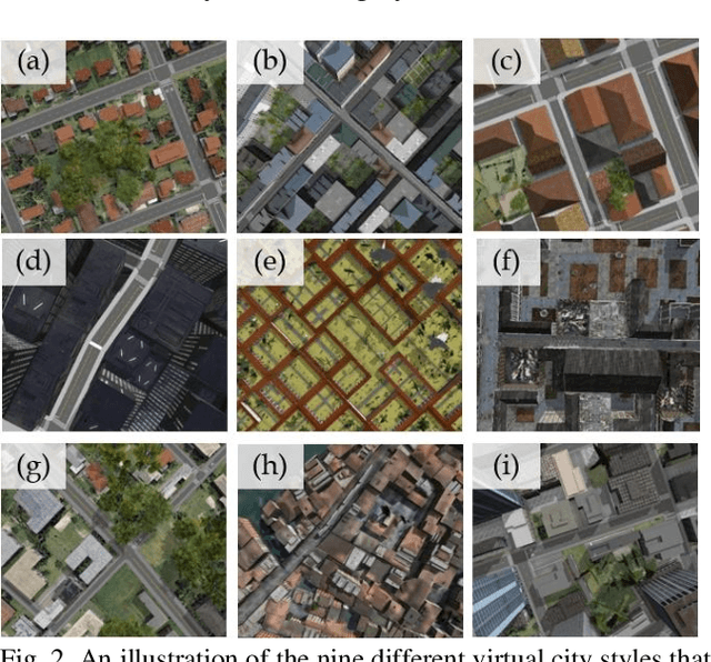
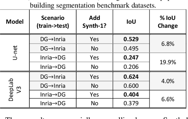
Recently deep learning - namely convolutional neural networks (CNNs) - have yielded impressive performance for the task of building segmentation on large overhead (e.g., satellite) imagery benchmarks. However, these benchmark datasets only capture a small fraction of the variability present in real-world overhead imagery, limiting the ability to properly train, or evaluate, models for real-world application. Unfortunately, developing a dataset that captures even a small fraction of real-world variability is typically infeasible due to the cost of imagery, and manual pixel-wise labeling of the imagery. In this work we develop an approach to rapidly and cheaply generate large and diverse virtual environments from which we can capture synthetic overhead imagery for training segmentation CNNs. Using this approach, generate and publicly-release a collection of synthetic overhead imagery - termed Synthinel-1 with full pixel-wise building labels. We use several benchmark dataset to demonstrate that Synthinel-1 is consistently beneficial when used to augment real-world training imagery, especially when CNNs are tested on novel geographic locations or conditions.
Mapping solar array location, size, and capacity using deep learning and overhead imagery
Feb 28, 2019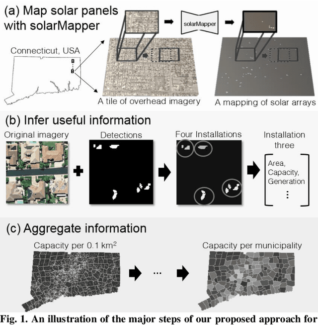
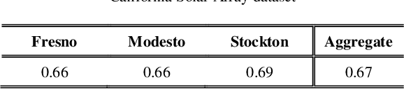

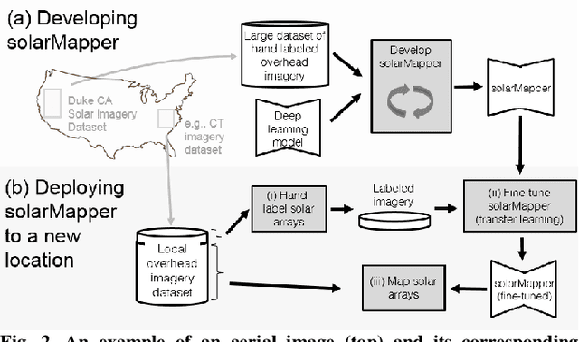
The effective integration of distributed solar photovoltaic (PV) arrays into existing power grids will require access to high quality data; the location, power capacity, and energy generation of individual solar PV installations. Unfortunately, existing methods for obtaining this data are limited in their spatial resolution and completeness. We propose a general framework for accurately and cheaply mapping individual PV arrays, and their capacities, over large geographic areas. At the core of this approach is a deep learning algorithm called SolarMapper - which we make publicly available - that can automatically map PV arrays in high resolution overhead imagery. We estimate the performance of SolarMapper on a large dataset of overhead imagery across three US cities in California. We also describe a procedure for deploying SolarMapper to new geographic regions, so that it can be utilized by others. We demonstrate the effectiveness of the proposed deployment procedure by using it to map solar arrays across the entire US state of Connecticut (CT). Using these results, we demonstrate that we achieve highly accurate estimates of total installed PV capacity within each of CT's 168 municipal regions.
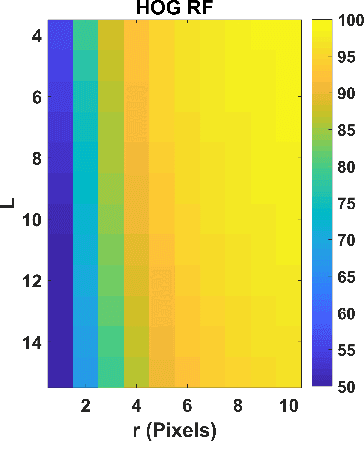
gprHOG and the popularity of Histogram of Oriented Gradients for Buried Threat Detection in Ground-Penetrating Radar
Oct 02, 2018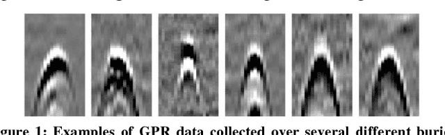
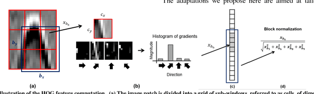
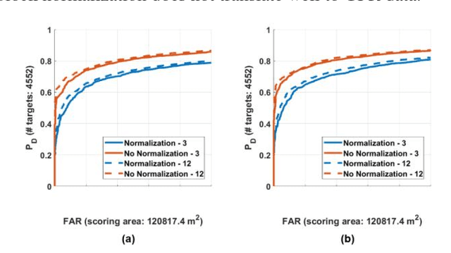
Substantial research has been devoted to the development of algorithms that automate buried threat detection (BTD) with ground penetrating radar (GPR) data, resulting in a large number of proposed algorithms. One popular algorithm GPR-based BTD, originally applied by Torrione et al., 2012, is the Histogram of Oriented Gradients (HOG) feature. In a recent large-scale comparison among five veteran institutions, a modified version of HOG referred to here as "gprHOG", performed poorly compared to other modern algorithms. In this paper, we provide experimental evidence demonstrating that the modifications to HOG that comprise gprHOG result in a substantially better-performing algorithm. The results here, in conjunction with the large-scale algorithm comparison, suggest that HOG is not competitive with modern GPR-based BTD algorithms. Given HOG's popularity, these results raise some questions about many existing studies, and suggest gprHOG (and especially HOG) should be employed with caution in future studies.
A Large-Scale Multi-Institutional Evaluation of Advanced Discrimination Algorithms for Buried Threat Detection in Ground Penetrating Radar
Jun 07, 2018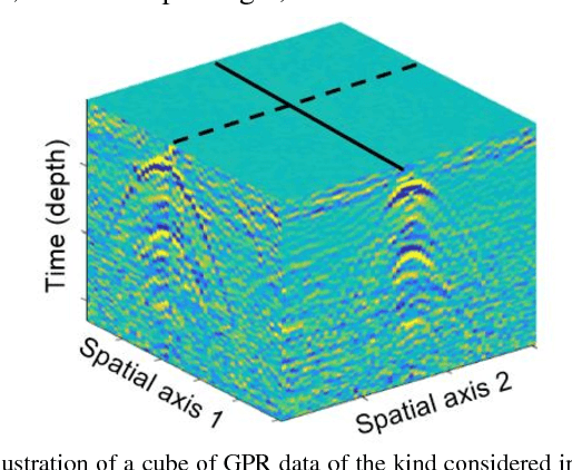
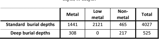
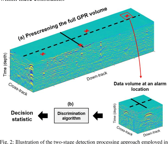
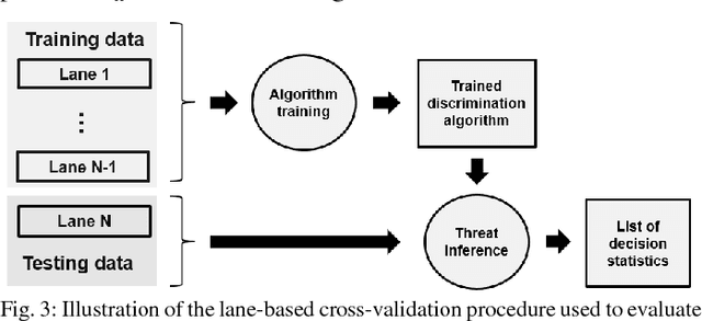
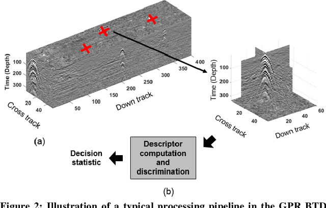
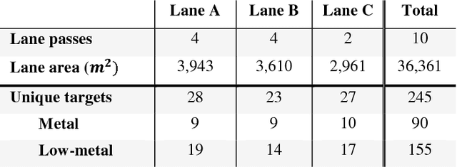
In this paper we consider the development of algorithms for the automatic detection of buried threats using ground penetrating radar (GPR) measurements. GPR is one of the most studied and successful modalities for automatic buried threat detection (BTD), and a large variety of BTD algorithms have been proposed for it. Despite this, large-scale comparisons of GPR-based BTD algorithms are rare in the literature. In this work we report the results of a multi-institutional effort to develop advanced buried threat detection algorithms for a real-world GPR BTD system. The effort involved five institutions with substantial experience with the development of GPR-based BTD algorithms. In this paper we report the technical details of the advanced algorithms submitted by each institution, representing their latest technical advances, and many state-of-the-art GPR-based BTD algorithms. We also report the results of evaluating the algorithms from each institution on the large experimental dataset used for development. The experimental dataset comprised 120,000 m^2 of GPR data using surface area, from 13 different lanes across two US test sites. The data was collected using a vehicle-mounted GPR system, the variants of which have supplied data for numerous publications. Using these results, we identify the most successful and common processing strategies among the submitted algorithms, and make recommendations for GPR-based BTD algorithm design.
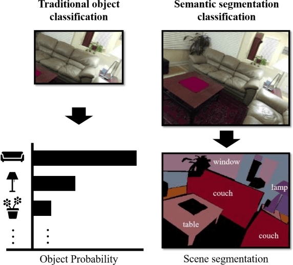
Dense labeling of large remote sensing imagery with convolutional neural networks: a simple and faster alternative to stitching output label maps
May 30, 2018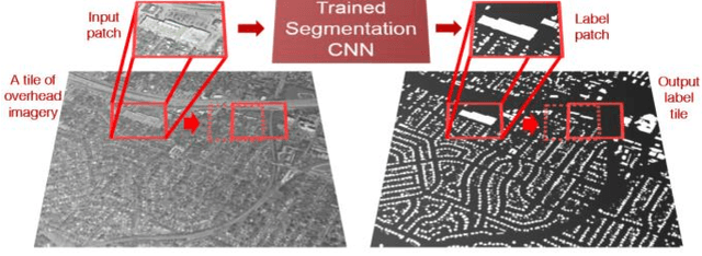
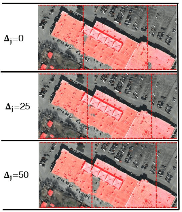
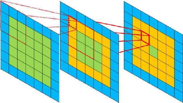
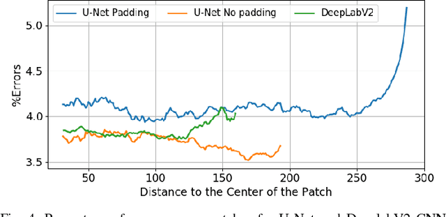
In this work we consider the application of convolutional neural networks (CNNs) for pixel-wise labeling (a.k.a., semantic segmentation) of remote sensing imagery (e.g., aerial color or hyperspectral imagery). Remote sensing imagery is usually stored in the form of very large images, referred to as "tiles", which are too large to be segmented directly using most CNNs and their associated hardware. As a result, during label inference, smaller sub-images, called "patches", are processed individually and then "stitched" (concatenated) back together to create a tile-sized label map. This approach suffers from computational ineffiency and can result in discontinuities at output boundaries. We propose a simple alternative approach in which the input size of the CNN is dramatically increased only during label inference. This does not avoid stitching altogether, but substantially mitigates its limitations. We evaluate the performance of the proposed approach against a vonventional stitching approach using two popular segmentation CNN models and two large-scale remote sensing imagery datasets. The results suggest that the proposed approach substantially reduces label inference time, while also yielding modest overall label accuracy increases. This approach contributed to our wining entry (overall performance) in the INRIA building labeling competition.
Application of a semantic segmentation convolutional neural network for accurate automatic detection and mapping of solar photovoltaic arrays in aerial imagery
Jan 11, 2018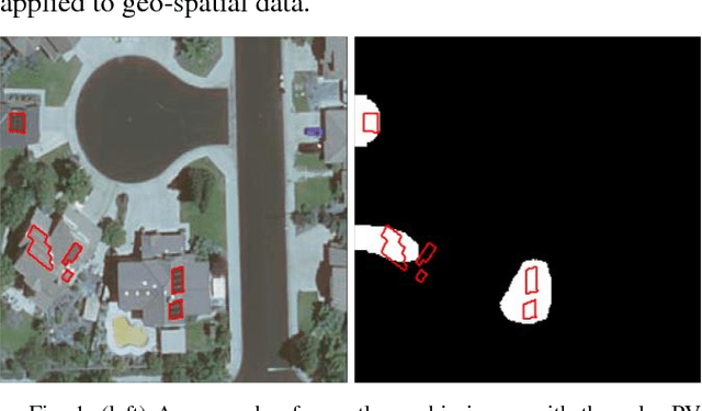
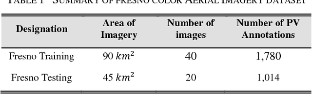
We consider the problem of automatically detecting small-scale solar photovoltaic arrays for behind-the-meter energy resource assessment in high resolution aerial imagery. Such algorithms offer a faster and more cost-effective solution to collecting information on distributed solar photovoltaic (PV) arrays, such as their location, capacity, and generated energy. The surface area of PV arrays, a characteristic which can be estimated from aerial imagery, provides an important proxy for array capacity and energy generation. In this work, we employ a state-of-the-art convolutional neural network architecture, called SegNet (Badrinarayanan et. al., 2015), to semantically segment (or map) PV arrays in aerial imagery. This builds on previous work focused on identifying the locations of PV arrays, as opposed to their specific shapes and sizes. We measure the ability of our SegNet implementation to estimate the surface area of PV arrays on a large, publicly available, dataset that has been employed in several previous studies. The results indicate that the SegNet model yields substantial performance improvements with respect to estimating shape and size as compared to a recently proposed convolutional neural network PV detection algorithm.
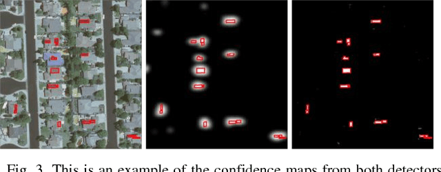
A large comparison of feature-based approaches for buried target classification in forward-looking ground-penetrating radar
Feb 09, 2017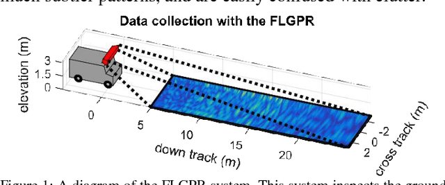
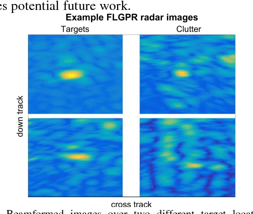
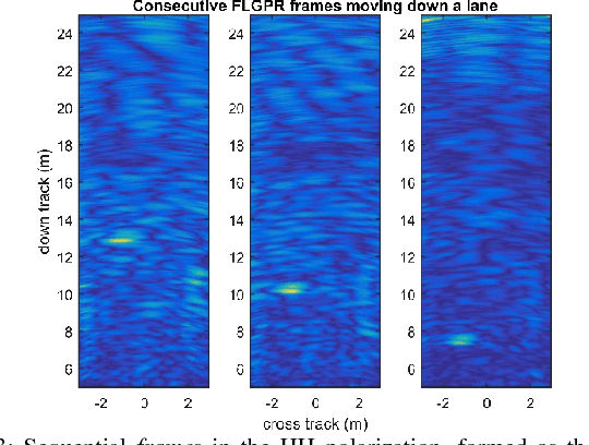
Forward-looking ground-penetrating radar (FLGPR) has recently been investigated as a remote sensing modality for buried target detection (e.g., landmines). In this context, raw FLGPR data is beamformed into images and then computerized algorithms are applied to automatically detect subsurface buried targets. Most existing algorithms are supervised, meaning they are trained to discriminate between labeled target and non-target imagery, usually based on features extracted from the imagery. A large number of features have been proposed for this purpose, however thus far it is unclear which are the most effective. The first goal of this work is to provide a comprehensive comparison of detection performance using existing features on a large collection of FLGPR data. Fusion of the decisions resulting from processing each feature is also considered. The second goal of this work is to investigate two modern feature learning approaches from the object recognition literature: the bag-of-visual-words and the Fisher vector for FLGPR processing. The results indicate that the new feature learning approaches outperform existing methods. Results also show that fusion between existing features and new features yields little additional performance improvements.
On Choosing Training and Testing Data for Supervised Algorithms in Ground Penetrating Radar Data for Buried Threat Detection
Dec 11, 2016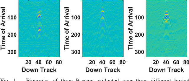
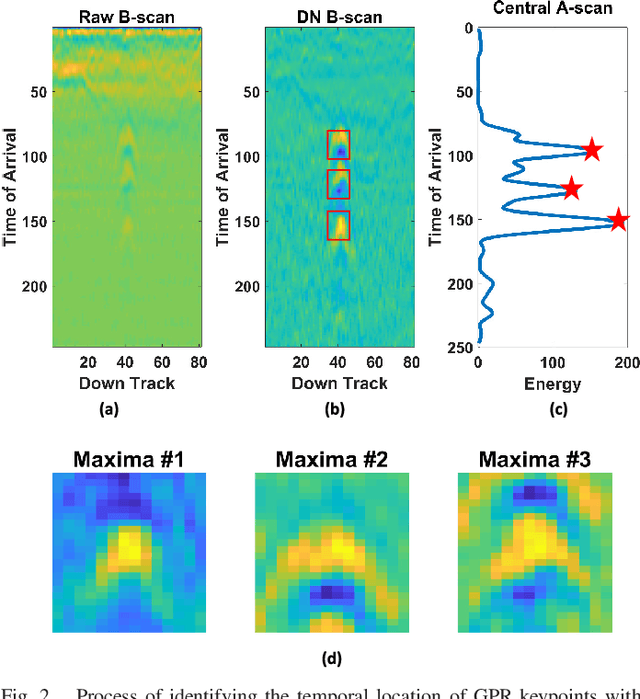
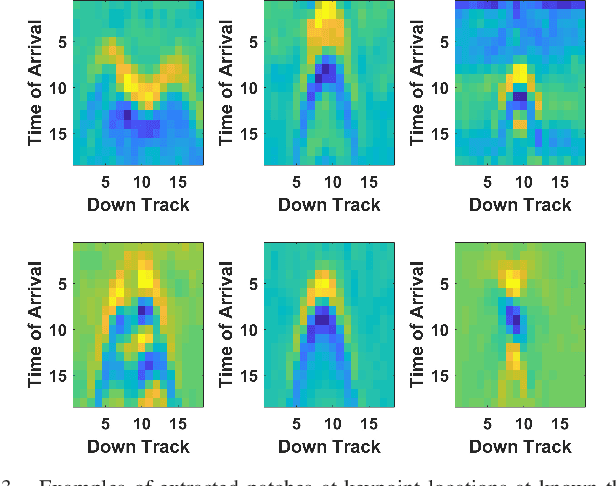
Ground penetrating radar (GPR) is one of the most popular and successful sensing modalities that has been investigated for landmine and subsurface threat detection. Many of the detection algorithms applied to this task are supervised and therefore require labeled examples of target and non-target data for training. Training data most often consists of 2-dimensional images (or patches) of GPR data, from which features are extracted, and provided to the classifier during training and testing. Identifying desirable training and testing locations to extract patches, which we term "keypoints", is well established in the literature. In contrast however, a large variety of strategies have been proposed regarding keypoint utilization (e.g., how many of the identified keypoints should be used at targets, or non-target, locations). Given the variety keypoint utilization strategies that are available, it is very unclear (i) which strategies are best, or (ii) whether the choice of strategy has a large impact on classifier performance. We address these questions by presenting a taxonomy of existing utilization strategies, and then evaluating their effectiveness on a large dataset using many different classifiers and features. We analyze the results and propose a new strategy, called PatchSelect, which outperforms other strategies across all experiments.