 Add to Chrome
 Add to Firefox
 Add to Edge
TRANS: Terrain-aware Reinforcement Learning for Agile Navigation of Quadruped Robots under Social Interactions
Feb 13, 2026This study introduces TRANS: Terrain-aware Reinforcement learning for Agile Navigation under Social interactions, a deep reinforcement learning (DRL) framework for quadrupedal social navigation over unstructured terrains. Conventional quadrupedal navigation typically separates motion planning from locomotion control, neglecting whole-body constraints and terrain awareness. On the other hand, end-to-end methods are more integrated but require high-frequency sensing, which is often noisy and computationally costly. In addition, most existing approaches assume static environments, limiting their use in human-populated settings. To address these limitations, we propose a two-stage training framework with three DRL pipelines. (1) TRANS-Loco employs an asymmetric actor-critic (AC) model for quadrupedal locomotion, enabling traversal of uneven terrains without explicit terrain or contact observations. (2) TRANS-Nav applies a symmetric AC framework for social navigation, directly mapping transformed LiDAR data to ego-agent actions under differential-drive kinematics. (3) A unified pipeline, TRANS, integrates TRANS-Loco and TRANS-Nav, supporting terrain-aware quadrupedal navigation in uneven and socially interactive environments. Comprehensive benchmarks against locomotion and social navigation baselines demonstrate the effectiveness of TRANS. Hardware experiments further confirm its potential for sim-to-real transfer.
ClusterFusion: Leveraging Radar Spatial Features for Radar-Camera 3D Object Detection in Autonomous Vehicles
Sep 07, 2023


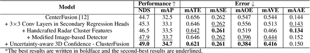
Thanks to the complementary nature of millimeter wave radar and camera, deep learning-based radar-camera 3D object detection methods may reliably produce accurate detections even in low-visibility conditions. This makes them preferable to use in autonomous vehicles' perception systems, especially as the combined cost of both sensors is cheaper than the cost of a lidar. Recent radar-camera methods commonly perform feature-level fusion which often involves projecting the radar points onto the same plane as the image features and fusing the extracted features from both modalities. While performing fusion on the image plane is generally simpler and faster, projecting radar points onto the image plane flattens the depth dimension of the point cloud which might lead to information loss and makes extracting the spatial features of the point cloud harder. We proposed ClusterFusion, an architecture that leverages the local spatial features of the radar point cloud by clustering the point cloud and performing feature extraction directly on the point cloud clusters before projecting the features onto the image plane. ClusterFusion achieved the state-of-the-art performance among all radar-monocular camera methods on the test slice of the nuScenes dataset with 48.7% nuScenes detection score (NDS). We also investigated the performance of different radar feature extraction strategies on point cloud clusters: a handcrafted strategy, a learning-based strategy, and a combination of both, and found that the handcrafted strategy yielded the best performance. The main goal of this work is to explore the use of radar's local spatial and point-wise features by extracting them directly from radar point cloud clusters for a radar-monocular camera 3D object detection method that performs cross-modal feature fusion on the image plane.