 Add to Chrome
 Add to Firefox
 Add to Edge
Mapping of Weed Management Methods in Orchards using Sentinel-2 and PlanetScope Data
Apr 28, 2025


Effective weed management is crucial for improving agricultural productivity, as weeds compete with crops for vital resources like nutrients and water. Accurate maps of weed management methods are essential for policymakers to assess farmer practices, evaluate impacts on vegetation health, biodiversity, and climate, as well as ensure compliance with policies and subsidies. However, monitoring weed management methods is challenging as commonly rely on on-ground field surveys, which are often costly, time-consuming and subject to delays. In order to tackle this problem, we leverage Earth Observation (EO) data and Machine Learning (ML). Specifically, we developed an ML approach for mapping four distinct weed management methods (Mowing, Tillage, Chemical-spraying, and No practice) in orchards using satellite image time series (SITS) data from two different sources: Sentinel-2 (S2) and PlanetScope (PS). The findings demonstrate the potential of ML-driven remote sensing to enhance the efficiency and accuracy of weed management mapping in orchards.
Monitoring digestate application on agricultural crops using Sentinel-2 Satellite imagery
Apr 28, 2025


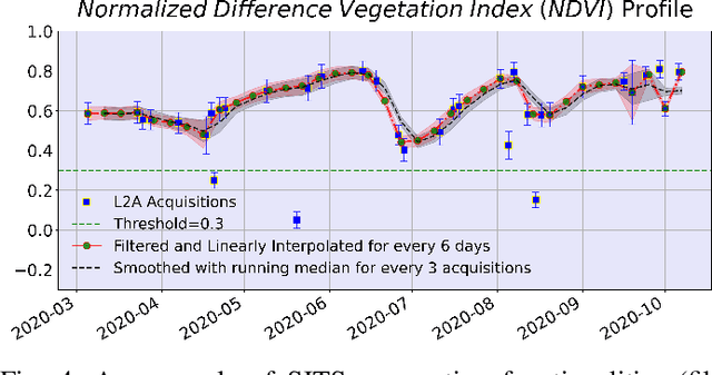
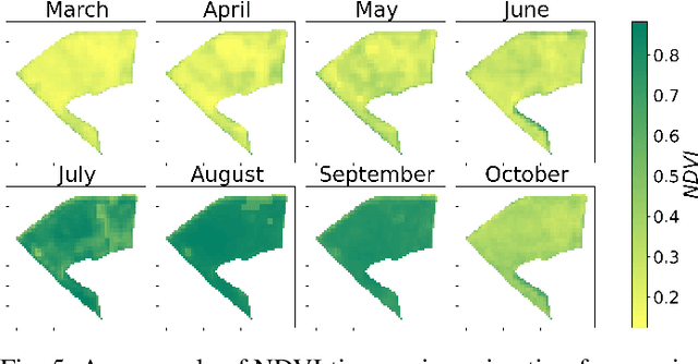
The widespread use of Exogenous Organic Matter in agriculture necessitates monitoring to assess its effects on soil and crop health. This study evaluates optical Sentinel-2 satellite imagery for detecting digestate application, a practice that enhances soil fertility but poses environmental risks like microplastic contamination and nitrogen losses. In the first instance, Sentinel-2 satellite image time series (SITS) analysis of specific indices (EOMI, NDVI, EVI) was used to characterize EOM's spectral behavior after application on the soils of four different crop types in Thessaly, Greece. Furthermore, Machine Learning (ML) models (namely Random Forest, k-NN, Gradient Boosting and a Feed-Forward Neural Network), were used to investigate digestate presence detection, achieving F1-scores up to 0.85. The findings highlight the potential of combining remote sensing and ML for scalable and cost-effective monitoring of EOM applications, supporting precision agriculture and sustainability.
Cloud gap-filling with deep learning for improved grassland monitoring
Mar 14, 2024


Uninterrupted optical image time series are crucial for the timely monitoring of agricultural land changes. However, the continuity of such time series is often disrupted by clouds. In response to this challenge, we propose a deep learning method that integrates cloud-free optical (Sentinel-2) observations and weather-independent (Sentinel-1) Synthetic Aperture Radar (SAR) data, using a combined Convolutional Neural Network (CNN)-Recurrent Neural Network (RNN) architecture to generate continuous Normalized Difference Vegetation Index (NDVI) time series. We emphasize the significance of observation continuity by assessing the impact of the generated time series on the detection of grassland mowing events. We focus on Lithuania, a country characterized by extensive cloud coverage, and compare our approach with alternative interpolation techniques (i.e., linear, Akima, quadratic). Our method surpasses these techniques, with an average MAE of 0.024 and R^2 of 0.92. It not only improves the accuracy of event detection tasks by employing a continuous time series, but also effectively filters out sudden shifts and noise originating from cloudy observations that cloud masks often fail to detect.
A Data Cube of Big Satellite Image Time-Series for Agriculture Monitoring
May 16, 2022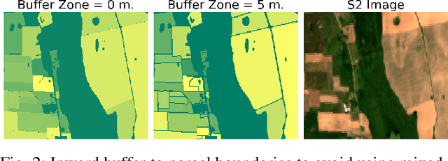

The modernization of the Common Agricultural Policy (CAP) requires the large scale and frequent monitoring of agricultural land. Towards this direction, the free and open satellite data (i.e., Sentinel missions) have been extensively used as the sources for the required high spatial and temporal resolution Earth observations. Nevertheless, monitoring the CAP at large scales constitutes a big data problem and puts a strain on CAP paying agencies that need to adapt fast in terms of infrastructure and know-how. Hence, there is a need for efficient and easy-to-use tools for the acquisition, storage, processing and exploitation of big satellite data. In this work, we present the Agriculture monitoring Data Cube (ADC), which is an automated, modular, end-to-end framework for discovering, pre-processing and indexing optical and Synthetic Aperture Radar (SAR) images into a multidimensional cube. We also offer a set of powerful tools on top of the ADC, including i) the generation of analysis-ready feature spaces of big satellite data to feed downstream machine learning tasks and ii) the support of Satellite Image Time-Series (SITS) analysis via services pertinent to the monitoring of the CAP (e.g., detecting trends and events, monitoring the growth status etc.). The knowledge extracted from the SITS analyses and the machine learning tasks returns to the data cube, building scalable country-specific knowledge bases that can efficiently answer complex and multi-faceted geospatial queries.