 Add to Chrome
 Add to Firefox
 Add to Edge
Computing on the Fly: Navigating a Vision for the Future of Drone Computing
Jul 21, 2026
The report envisions a decade in which drones move goods, medical supplies, and information at a scale comparable to national infrastructure investments like highways and the electric grid. Potential applications include natural disaster detection drones that spot wildfire sources within minutes, medical supply chains that bypass ground congestion to reach rural hospitals, and nationwide fleets that continuously inspect bridges and power lines. Realizing this future, however, requires closing what report authors call a "capability gap," where hardware and aspirations are outpacing the software and systems needed to operate safely at scale. The report identifies twelve technical challenges that must be addressed to realize the transformative potential of drone technology: Scaling to millions of drones; AI intelligence and assurance; Edge-cloud continuum and real-time coordination; AI autonomy and agentic systems; Data, training, and validation infrastructure; Critical infrastructure protection; Building reliable fleets from non-deterministic agents; Trust, security, and distributed authentication; Next-generation drone networks; Human-AI partnership and scalable insight; Standards, certification, and regulation; and Workforce development and education. These twelve challenges and proposed approaches to them form the basis of the report, laying out a multifaceted path forward for the evolution of done technology.

A Hybrid 3D Eddy Detection Technique Based on Sea Surface Height and Velocity Field
May 14, 2023Eddy detection is a critical task for ocean scientists to understand and analyze ocean circulation. In this paper, we introduce a hybrid eddy detection approach that combines sea surface height (SSH) and velocity fields with geometric criteria defining eddy behavior. Our approach searches for SSH minima and maxima, which oceanographers expect to find at the center of eddies. Geometric criteria are used to verify expected velocity field properties, such as net rotation and symmetry, by tracing velocity components along a circular path surrounding each eddy center. Progressive searches outward and into deeper layers yield each eddy's 3D region of influence. Isolation of each eddy structure from the dataset, using it's cylindrical footprint, facilitates visualization of internal eddy structures using horizontal velocity, vertical velocity, temperature and salinity. A quantitative comparison of Okubo-Weiss vorticity (OW) thresholding, the standard winding angle, and this new SSH-velocity hybrid methods of eddy detection as applied to the Red Sea dataset suggests that detection results are highly dependent on the choices of method, thresholds, and criteria. Our new SSH-velocity hybrid detection approach has the advantages of providing eddy structures with verified rotation properties, 3D visualization of the internal structure of physical properties, and rapid efficient estimations of eddy footprints without calculating streamlines. Our approach combines visualization of internal structure and tracking overall movement to support the study of the transport mechanisms key to understanding the interaction of nutrient distribution and ocean circulation. Our method is applied to three different datasets to showcase the generality of its application.
A Bounded Measure for Estimating the Benefit of Visualization
Feb 12, 2020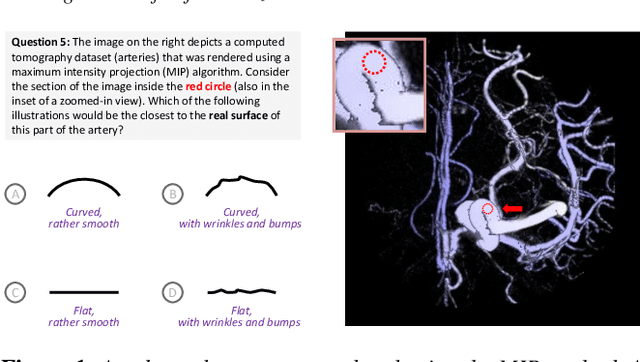
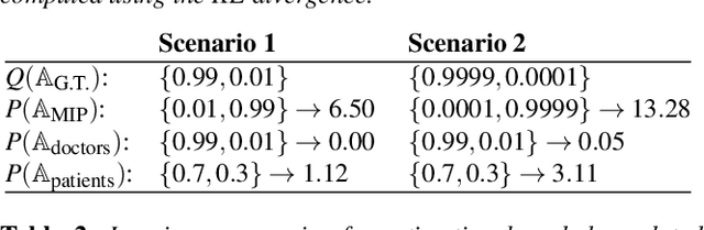
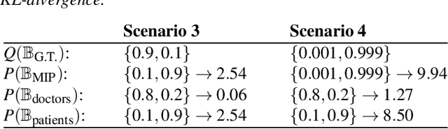
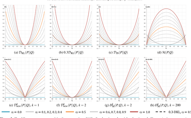
Information theory can be used to analyze the cost-benefit of visualization processes. However, the current measure of benefit contains an unbounded term that is neither easy to estimate nor intuitive to interpret. In this work, we propose to revise the existing cost-benefit measure by replacing the unbounded term with a bounded one. We examine a number of bounded measures that include the Jenson-Shannon divergence and a new divergence measure formulated as part of this work. We use visual analysis to support the multi-criteria comparison, enabling the selection of the most logical and intuitive option. We applied the revised cost-benefit measure to two case studies, demonstrating its uses in practical scenarios, while the collected real world data further informs the selection of a bounded measure.