 Add to Chrome
 Add to Firefox
 Add to Edge
Intelligent Travel Activity Monitoring: Generalized Distributed Acoustic Sensing Approaches
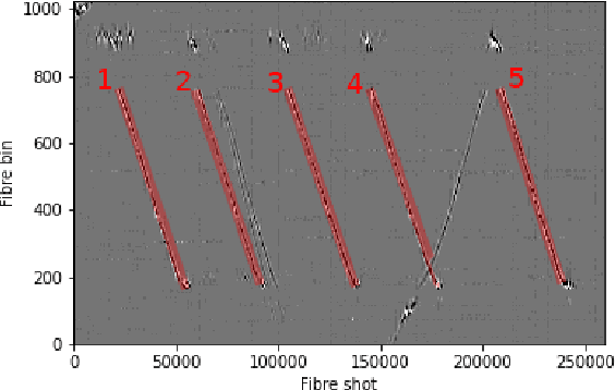
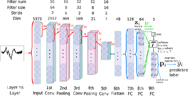
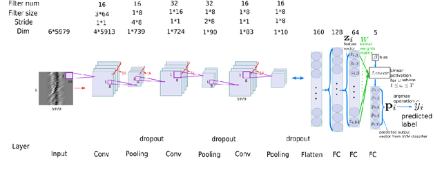
Jun 11, 2025Obtaining data on active travel activities such as walking, jogging, and cycling is important for refining sustainable transportation systems (STS). Effectively monitoring these activities not only requires sensing solutions to have a joint feature of being accurate, economical, and privacy-preserving, but also enough generalizability to adapt to different climate environments and deployment conditions. In order to provide a generalized sensing solution, a deep learning (DL)-enhanced distributed acoustic sensing (DAS) system for monitoring active travel activities is proposed. By leveraging the ambient vibrations captured by DAS, this scheme infers motion patterns without relying on image-based or wearable devices, thereby addressing privacy concerns. We conduct real-world experiments in two geographically distinct locations and collect comprehensive datasets to evaluate the performance of the proposed system. To address the generalization challenges posed by heterogeneous deployment environments, we propose two solutions according to network availability: 1) an Internet-of-Things (IoT) scheme based on federated learning (FL) is proposed, and it enables geographically different DAS nodes to be trained collaboratively to improve generalizability; 2) an off-line initialization approach enabled by meta-learning is proposed to develop high-generality initialization for DL models and to enable rapid model fine-tuning with limited data samples, facilitating generalization at newly established or isolated DAS nodes. Experimental results of the walking and cycling classification problem demonstrate the performance and generalizability of the proposed DL-enhanced DAS system, paving the way for practical, large-scale DAS monitoring of active travel.
A low complexity contextual stacked ensemble-learning approach for pedestrian intent prediction
Oct 16, 2024


Walking as a form of active travel is essential in promoting sustainable transport. It is thus crucial to accurately predict pedestrian crossing intention and avoid collisions, especially with the advent of autonomous and advanced driver-assisted vehicles. Current research leverages computer vision and machine learning advances to predict near-misses; however, this often requires high computation power to yield reliable results. In contrast, this work proposes a low-complexity ensemble-learning approach that employs contextual data for predicting the pedestrian's intent for crossing. The pedestrian is first detected, and their image is then compressed using skeleton-ization, and contextual information is added into a stacked ensemble-learning approach. Our experiments on different datasets achieve similar pedestrian intent prediction performance as the state-of-the-art approaches with 99.7% reduction in computational complexity. Our source code and trained models will be released upon paper acceptance
A Distributed Acoustic Sensor System for Intelligent Transportation using Deep Learning
Sep 13, 2022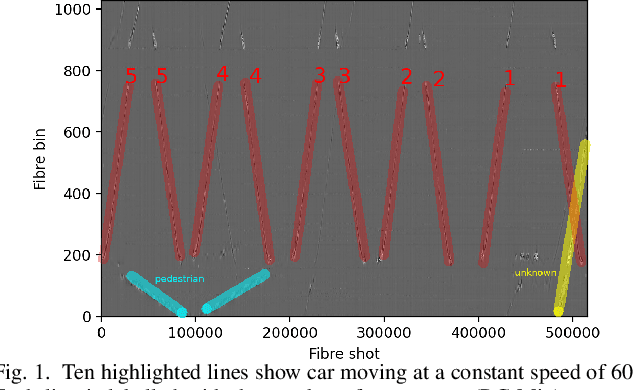
Intelligent transport systems (ITS) are pivotal in the development of sustainable and green urban living. ITS is data-driven and enabled by the profusion of sensors ranging from pneumatic tubes to smart cameras. This work explores a novel data source based on optical fibre-based distributed acoustic sensors (DAS) for traffic analysis. Detecting the type of vehicle and estimating the occupancy of vehicles are prime concerns in ITS. The first is motivated by the need for tracking, controlling, and forecasting traffic flow. The second targets the regulation of high occupancy vehicle lanes in an attempt to reduce emissions and congestion. These tasks are often conducted by individuals inspecting vehicles or through the use of emerging computer vision technologies. The former is not scale-able nor efficient whereas the latter is intrusive to passengers' privacy. To this end, we propose a deep learning technique to analyse DAS signals to address this challenge through continuous sensing and without exposing personal information. We propose a deep learning method for processing DAS signals and achieve 92% vehicle classification accuracy and 92-97% in occupancy detection based on DAS data collected under controlled conditions.
Deep Learning based Automated Forest Health Diagnosis from Aerial Images
Oct 16, 2020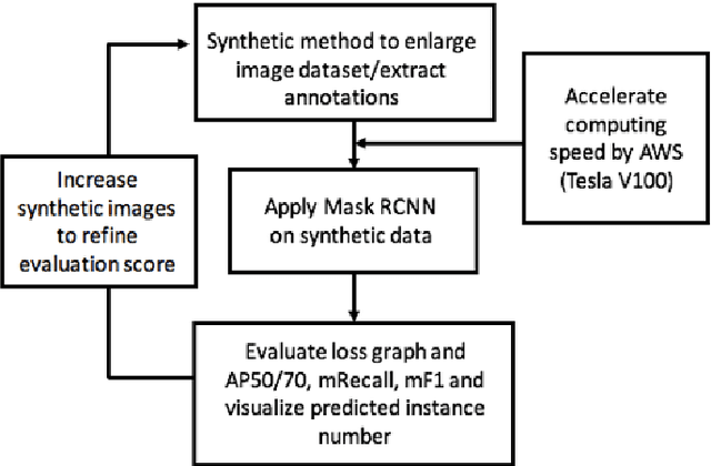
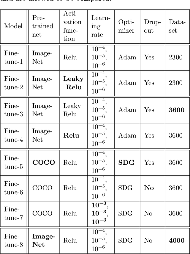
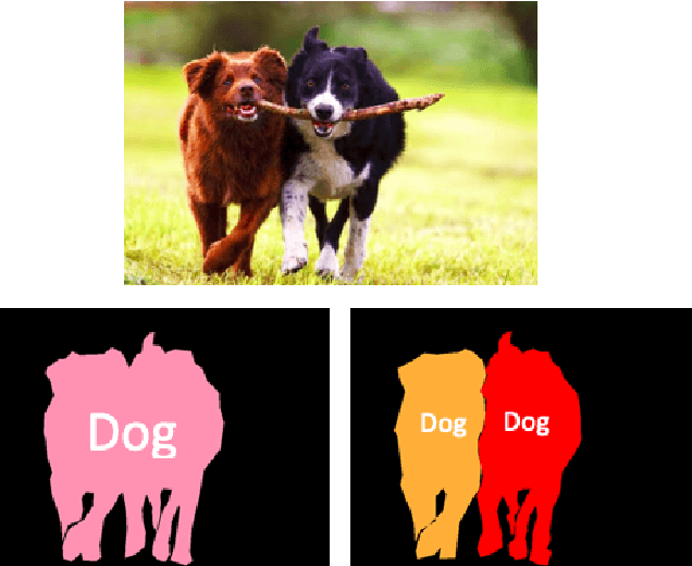
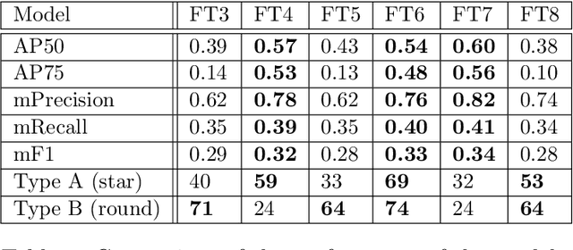
Global climate change has had a drastic impact on our environment. Previous study showed that pest disaster occured from global climate change may cause a tremendous number of trees died and they inevitably became a factor of forest fire. An important portent of the forest fire is the condition of forests. Aerial image-based forest analysis can give an early detection of dead trees and living trees. In this paper, we applied a synthetic method to enlarge imagery dataset and present a new framework for automated dead tree detection from aerial images using a re-trained Mask RCNN (Mask Region-based Convolutional Neural Network) approach, with a transfer learning scheme. We apply our framework to our aerial imagery datasets,and compare eight fine-tuned models. The mean average precision score (mAP) for the best of these models reaches 54%. Following the automated detection, we are able to automatically produce and calculate number of dead tree masks to label the dead trees in an image, as an indicator of forest health that could be linked to the causal analysis of environmental changes and the predictive likelihood of forest fire.
* 16 pages