 Add to Chrome
 Add to Firefox
 Add to Edge
Thick Cloud Removal of Remote Sensing Images Using Temporal Smoothness and Sparsity-Regularized Tensor Optimization
Sep 01, 2020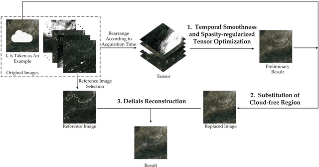
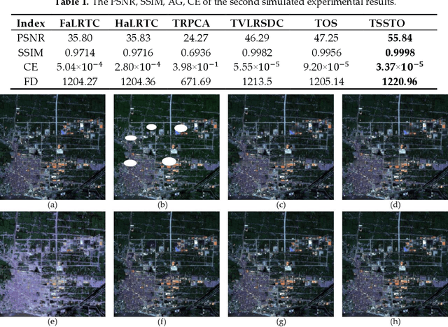
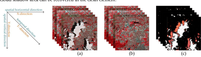
In remote sensing images, the presence of thick cloud accompanying cloud shadow is a high probability event, which can affect the quality of subsequent processing and limit the scenarios of application. Hence, removing the thick cloud and cloud shadow as well as recovering the cloud-contaminated pixels is indispensable to make good use of remote sensing images. In this paper, a novel thick cloud removal method for remote sensing images based on temporal smoothness and sparsity-regularized tensor optimization (TSSTO) is proposed. The basic idea of TSSTO is that the thick cloud and cloud shadow are not only sparse but also smooth along the horizontal and vertical direction in images while the clean images are smooth along the temporal direction between images. Therefore, the sparsity norm is used to boost the sparsity of the cloud and cloud shadow, and unidirectional total variation (UTV) regularizers are applied to ensure the unidirectional smoothness. This paper utilizes alternation direction method of multipliers to solve the presented model and generate the cloud and cloud shadow element as well as the clean element. The cloud and cloud shadow element is purified to get the cloud area and cloud shadow area. Then, the clean area of the original cloud-contaminated images is replaced to the corresponding area of the clean element. Finally, the reference image is selected to reconstruct details of the cloud area and cloud shadow area using the information cloning method. A series of experiments are conducted both on simulated and real cloud-contaminated images from different sensors and with different resolutions, and the results demonstrate the potential of the proposed TSSTO method for removing cloud and cloud shadow from both qualitative and quantitative viewpoints.
Linear Attention Mechanism: An Efficient Attention for Semantic Segmentation
Aug 20, 2020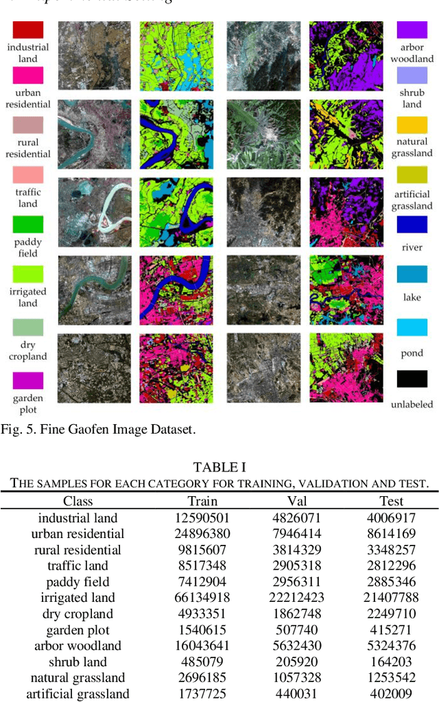
In this paper, to remedy this deficiency, we propose a Linear Attention Mechanism which is approximate to dot-product attention with much less memory and computational costs. The efficient design makes the incorporation between attention mechanisms and neural networks more flexible and versatile. Experiments conducted on semantic segmentation demonstrated the effectiveness of linear attention mechanism. Code is available at https://github.com/lironui/Linear-Attention-Mechanism.
Land Cover Classification from Remote Sensing Images Based on Multi-Scale Fully Convolutional Network
Aug 01, 2020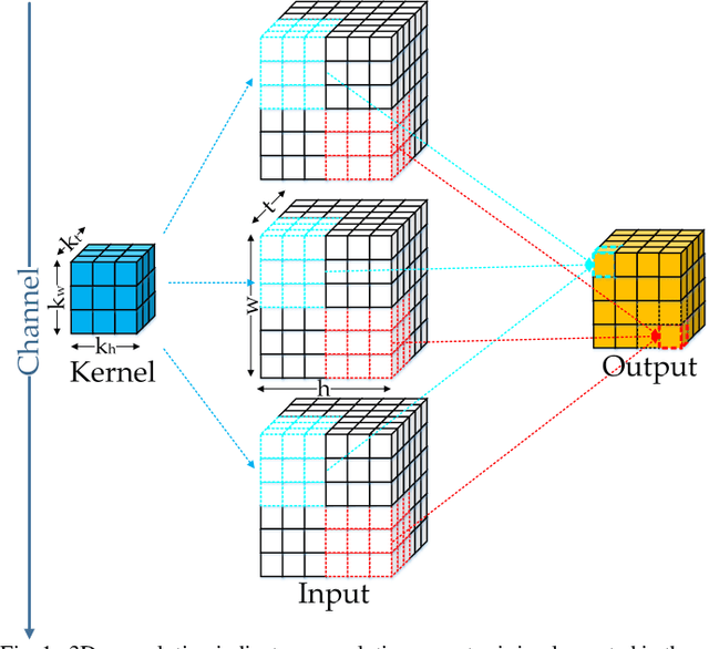
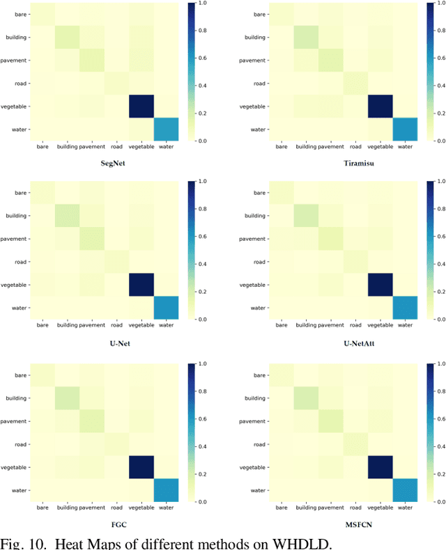
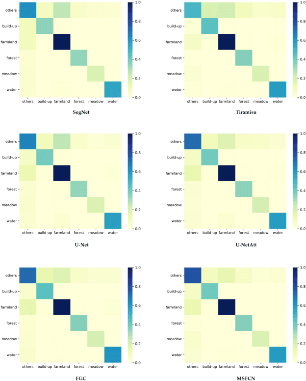
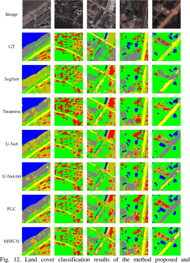
In this paper, a Multi-Scale Fully Convolutional Network (MSFCN) with multi-scale convolutional kernel is proposed to exploit discriminative representations from two-dimensional (2D) satellite images.
MACU-Net Semantic Segmentation from High-Resolution Remote Sensing Images
Jul 26, 2020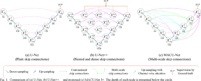
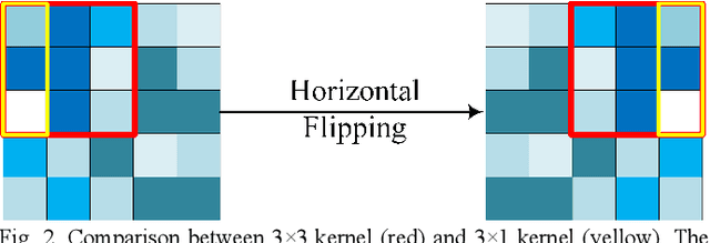
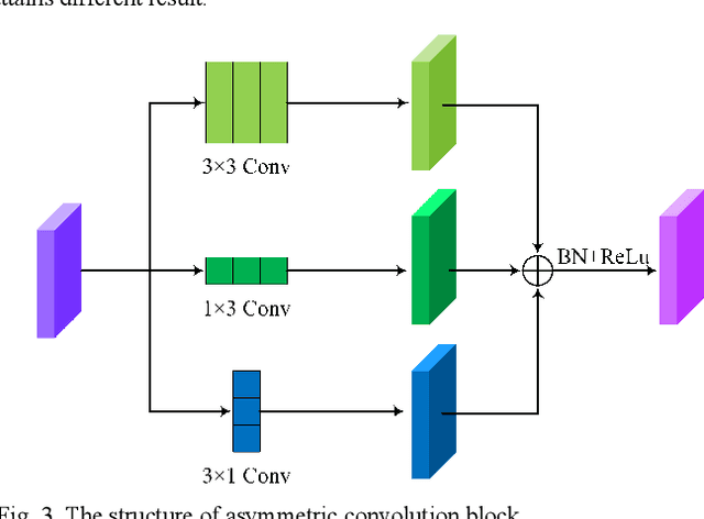
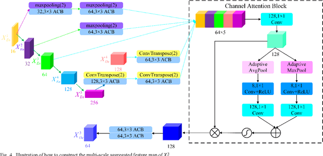
Semantic segmentation of remote sensing images plays an important role in land resource management, yield estimation, and economic assessment. U-Net is a sophisticated encoder-decoder architecture which has been frequently used in medical image segmentation and has attained prominent performance. And asymmetric convolution block can enhance the square convolution kernels using asymmetric convolutions. In this paper, based on U-Net and asymmetric convolution block, we incorporate multi-scale features generated by different layers of U-Net and design a multi-scale skip connected architecture, MACU-Net, for semantic segmentation using high-resolution remote sensing images. Our design has the following advantages: (1) The multi-scale skip connections combine and realign semantic features contained both in low-level and high-level feature maps with different scales; (2) the asymmetric convolution block strengthens the representational capacity of a standard convolution layer. Experiments conducted on two remote sensing image datasets captured by separate satellites demonstrate that the performance of our MACU-Net transcends the U-Net, SegNet, DeepLab V3+, and other baseline algorithms.
LiteDenseNet: A Lightweight Network for Hyperspectral Image Classification
Apr 26, 2020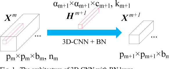
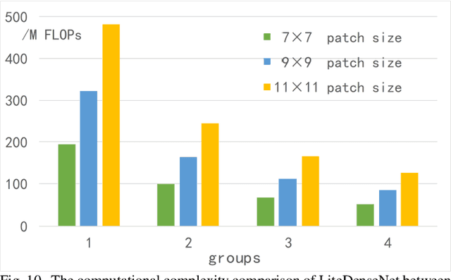
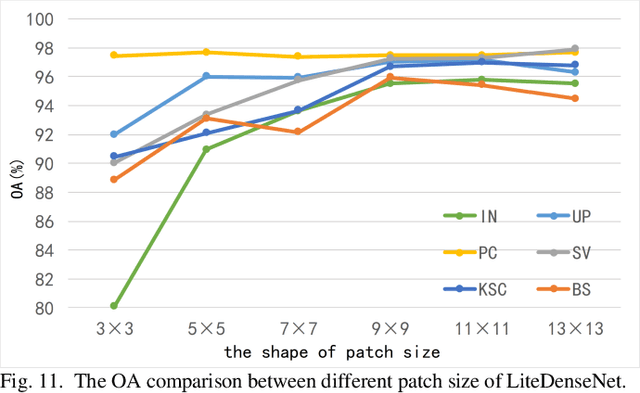
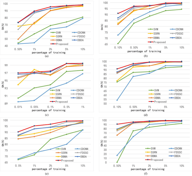
Hyperspectral Image (HSI) classification based on deep learning has been an attractive area in recent years. However, as a kind of data-driven algorithm, deep learning method usually requires numerous computational resources and high-quality labelled dataset, while the cost of high-performance computing and data annotation is expensive. In this paper, to reduce dependence on massive calculation and labelled samples, we propose a lightweight network architecture (LiteDenseNet) based on DenseNet for Hyperspectral Image Classification. Inspired by GoogLeNet and PeleeNet, we design a 3D two-way dense layer to capture the local and global features of the input. As convolution is a computationally intensive operation, we introduce group convolution to decrease calculation cost and parameter size further. Thus, the number of parameters and the consumptions of calculation are observably less than contrapositive deep learning methods, which means LiteDenseNet owns simpler architecture and higher efficiency. A series of quantitative experiences on 6 widely used hyperspectral datasets show that the proposed LiteDenseNet obtains the state-of-the-art performance, even though when the absence of labelled samples is severe.