 Add to Chrome
 Add to Firefox
 Add to Edge
Clustering Guided Domain-Specific Pretrained Foundation Model for Very High-Resolution Arctic Remote Sensing
Jun 03, 2026
This study introduces a novel Arctic-focused remote sensing foundation model (RSFM) by combining diversity-aware regional-scale image curation with masked autoencoder (MAE) self-supervised pretraining of a Vision Transformer (ViT) encoder for very-high-spatial-resolution (VHSR) satellite image analysis. Spectral and acquisition-metadata descriptors were used in a scalable affinity-propagation clustering workflow to select approximately 3 million chips from 267 TB of Vantor VHSR imagery This curation strategy was designed to reduce oversampling of visually repetitive or low-information areas while preserving broad scene diversity across the study domain. We pretrained a ViT-Large encoder on the curated corpus using a domain-adapted MAE reconstruction objective, producing Arctic-specific transformer weights for downstream feature mapping. The pretrained encoder was integrated into an existing location-aware detection and segmentation framework and evaluated across four hand-labeled Arctic datasets. Compared to ImageNet-initialized ViT-Large baseline, Arctic MAE pretraining produced consistent improvements in foreground mean F1 scores of 0.87, 0.72, 0.93, and 0.87, for infrastructure, IWP, RTS, and TCNs, with approximately 5-8 percentage increase. The proposed model also outperformed Prithvi-EO-2.0 in all downstream comparisons, with the smallest gain corresponding to at least a 15 percentage improvement mean F1, suggesting that domain-specific self-supervised pretraining on curated Arctic VHSR imagery provides more transferable representations for fine-scale Arctic mapping than a general-purpose Earth observation foundation model. These results demonstrate that optimizing the pretraining data distribution at regional scale, while keeping the architecture and MAE objective fixed, can produce a reusable Arctic-domain encoder for multiple VHSR remote sensing applications.

Segment Anything Model Can Not Segment Anything: Assessing AI Foundation Model's Generalizability in Permafrost Mapping
Jan 16, 2024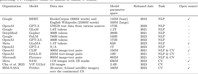
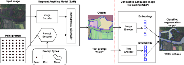
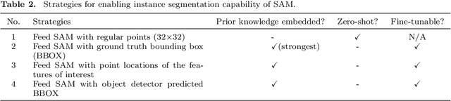
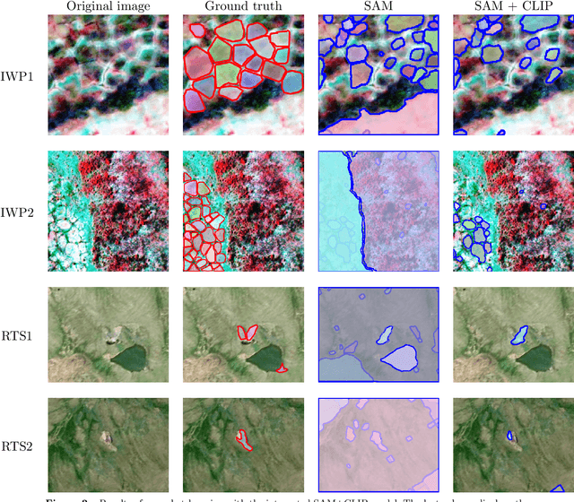
This paper assesses trending AI foundation models, especially emerging computer vision foundation models and their performance in natural landscape feature segmentation. While the term foundation model has quickly garnered interest from the geospatial domain, its definition remains vague. Hence, this paper will first introduce AI foundation models and their defining characteristics. Built upon the tremendous success achieved by Large Language Models (LLMs) as the foundation models for language tasks, this paper discusses the challenges of building foundation models for geospatial artificial intelligence (GeoAI) vision tasks. To evaluate the performance of large AI vision models, especially Meta's Segment Anything Model (SAM), we implemented different instance segmentation pipelines that minimize the changes to SAM to leverage its power as a foundation model. A series of prompt strategies was developed to test SAM's performance regarding its theoretical upper bound of predictive accuracy, zero-shot performance, and domain adaptability through fine-tuning. The analysis used two permafrost feature datasets, ice-wedge polygons and retrogressive thaw slumps because (1) these landform features are more challenging to segment than manmade features due to their complicated formation mechanisms, diverse forms, and vague boundaries; (2) their presence and changes are important indicators for Arctic warming and climate change. The results show that although promising, SAM still has room for improvement to support AI-augmented terrain mapping. The spatial and domain generalizability of this finding is further validated using a more general dataset EuroCrop for agricultural field mapping. Finally, we discuss future research directions that strengthen SAM's applicability in challenging geospatial domains.
Real-time GeoAI for High-resolution Mapping and Segmentation of Arctic Permafrost Features
Jun 08, 2023This paper introduces a real-time GeoAI workflow for large-scale image analysis and the segmentation of Arctic permafrost features at a fine-granularity. Very high-resolution (0.5m) commercial imagery is used in this analysis. To achieve real-time prediction, our workflow employs a lightweight, deep learning-based instance segmentation model, SparseInst, which introduces and uses Instance Activation Maps to accurately locate the position of objects within the image scene. Experimental results show that the model can achieve better accuracy of prediction at a much faster inference speed than the popular Mask-RCNN model.