 Add to Chrome
 Add to Firefox
 Add to Edge
HASTE: A Platform for Rapid Post-Disaster Building Damage Assessment
Jul 13, 2026
When a large disaster strikes, responders need a map of which buildings are damaged within hours. The models that do well on public benchmarks assume matched before-and-after imagery and a training set drawn from similar past events, and neither is usually available for a new disaster in its first day. We present HASTE (High-speed Assessment and Satellite Tracking for Emergencies), a no-code web platform that lets analysts who are not machine learning engineers produce per-building damage maps from post-disaster satellite imagery. HASTE implements two methods that share one interface. The first requires the user to label polygons over the post-disaster scene, trains a small semantic segmentation model on that single scene, runs it over the whole image, and joins the per-pixel output to existing building footprints. The second embeds every footprint with a pretrained vision model, requires the user to label a handful of buildings, and fits a logistic regression in the browser that scores the rest of the scene in seconds. We describe the platform, both methods, and the engineering that supports them. We also report preliminary experiments on xBD showing that foundation-model embeddings pooled over footprints separate damaged from intact buildings using post-disaster imagery alone, matching a fully supervised ResNet-50 baseline with a twentieth of its labels. HASTE and its predecessors have supported more than thirty real-world disaster responses since 2023, spanning earthquakes, hurricanes, cyclones, floods, wildfires, and tornadoes, delivering results to humanitarian partners within hours to days of imagery becoming available. We close with the directions we think are most promising, including vision-language assessment, active learning, and damage models for roads and other infrastructure. HASTE is open source at https://github.com/microsoft/haste.

Open Datasheets: Machine-readable Documentation for Open Datasets and Responsible AI Assessments
Dec 11, 2023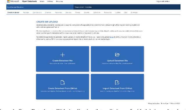
This paper introduces a no-code, machine-readable documentation framework for open datasets, with a focus on Responsible AI (RAI) considerations. The framework aims to improve the accessibility, comprehensibility, and usability of open datasets, facilitating easier discovery and use, better understanding of content and context, and evaluation of dataset quality and accuracy. The proposed framework is designed to streamline the evaluation of datasets, helping researchers, data scientists, and other open data users quickly identify datasets that meet their needs and/or organizational policies or regulations. The paper also discusses the implementation of the framework and provides recommendations to maximize its potential. The framework is expected to enhance the quality and reliability of data used in research and decision-making, fostering the development of more responsible and trustworthy AI systems.
Open Data on GitHub: Unlocking the Potential of AI
Jun 09, 2023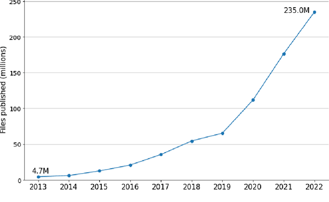
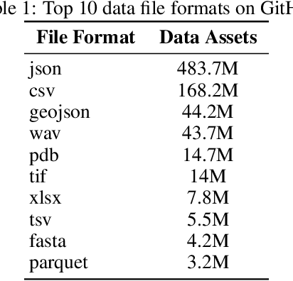
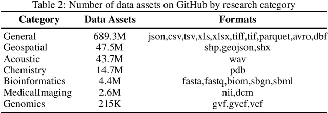
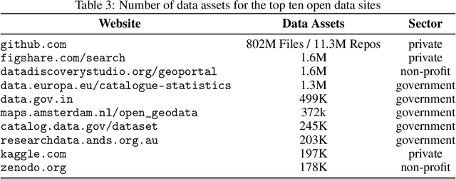
GitHub is the world's largest platform for collaborative software development, with over 100 million users. GitHub is also used extensively for open data collaboration, hosting more than 800 million open data files, totaling 142 terabytes of data. This study highlights the potential of open data on GitHub and demonstrates how it can accelerate AI research. We analyze the existing landscape of open data on GitHub and the patterns of how users share datasets. Our findings show that GitHub is one of the largest hosts of open data in the world and has experienced an accelerated growth of open data assets over the past four years. By examining the open data landscape on GitHub, we aim to empower users and organizations to leverage existing open datasets and improve their discoverability -- ultimately contributing to the ongoing AI revolution to help address complex societal issues. We release the three datasets that we have collected to support this analysis as open datasets at https://github.com/github/open-data-on-github.