 Add to Chrome
 Add to Firefox
 Add to Edge
Flood severity mapping from Volunteered Geographic Information by interpreting water level from images containing people: a case study of Hurricane Harvey
Paper and Code
Jun 21, 2020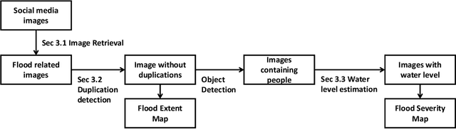
With increasing urbanization, in recent years there has been a growing interest and need in monitoring and analyzing urban flood events. Social media, as a new data source, can provide real-time information for flood monitoring. The social media posts with locations are often referred to as Volunteered Geographic Information (VGI), which can reveal the spatial pattern of such events. Since more images are shared on social media than ever before, recent research focused on the extraction of flood-related posts by analyzing images in addition to texts. Apart from merely classifying posts as flood relevant or not, more detailed information, e.g. the flood severity, can also be extracted based on image interpretation. However, it has been less tackled and has not yet been applied for flood severity mapping. In this paper, we propose a novel three-step pipeline method to extract and map flood severity information. First, flood relevant images are retrieved with the help of pre-trained convolutional neural networks as feature extractors. Second, the images containing people are further classified into four severity levels by observing the relationship between body parts and their partial inundation, i.e. images are classified according to the water level with respect to different body parts, namely ankle, knee, hip, and chest. Lastly, locations of the Tweets are used for generating a map of estimated flood extent and severity. This pipeline was applied to an image dataset collected during Hurricane Harvey in 2017, as a proof of concept. The results show that VGI can be used as a supplement to remote sensing observations for flood extent mapping and is beneficial, especially for urban areas, where the infrastructure is often occluding water. Based on the extracted water level information, an integrated overview of flood severity can be provided for the early stages of emergency response.