 Add to Chrome
 Add to Firefox
 Add to Edge
Embeddings based Anomaly Detection for Cleaning Global Crop Type Reference Datasets
Jul 27, 2026
High quality reference data remain a critical bottleneck for crop-type mapping at any spatial and temporal scale. Operational systems such as WorldCereal aggregate labels from heterogeneous sources such as parcel registers, national databases, field surveys, and map-derived products, each with their own biases, coverage gaps and unknown label noise. Simple global rules are inadequate, since crop phenology and observation conditions vary strongly across regions and seasons. In this study, we focus on a single, operationally relevant question: whether embeddings produced through geospatial foundation models are a viable basis for cleaning the reference data. We propose a practical, locality-aware, embedding-based anomaly (EBA) detection framework that operates on the embeddings of a pretrained Earth-observation encoder. We score each labelled sample against other samples of the same crop in the same area using a pretrained embedding, flag the ones that stand out, and test whether removing or down-weighting them before training yields a better model. We establish that the flagged points are genuinely mislabelled or misplaced in two independent ways: against synthetic ground truth, the detector concentrates injected label errors 2.5-5x above chance in its flagged set (detection AUROC up to 0.84); and on real data, a model-independent test shows that removing or confidence-weighting the flagged held-out points raises measured accuracy in trained models, for both crop type and land cover. Acting on the flags then improves the WorldCereal crop-type model across five macro-regions, evaluated on a fixed held-out split under three views. We find conservative cleaning helps while over-cleaning hurts. The EBA detector approach is designed to be reproducible and extensible, and can serve as a template for cleaning large, noisy Earth observation reference datasets beyond crop mapping.

Delineate Anything v2: A Global Foundation Model for Field Delineation
Jul 21, 2026Accurate agricultural field boundary delineation at large scale is a foundational task for food security, supply chain transparency, and carbon accounting. While vision foundation models like SAM show remarkable zero-shot capabilities, they frequently fail in geospatial domains due to topological complexity, cropland texturing patterns, and a lack of physical scale awareness. In this work, we introduce Delineate Anything v2, a globally scalable foundation model designed specifically for wide-area field boundary mapping. We construct FBIS-73M, a 73-million-instance multi-resolution dataset spanning 61 countries. To address the pervasive issue of multi-field administrative parcel merging, we introduce a resolution-specific data curation pipeline that leverages topological image-space adaptation to homogenize merged parcels and strengthen weak physical boundaries. Furthermore, we establish a novel, manually curated evaluation benchmark covering 100 countries to assess independent zero-shot generalization. Our results show that Delineate Anything v2 surpasses the current state-of-the-art, including the Delineate Anything framework, by 0.284 mAP@0.5 (+103.3% relative gain), while maintaining execution speeds suitable for rapid national- and global-scale deployment, as demonstrated by nationwide mapping of Ukraine (603,000 km^2) in 5.4 hours on a consumer-grade workstation. Code, pre-trained weights, the FBIS-73M dataset, and ready-to-use national-scale vector boundary products are publicly available at https://github.com/Lavreniuk/Delineate-Anything.
Delineate Anything Flow: Fast, Country-Level Field Boundary Detection from Any Source
Nov 17, 2025Accurate delineation of agricultural field boundaries from satellite imagery is essential for land management and crop monitoring, yet existing methods often produce incomplete boundaries, merge adjacent fields, and struggle to scale. We present the Delineate Anything Flow (DelAnyFlow) methodology, a resolution-agnostic approach for large-scale field boundary mapping. DelAnyFlow combines the DelAny instance segmentation model, based on a YOLOv11 backbone and trained on the large-scale Field Boundary Instance Segmentation-22M (FBIS 22M) dataset, with a structured post-processing, merging, and vectorization sequence to generate topologically consistent vector boundaries. FBIS 22M, the largest dataset of its kind, contains 672,909 multi-resolution image patches (0.25-10m) and 22.9million validated field instances. The DelAny model delivers state-of-the-art accuracy with over 100% higher mAP and 400x faster inference than SAM2. DelAny demonstrates strong zero-shot generalization and supports national-scale applications: using Sentinel 2 data for 2024, DelAnyFlow generated a complete field boundary layer for Ukraine (603,000km2) in under six hours on a single workstation. DelAnyFlow outputs significantly improve boundary completeness relative to operational products from Sinergise Solutions and NASA Harvest, particularly in smallholder and fragmented systems (0.25-1ha). For Ukraine, DelAnyFlow delineated 3.75M fields at 5m and 5.15M at 2.5m, compared to 2.66M detected by Sinergise Solutions and 1.69M by NASA Harvest. This work delivers a scalable, cost-effective methodology for field delineation in regions lacking digital cadastral data. A project landing page with links to model weights, code, national-scale vector outputs, and dataset is available at https://lavreniuk.github.io/Delineate-Anything/.
Delineate Anything: Resolution-Agnostic Field Boundary Delineation on Satellite Imagery
Apr 03, 2025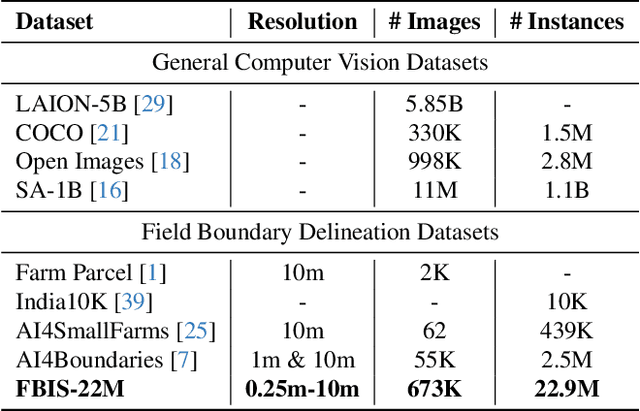
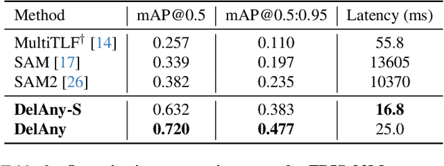
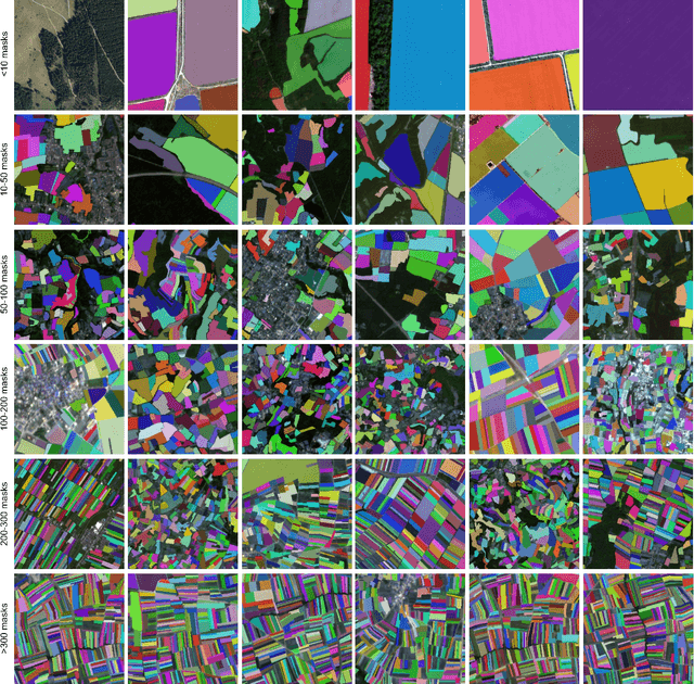
The accurate delineation of agricultural field boundaries from satellite imagery is vital for land management and crop monitoring. However, current methods face challenges due to limited dataset sizes, resolution discrepancies, and diverse environmental conditions. We address this by reformulating the task as instance segmentation and introducing the Field Boundary Instance Segmentation - 22M dataset (FBIS-22M), a large-scale, multi-resolution dataset comprising 672,909 high-resolution satellite image patches (ranging from 0.25 m to 10 m) and 22,926,427 instance masks of individual fields, significantly narrowing the gap between agricultural datasets and those in other computer vision domains. We further propose Delineate Anything, an instance segmentation model trained on our new FBIS-22M dataset. Our proposed model sets a new state-of-the-art, achieving a substantial improvement of 88.5% in mAP@0.5 and 103% in mAP@0.5:0.95 over existing methods, while also demonstrating significantly faster inference and strong zero-shot generalization across diverse image resolutions and unseen geographic regions. Code, pre-trained models, and the FBIS-22M dataset are available at https://lavreniuk.github.io/Delineate-Anything.