 Add to Chrome
 Add to Firefox
 Add to Edge
Beyond the Laplacian: Doubly Stochastic Matrices for Graph Neural Networks
Apr 16, 2026Graph Neural Networks (GNNs) conventionally rely on standard Laplacian or adjacency matrices for structural message passing. In this work, we substitute the traditional Laplacian with a Doubly Stochastic graph Matrix (DSM), derived from the inverse of the modified Laplacian, to naturally encode continuous multi-hop proximity and strict local centrality. To overcome the intractable $O(n^3)$ complexity of exact matrix inversion, we first utilize a truncated Neumann series to scalably approximate the DSM, which serves as the foundation for our proposed DsmNet. Furthermore, because algebraic truncation inherently causes probability mass leakage, we introduce DsmNet-compensate. This variant features a mathematically rigorous Residual Mass Compensation mechanism that analytically re-injects the truncated tail mass into self-loops, strictly restoring row-stochasticity and structural dominance. Extensive theoretical and empirical analyses demonstrate that our decoupled architectures operate efficiently in $O(K|E|)$ time and effectively mitigate over-smoothing by bounding Dirichlet energy decay, providing robust empirical validation on homophilic benchmarks. Finally, we establish the theoretical boundaries of the DSM on heterophilic topologies and demonstrate its versatility as a continuous structural encoding for Graph Transformers.
DOVA-PATBM: An Intelligent, Adaptive, and Scalable Framework for Optimizing Large-Scale EV Charging Infrastructure
Jun 18, 2025The accelerating uptake of battery-electric vehicles demands infrastructure planning tools that are both data-rich and geographically scalable. Whereas most prior studies optimise charging locations for single cities, state-wide and national networks must reconcile the conflicting requirements of dense metropolitan cores, car-dependent exurbs, and power-constrained rural corridors. We present DOVA-PATBM (Deployment Optimisation with Voronoi-oriented, Adaptive, POI-Aware Temporal Behaviour Model), a geo-computational framework that unifies these contexts in a single pipeline. The method rasterises heterogeneous data (roads, population, night lights, POIs, and feeder lines) onto a hierarchical H3 grid, infers intersection importance with a zone-normalised graph neural network centrality model, and overlays a Voronoi tessellation that guarantees at least one five-port DC fast charger within every 30 km radius. Hourly arrival profiles, learned from loop-detector and floating-car traces, feed a finite M/M/c queue to size ports under feeder-capacity and outage-risk constraints. A greedy maximal-coverage heuristic with income-weighted penalties then selects the minimum number of sites that satisfy coverage and equity targets. Applied to the State of Georgia, USA, DOVA-PATBM (i) increases 30 km tile coverage by 12 percentage points, (ii) halves the mean distance that low-income residents travel to the nearest charger, and (iii) meets sub-transmission headroom everywhere -- all while remaining computationally tractable for national-scale roll-outs. These results demonstrate that a tightly integrated, GNN-driven, multi-resolution approach can bridge the gap between academic optimisation and deployable infrastructure policy.
Impact of natural disasters on consumer behavior: case of the 2017 El Nino phenomenon in Peru
Aug 11, 2020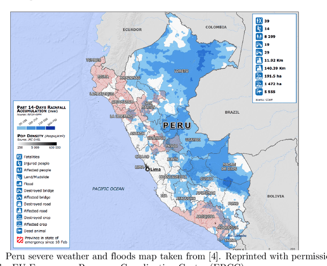
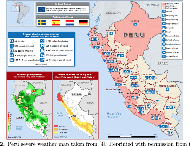
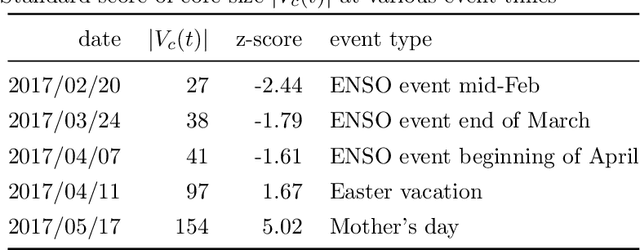
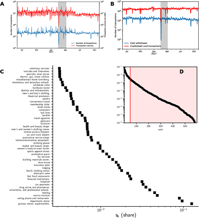
El Nino is an extreme weather event featuring unusual warming of surface waters in the eastern equatorial Pacific Ocean. This phenomenon is characterized by heavy rains and floods that negatively affect the economic activities of the impacted areas. Understanding how this phenomenon influences consumption behavior at different granularity levels is essential for recommending strategies to normalize the situation. With this aim, we performed a multi-scale analysis of data associated with bank transactions involving credit and debit cards. Our findings can be summarized into two main results: Coarse-grained analysis reveals the presence of the El Ni\~no phenomenon and the recovery time in a given territory, while fine-grained analysis demonstrates a change in individuals' purchasing patterns and in merchant relevance as a consequence of the climatic event. The results also indicate that society successfully withstood the natural disaster owing to the economic structure built over time. In this study, we present a new method that may be useful for better characterizing future extreme events.
CT-Mapper: Mapping Sparse Multimodal Cellular Trajectories using a Multilayer Transportation Network
Apr 22, 2016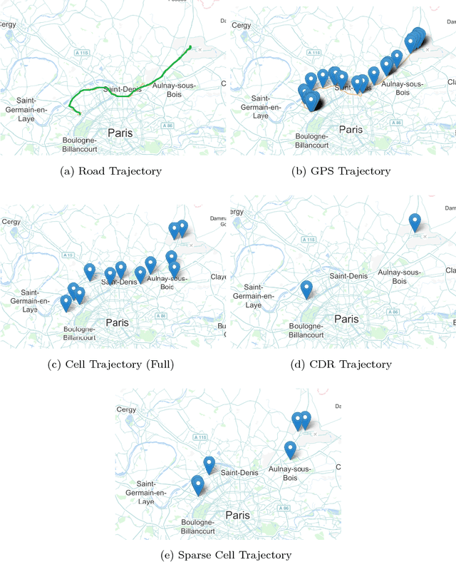
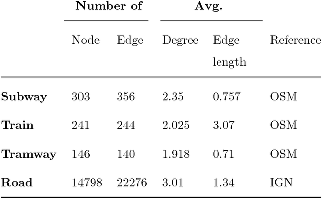
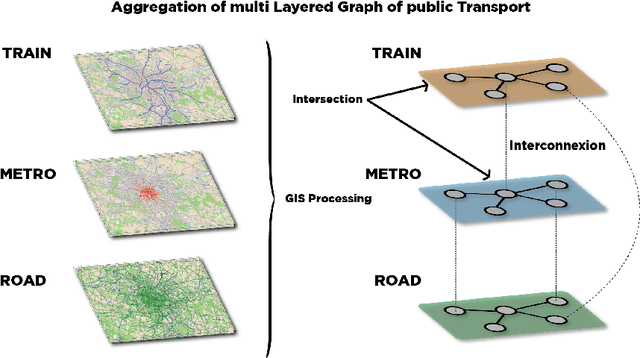
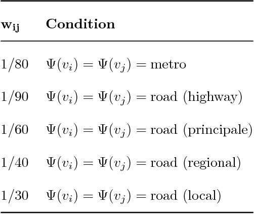
Mobile phone data have recently become an attractive source of information about mobility behavior. Since cell phone data can be captured in a passive way for a large user population, they can be harnessed to collect well-sampled mobility information. In this paper, we propose CT-Mapper, an unsupervised algorithm that enables the mapping of mobile phone traces over a multimodal transport network. One of the main strengths of CT-Mapper is its capability to map noisy sparse cellular multimodal trajectories over a multilayer transportation network where the layers have different physical properties and not only to map trajectories associated with a single layer. Such a network is modeled by a large multilayer graph in which the nodes correspond to metro/train stations or road intersections and edges correspond to connections between them. The mapping problem is modeled by an unsupervised HMM where the observations correspond to sparse user mobile trajectories and the hidden states to the multilayer graph nodes. The HMM is unsupervised as the transition and emission probabilities are inferred using respectively the physical transportation properties and the information on the spatial coverage of antenna base stations. To evaluate CT-Mapper we collected cellular traces with their corresponding GPS trajectories for a group of volunteer users in Paris and vicinity (France). We show that CT-Mapper is able to accurately retrieve the real cell phone user paths despite the sparsity of the observed trace trajectories. Furthermore our transition probability model is up to 20% more accurate than other naive models.