 Add to Chrome
 Add to Firefox
 Add to Edge
Monitoring the Impacts of a Tailings Dam Failure Using Satellite Images
Jan 30, 2021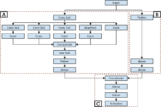
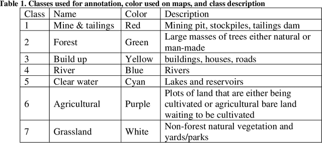
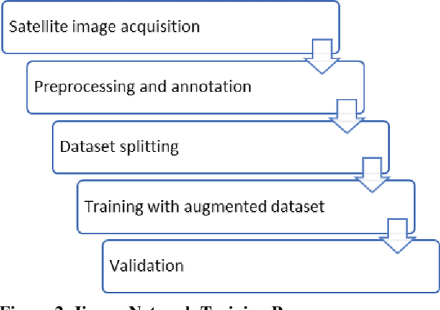
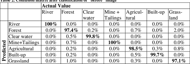
Monitoring dam failures using satellite images provides first responders with efficient management of early interventions. It is also equally important to monitor spatial and temporal changes in the inundation area to track the post-disaster recovery. On January 25th, 2019, the tailings dam of the C\'orrego do Feij\~ao iron ore mine, located in Brumadinho, Brazil, collapsed. This disaster caused more than 230 fatalities and 30 missing people leading to damage on the order of multiple billions of dollars. This study uses Sentinel-2 satellite images to map the inundation area and assess and delineate the land use and land cover impacted by the dam failure. The images correspond to data captures from January 22nd (3 days before), and February 02 (7 days after the collapse). Satellite images of the region were classified for before and aftermath of the disaster implementing a machine learning algorithm. In order to have sufficient land cover types to validate the quality and accuracy of the algorithm, 7 classes were defined: mine, forest, build-up, river, agricultural, clear water, and grassland. The developed classification algorithm yielded a high accuracy (99%) for the image before the collapse. This paper determines land cover impact using two different models, 1) by using the trained network in the "after" image, and 2) by creating a second network, trained in a subset of points of the "after" image, and then comparing the land cover results of the two trained networks. In the first model, applying the trained network to the "after" image, the accuracy is still high (86%), but lower than using the second model (98%). This strategy can be applied at a low cost for monitoring and assessment by using openly available satellite information and, in case of dam collapse or with a larger budget, higher resolution and faster data can be obtained by fly-overs on the area of concern.
Roof fall hazard detection with convolutional neural networks using transfer learning
Nov 12, 2020
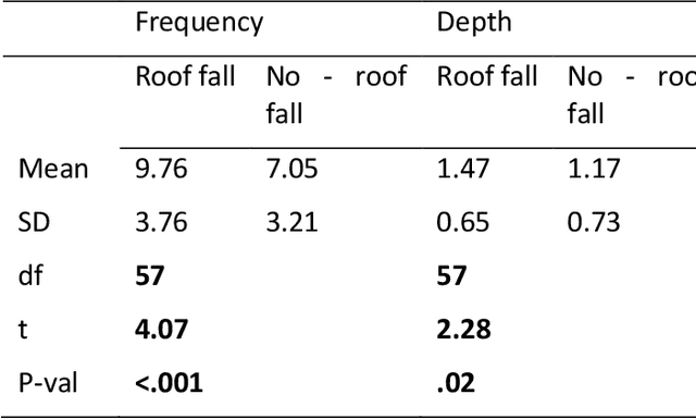
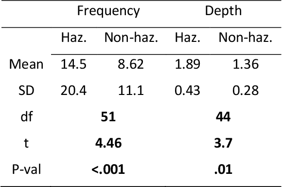
Roof falls due to geological conditions are major safety hazards in mining and tunneling industries, causing lost work times, injuries, and fatalities. Several large-opening limestone mines in the Eastern and Midwestern United States have roof fall problems caused by high horizontal stresses. The typical hazard management approach for this type of roof fall hazard relies heavily on visual inspections and expert knowledge. In this study, we propose an artificial intelligence (AI) based system for the detection roof fall hazards caused by high horizontal stresses. We use images depicting hazardous and non-hazardous roof conditions to develop a convolutional neural network for autonomous detection of hazardous roof conditions. To compensate for limited input data, we utilize a transfer learning approach. In transfer learning, an already-trained network is used as a starting point for classification in a similar domain. Results confirm that this approach works well for classifying roof conditions as hazardous or safe, achieving a statistical accuracy of 86%. However, accuracy alone is not enough to ensure a reliable hazard management system. System constraints and reliability are improved when the features being used by the network are understood. Therefore, we used a deep learning interpretation technique called integrated gradients to identify the important geologic features in each image for prediction. The analysis of integrated gradients shows that the system mimics expert judgment on roof fall hazard detection. The system developed in this paper demonstrates the potential of deep learning in geological hazard management to complement human experts, and likely to become an essential part of autonomous tunneling operations in those cases where hazard identification heavily depends on expert knowledge.