 Add to Chrome
 Add to Firefox
 Add to Edge
Beyond Land Surface Temperature: Explainable Spatial Machine Learning Reveals Urban Morphology Effects on Human-Centric Heat Stress
Apr 24, 2026Heat exposure connects the built environment and public health, directly shaping the livability and sustainability of urban areas. Understanding the spatial heterogeneity of heat exposure and its drivers is vital for climate-adaptive urban planning. However, most planning-oriented studies rely on land surface temperature (LST), and whether LST adequately represents human heat exposure and how it differs from physiologically relevant heat stress remains insufficiently examined. Here, adopting Landsat-retrieved 30-m LST and GPU-accelerated 1-m universal thermal climate index (UTCI) in Singapore, this study establishes a comprehensive "Modeling-Comparing-Assessing" framework to systematically evaluate the spatial and mechanistic discrepancies between the two metrics. We further investigate pronounced non-stationary and threshold-based quantitative relationships of the two metrics with urban factors by employing a novel geographically weighted XGBoost (GW-XGBoost) and generalized additive model (GAM) workflow. Our results demonstrate notable discrepancies in spatial patterns of LST and UTCI, along with substantial spatial heterogeneity in how 2D and 3D urban factors impact these two thermal metrics, as revealed by explainable GW-XGBoost models (global out-of-bag R2 = 0.855 for LST and 0.905 for UTCI, respectively). Crucially, spatially explicit SHAP interprets that sky view factor plays a central role in explaining UTCI variability but exhibits a comparatively marginal independent contribution to LST, indicating that LST inadequately captures shading-driven and radiative processes governing actual human heat stress. Notably, SHAP-GAM analysis indicates that higher albedo is associated with increased UTCI. These novel findings provide evidence for integrating physiologically relevant thermal indices to inform targeted heat risk management and climate-adaptive urban planning.
India nudges to contain COVID-19 pandemic: a reactive public policy analysis using machine-learning based topic modelling
May 14, 2020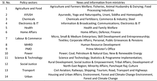
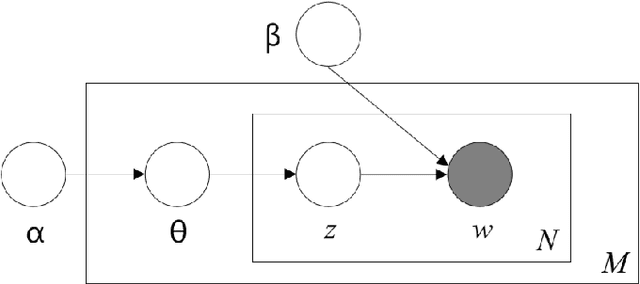
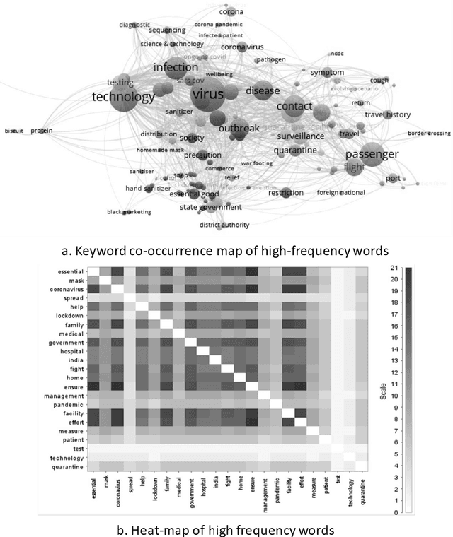
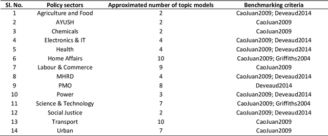
India locked down 1.3 billion people on March 25, 2020 in the wake of COVID-19 pandemic. The economic cost of it was estimated at USD 98 billion, while the social costs are still unknown. This study investigated how government formed reactive policies to fight coronavirus across its policy sectors. Primary data was collected from the Press Information Bureau (PIB) in the form press releases of government plans, policies, programme initiatives and achievements. A text corpus of 260,852 words was created from 396 documents from the PIB. An unsupervised machine-based topic modelling using Latent Dirichlet Allocation (LDA) algorithm was performed on the text corpus. It was done to extract high probability topics in the policy sectors. The interpretation of the extracted topics was made through a nudge theoretic lens to derive the critical policy heuristics of the government. Results showed that most interventions were targeted to generate endogenous nudge by using external triggers. Notably, the nudges from the Prime Minister of India was critical in creating herd effect on lockdown and social distancing norms across the nation. A similar effect was also observed around the public health (e.g., masks in public spaces; Yoga and Ayurveda for immunity), transport (e.g., old trains converted to isolation wards), micro, small and medium enterprises (e.g., rapid production of PPE and masks), science and technology sector (e.g., diagnostic kits, robots and nano-technology), home affairs (e.g., surveillance and lockdown), urban (e.g. drones, GIS-tools) and education (e.g., online learning). A conclusion was drawn on leveraging these heuristics are crucial for lockdown easement planning.