 Add to Chrome
 Add to Firefox
 Add to Edge
Inferring Height from Earth Embeddings: First insights using Google AlphaEarth
Feb 19, 2026This study investigates whether the geospatial and multimodal features encoded in \textit{Earth Embeddings} can effectively guide deep learning (DL) regression models for regional surface height mapping. In particular, we focused on AlphaEarth Embeddings at 10 m spatial resolution and evaluated their capability to support terrain height inference using a high-quality Digital Surface Model (DSM) as reference. U-Net and U-Net++ architectures were thus employed as lightweight convolutional decoders to assess how well the geospatial information distilled in the embeddings can be translated into accurate surface height estimates. Both architectures achieved strong training performance (both with $R^2 = 0.97$), confirming that the embeddings encode informative and decodable height-related signals. On the test set, performance decreased due to distribution shifts in height frequency between training and testing areas. Nevertheless, U-Net++ shows better generalization ($R^2 = 0.84$, median difference = -2.62 m) compared with the standard U-Net ($R^2 = 0.78$, median difference = -7.22 m), suggesting enhanced robustness to distribution mismatch. While the testing RMSE (approximately 16 m for U-Net++) and residual bias highlight remaining challenges in generalization, strong correlations indicate that the embeddings capture transferable topographic patterns. Overall, the results demonstrate the promising potential of AlphaEarth Embeddings to guide DL-based height mapping workflows, particularly when combined with spatially aware convolutional architectures, while emphasizing the need to address bias for improved regional transferability.
Inferring 3D change detection from bitemporal optical images
May 31, 2022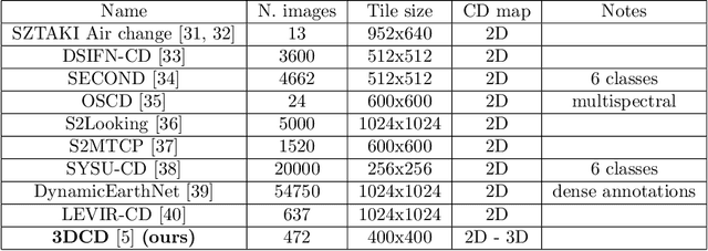
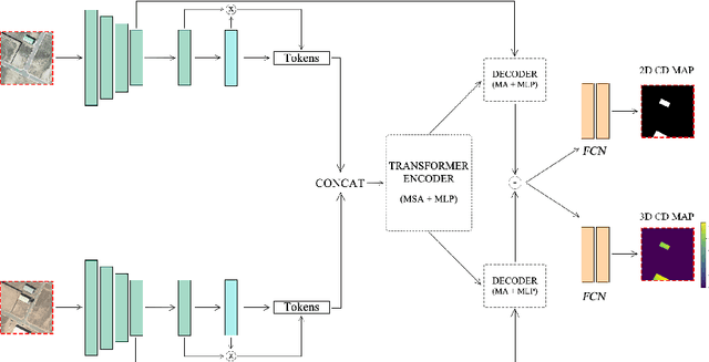
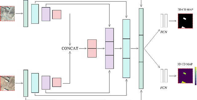
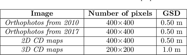
Change detection is one of the most active research areas in Remote Sensing (RS). Most of the recently developed change detection methods are based on deep learning (DL) algorithms. This kind of algorithms is generally focused on generating two-dimensional (2D) change maps, thus only identifying planimetric changes in land use/land cover (LULC) and not considering nor returning any information on the corresponding elevation changes. Our work goes one step further, proposing two novel networks, able to solve simultaneously the 2D and 3D CD tasks, and the 3DCD dataset, a novel and freely available dataset precisely designed for this multitask. Particularly, the aim of this work is to lay the foundations for the development of DL algorithms able to automatically infer an elevation (3D) CD map -- together with a standard 2D CD map --, starting only from a pair of bitemporal optical images. The proposed architectures, to perform the task described before, consist of a transformer-based network, the MultiTask Bitemporal Images Transformer (MTBIT), and a deep convolutional network, the Siamese ResUNet (SUNet). Particularly, MTBIT is a transformer-based architecture, based on a semantic tokenizer. SUNet instead combines, in a siamese encoder, skip connections and residual layers to learn rich features, capable to solve efficiently the proposed task. These models are, thus, able to obtain 3D CD maps from two optical images taken at different time instants, without the need to rely directly on elevation data during the inference step. Encouraging results, obtained on the novel 3DCD dataset, are shown. The code and the 3DCD dataset are available at \url{https://sites.google.com/uniroma1.it/3dchangedetection/home-page}.