 Add to Chrome
 Add to Firefox
 Add to Edge
Kimi K3: Open Frontier Intelligence
Jul 27, 2026
We introduce Kimi K3, a 2.8T parameter Mixture-of-Experts model with 104 billion activated parameters, native vision capabilities, and a 1-million-token context window. Kimi K3 is built on Kimi Delta Attention and Attention Residuals, which improve information flow across sequence length and model depth. Together with Stable LatentMoE, which effectively activates 16 of 896 routed experts per token, and refined training and data recipes, these advances yield an approximately 2.5x improvement in overall scaling efficiency over Kimi K2. Post-training highlights reinforcement learning across general, agentic, and coding domains and multiple reasoning-effort levels, enabling compositional generalization and robust long-horizon execution. At 2.8T scale, Kimi K3 is supported by infrastructure advances in multiple areas: algorithm-system co-design for KDA, perfectly balanced expert-parallel training with efficient memory management, million-token agentic RL with persistent rollout and sandbox states, and deployment innovations. Extensive evaluations show that Kimi K3 achieves frontier-level performance across long-horizon coding, agentic, knowledge, reasoning, and vision tasks. While its overall performance still trails the most powerful proprietary models, namely Claude Fable 5 and GPT-5.6 Sol, Kimi K3 consistently outperforms other open and proprietary models evaluated in our suite. We release the full Kimi K3 model weights to facilitate future research and accelerate the broader deployment and adoption of frontier intelligence.

First Mapping the Canopy Height of Primeval Forests in the Tallest Tree Area of Asia
Apr 23, 2024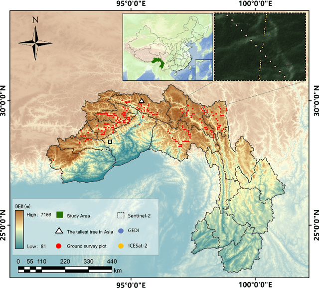
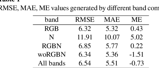
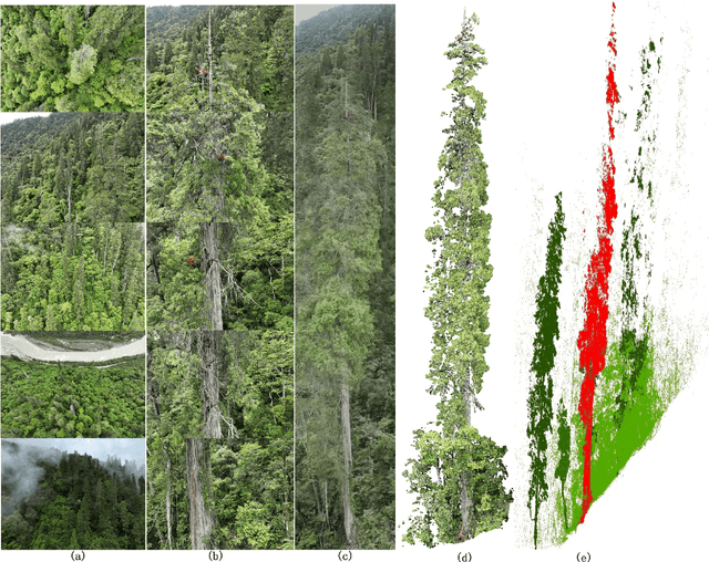
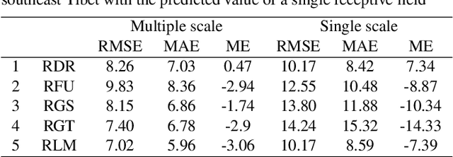
We have developed the world's first canopy height map of the distribution area of world-level giant trees. This mapping is crucial for discovering more individual and community world-level giant trees, and for analyzing and quantifying the effectiveness of biodiversity conservation measures in the Yarlung Tsangpo Grand Canyon (YTGC) National Nature Reserve. We proposed a method to map the canopy height of the primeval forest within the world-level giant tree distribution area by using a spaceborne LiDAR fusion satellite imagery (Global Ecosystem Dynamics Investigation (GEDI), ICESat-2, and Sentinel-2) driven deep learning modeling. And we customized a pyramid receptive fields depth separable CNN (PRFXception). PRFXception, a CNN architecture specifically customized for mapping primeval forest canopy height to infer the canopy height at the footprint level of GEDI and ICESat-2 from Sentinel-2 optical imagery with a 10-meter spatial resolution. We conducted a field survey of 227 permanent plots using a stratified sampling method and measured several giant trees using UAV-LS. The predicted canopy height was compared with ICESat-2 and GEDI validation data (RMSE =7.56 m, MAE=6.07 m, ME=-0.98 m, R^2=0.58 m), UAV-LS point clouds (RMSE =5.75 m, MAE =3.72 m, ME = 0.82 m, R^2= 0.65 m), and ground survey data (RMSE = 6.75 m, MAE = 5.56 m, ME= 2.14 m, R^2=0.60 m). We mapped the potential distribution map of world-level giant trees and discovered two previously undetected giant tree communities with an 89% probability of having trees 80-100 m tall, potentially taller than Asia's tallest tree. This paper provides scientific evidence confirming southeastern Tibet--northwestern Yunnan as the fourth global distribution center of world-level giant trees initiatives and promoting the inclusion of the YTGC giant tree distribution area within the scope of China's national park conservation.