 Add to Chrome
 Add to Firefox
 Add to Edge
Latent-Constrained Conditional VAEs for Augmenting Large-Scale Climate Ensembles
Jan 01, 2026Large climate-model ensembles are computationally expensive; yet many downstream analyses would benefit from additional, statistically consistent realizations of spatiotemporal climate variables. We study a generative modeling approach for producing new realizations from a limited set of available runs by transferring structure learned across an ensemble. Using monthly near-surface temperature time series from ten independent reanalysis realizations (ERA5), we find that a vanilla conditional variational autoencoder (CVAE) trained jointly across realizations yields a fragmented latent space that fails to generalize to unseen ensemble members. To address this, we introduce a latent-constrained CVAE (LC-CVAE) that enforces cross-realization homogeneity of latent embeddings at a small set of shared geographic 'anchor' locations. We then use multi-output Gaussian process regression in the latent space to predict latent coordinates at unsampled locations in a new realization, followed by decoding to generate full time series fields. Experiments and ablations demonstrate (i) instability when training on a single realization, (ii) diminishing returns after incorporating roughly five realizations, and (iii) a trade-off between spatial coverage and reconstruction quality that is closely linked to the average neighbor distance in latent space.
Segmenting objects with Bayesian fusion of active contour models and convnet priors
Oct 09, 2024


Instance segmentation is a core computer vision task with great practical significance. Recent advances, driven by large-scale benchmark datasets, have yielded good general-purpose Convolutional Neural Network (CNN)-based methods. Natural Resource Monitoring (NRM) utilizes remote sensing imagery with generally known scale and containing multiple overlapping instances of the same class, wherein the object contours are jagged and highly irregular. This is in stark contrast with the regular man-made objects found in classic benchmark datasets. We address this problem and propose a novel instance segmentation method geared towards NRM imagery. We formulate the problem as Bayesian maximum a posteriori inference which, in learning the individual object contours, incorporates shape, location, and position priors from state-of-the-art CNN architectures, driving a simultaneous level-set evolution of multiple object contours. We employ loose coupling between the CNNs that supply the priors and the active contour process, allowing a drop-in replacement of new network architectures. Moreover, we introduce a novel prior for contour shape, namely, a class of Deep Shape Models based on architectures from Generative Adversarial Networks (GANs). These Deep Shape Models are in essence a non-linear generalization of the classic Eigenshape formulation. In experiments, we tackle the challenging, real-world problem of segmenting individual dead tree crowns and delineating precise contours. We compare our method to two leading general-purpose instance segmentation methods - Mask R-CNN and K-net - on color infrared aerial imagery. Results show our approach to significantly outperform both methods in terms of reconstruction quality of tree crown contours. Furthermore, use of the GAN-based deep shape model prior yields significant improvement of all results over the vanilla Eigenshape prior.
A hybrid convolutional neural network/active contour approach to segmenting dead trees in aerial imagery
Dec 06, 2021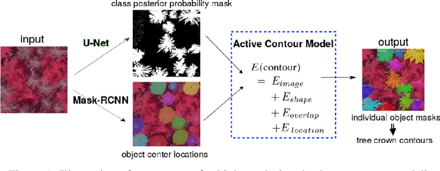
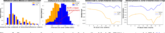
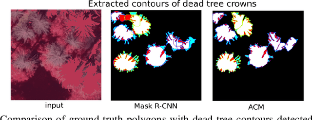
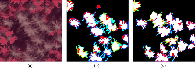
The stability and ability of an ecosystem to withstand climate change is directly linked to its biodiversity. Dead trees are a key indicator of overall forest health, housing one-third of forest ecosystem biodiversity, and constitute 8%of the global carbon stocks. They are decomposed by several natural factors, e.g. climate, insects and fungi. Accurate detection and modeling of dead wood mass is paramount to understanding forest ecology, the carbon cycle and decomposers. We present a novel method to construct precise shape contours of dead trees from aerial photographs by combining established convolutional neural networks with a novel active contour model in an energy minimization framework. Our approach yields superior performance accuracy over state-of-the-art in terms of precision, recall, and intersection over union of detected dead trees. This improved performance is essential to meet emerging challenges caused by climate change (and other man-made perturbations to the systems), particularly to monitor and estimate carbon stock decay rates, monitor forest health and biodiversity, and the overall effects of dead wood on and from climate change.
In the Danger Zone: U-Net Driven Quantile Regression can Predict High-risk SARS-CoV-2 Regions via Pollutant Particulate Matter and Satellite Imagery
May 06, 2021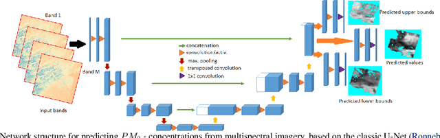
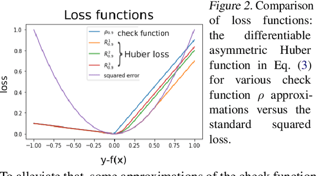
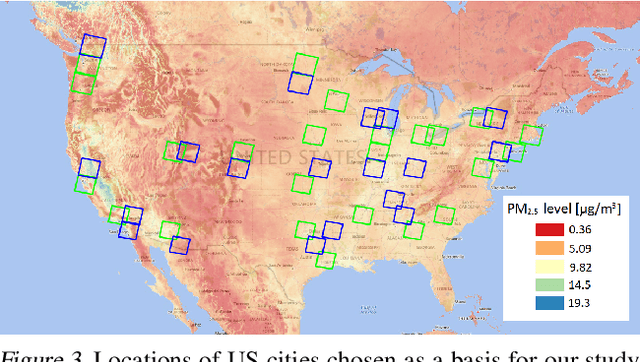
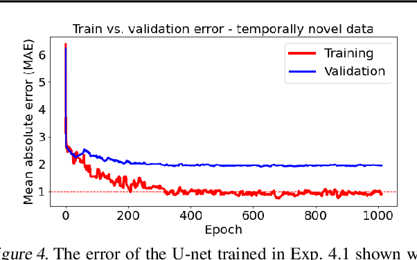
Since the outbreak of COVID-19 policy makers have been relying upon non-pharmacological interventions to control the outbreak. With air pollution as a potential transmission vector there is need to include it in intervention strategies. We propose a U-net driven quantile regression model to predict $PM_{2.5}$ air pollution based on easily obtainable satellite imagery. We demonstrate that our approach can reconstruct $PM_{2.5}$ concentrations on ground-truth data and predict reasonable $PM_{2.5}$ values with their spatial distribution, even for locations where pollution data is unavailable. Such predictions of $PM_{2.5}$ characteristics could crucially advise public policy strategies geared to reduce the transmission of and lethality of COVID-19.
Instance segmentation of fallen trees in aerial color infrared imagery using active multi-contour evolution with fully convolutional network-based intensity priors
May 05, 2021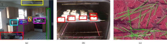
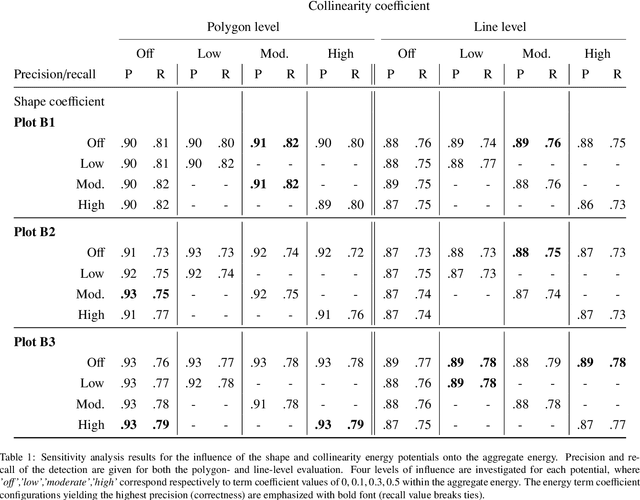
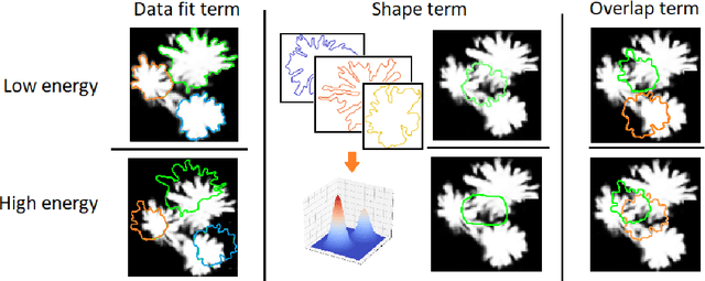
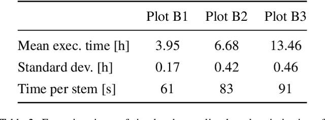
In this paper, we introduce a framework for segmenting instances of a common object class by multiple active contour evolution over semantic segmentation maps of images obtained through fully convolutional networks. The contour evolution is cast as an energy minimization problem, where the aggregate energy functional incorporates a data fit term, an explicit shape model, and accounts for object overlap. Efficient solution neighborhood operators are proposed, enabling optimization through metaheuristics such as simulated annealing. We instantiate the proposed framework in the context of segmenting individual fallen stems from high-resolution aerial multispectral imagery. We validated our approach on 3 real-world scenes of varying complexity. The test plots were situated in regions of the Bavarian Forest National Park, Germany, which sustained a heavy bark beetle infestation. Evaluations were performed on both the polygon and line segment level, showing that the multi-contour segmentation can achieve up to 0.93 precision and 0.82 recall. An improvement of up to 7 percentage points (pp) in recall and 6 in precision compared to an iterative sample consensus line segment detection was achieved. Despite the simplicity of the applied shape parametrization, an explicit shape model incorporated into the energy function improved the results by up to 4 pp of recall. Finally, we show the importance of using a deep learning based semantic segmentation method as the basis for individual stem detection. Our method is a step towards increased accessibility of automatic fallen tree mapping, due to higher cost efficiency of aerial imagery acquisition compared to laser scanning. The precise fallen tree maps could be further used as a basis for plant and animal habitat modeling, studies on carbon sequestration as well as soil quality in forest ecosystems.