 Add to Chrome
 Add to Firefox
 Add to Edge
Deep Learning based Detection of Fishing Vessels and Fishing Monitoring using Nightlight Images
Aug 10, 2026
The demand for maritime surveillance has given rise to the need for monitoring fishing vessel activities, particularly in addressing the challenge of "dark vessels" that operate without Automatic Identification System (AIS) transmission. This study presents a novel approach for detecting small-scale fishing vessels using nighttime light (NTL) imagery from the SDGSAT-1 satellite, combined with deep learning techniques to enhance fishing monitoring awareness along the western coast of India. A dual-branch YOLO11 architecture was developed to exploit both the 10-meter panchromatic and 40-meter RGB imagery from SDGSAT-1. The custom model architecture was specifically optimized for small object detection in NTL imagery, featuring parallel convolutional backbones that process both modalities before concatenation for enhanced feature extraction. The dual-branch YOLO11 model demonstrated optimal performance with a precision of 0.99, recall of 0.93, F1-score of 0.96, and mAP@50 of 0.96, significantly outperforming single-branch implementations of YOLOv5s, YOLOv8s, and standard YOLO11s architectures. When applied to the western coast of India, the model detected 31525 vessel instances across the temporal dataset spanning 2022-23. Cross-matching analysis with AIS data revealed that only 7146 (22.7%) of detected vessels had corresponding AIS transmissions, while 24379 (77.3%) were identified as potential dark vessels. Spatio-temporal analysis showed peak fishing activity during January-April, with a primary activity corridor parallel to the coastline within 50-100 km, corresponding to productive continental shelf areas. This research contributes to maritime surveillance capabilities by highlighting the effectiveness of nighttime lights satellite imagery for fishing vessel detection and provides valuable insights into fishing patterns and potential regulatory compliance issues in Indian waters.

Multiresolution Fully Convolutional Networks to detect Clouds and Snow through Optical Satellite Images
Jan 07, 2022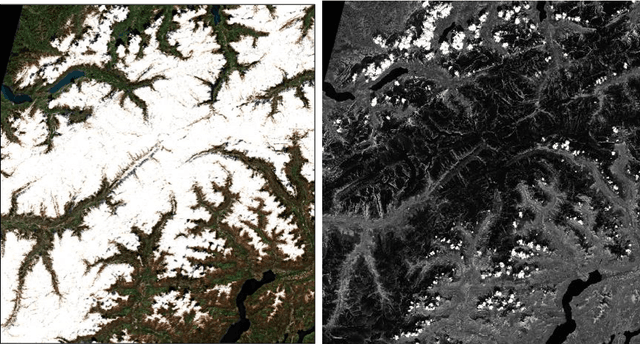
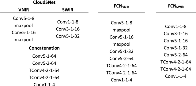
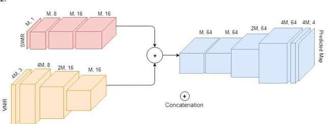

Clouds and snow have similar spectral features in the visible and near-infrared (VNIR) range and are thus difficult to distinguish from each other in high resolution VNIR images. We address this issue by introducing a shortwave-infrared (SWIR) band where clouds are highly reflective, and snow is absorptive. As SWIR is typically of a lower resolution compared to VNIR, this study proposes a multiresolution fully convolutional neural network (FCN) that can effectively detect clouds and snow in VNIR images. We fuse the multiresolution bands within a deep FCN and perform semantic segmentation at the higher, VNIR resolution. Such a fusion-based classifier, trained in an end-to-end manner, achieved 94.31% overall accuracy and an F1 score of 97.67% for clouds on Resourcesat-2 data captured over the state of Uttarakhand, India. These scores were found to be 30% higher than a Random Forest classifier, and 10% higher than a standalone single-resolution FCN. Apart from being useful for cloud detection purposes, the study also highlights the potential of convolutional neural networks for multi-sensor fusion problems.