 Add to Chrome
 Add to Firefox
 Add to Edge
Viking Hill Dataset: A Lidar-Radar-Camera Dataset for Detection and Segmentation in Forest Scenes
Jun 17, 2026
Autonomous robots operating under forest canopies need robust perception of trees and surrounding vegetation across varying seasonal conditions. Existing forestry datasets provide lidar or camera data with per-tree annotations, but none include co-registered 4D imaging radar -- a modality of growing interest for its resilience to visual degradation, surface contamination, and vegetation occlusion. We introduce a multi-sensor forest dataset collected by a mobile robot equipped with a high-resolution FMCW imaging radar, lidar, RGB camera, IMU, and RTK-GNSS. The site was recorded in two sessions under contrasting vegetation states, and 3D cuboid annotations -- including per-tree diameter estimates -- provide shared semantic labels across all three perception modalities. Furthermore, we provide baseline results for semantic segmentation of the radar and lidar point clouds using MinkowskiUNet. Radar achieves IoU scores competitive with lidar for dominant classes (ground 91%, canopy 86%) while lagging on geometrically fine structures such as tree trunks (56% vs. 74%). A cross-modality analysis further compares lidar and radar trunk segmentation against an RGB detection model, and a diameter-stratified evaluation reveals how trunk segmentation quality varies with tree size. Beyond segmentation, the co-registered multi-modal data and RTK-GNSS-aided reference positioning support research in mapping, localization, and sensor fusion under canopy. The dataset and annotation tools are publicly available.

Human Detection from 4D Radar Data in Low-Visibility Field Conditions
Apr 08, 2024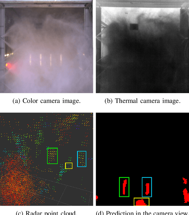

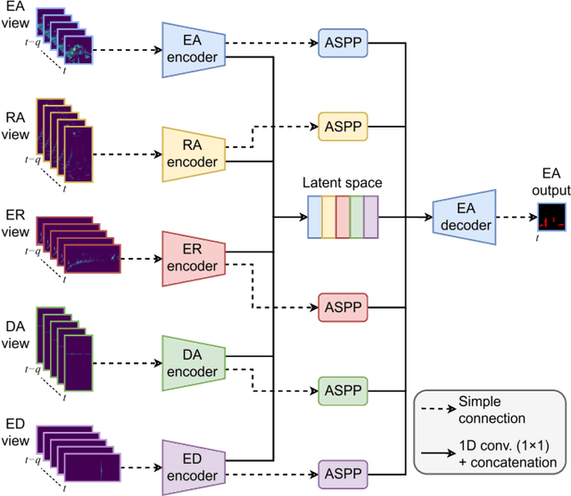

Autonomous driving technology is increasingly being used on public roads and in industrial settings such as mines. While it is essential to detect pedestrians, vehicles, or other obstacles, adverse field conditions negatively affect the performance of classical sensors such as cameras or lidars. Radar, on the other hand, is a promising modality that is less affected by, e.g., dust, smoke, water mist or fog. In particular, modern 4D imaging radars provide target responses across the range, vertical angle, horizontal angle and Doppler velocity dimensions. We propose TMVA4D, a CNN architecture that leverages this 4D radar modality for semantic segmentation. The CNN is trained to distinguish between the background and person classes based on a series of 2D projections of the 4D radar data that include the elevation, azimuth, range, and Doppler velocity dimensions. We also outline the process of compiling a novel dataset consisting of data collected in industrial settings with a car-mounted 4D radar and describe how the ground-truth labels were generated from reference thermal images. Using TMVA4D on this dataset, we achieve an mIoU score of 78.2% and an mDice score of 86.1%, evaluated on the two classes background and person