 Add to Chrome
 Add to Firefox
 Add to Edge
High-Resolution Forest Mapping from L-Band Interferometric SAR Time Series using Deep Learning over Northern Spain
Nov 06, 2025In this study, we examine the potential of high-resolution forest mapping using L-band interferometric time series datasets and deep learning modeling. Our SAR data are represented by a time series of nine ALOS-2 PALSAR-2 dual-pol SAR images acquired at near-zero spatial baseline over a study site in Asturias, Northern Spain. Reference data are collected using airborne laser scanning. We examine the performance of several candidate deep learning models from UNet-family with various combinations of input polarimetric and interferometric features. In addition to basic Vanilla UNet, attention reinforced UNet model with squeeze-excitation blocks (SeU-Net) and advanced UNet model with nested structure and skip pathways are used. Studied features include dual pol interferometric observables additionally incorporating model-based derived measures. Results show that adding model-based inverted InSAR features or InSAR coherence layers improves retrieval accuracy compared to using backscatter intensity only. Use of attention mechanisms and nested connection fusion provides better predictions than using Vanilla UNet or traditional machine learning methods. Forest height retrieval accuracies range between 3.1-3.8 m (R2 = 0.45--0.55) at 20 m resolution when only intensity data are used, and improve to less than 2.8 m when both intensity and interferometric coherence features are included. At 40 m and 60 m resolution, retrieval performance further improves, primarily due to higher SNR in both the intensity and interferometric layers. When using intensity at 60 m resolution, best achieved RMSE is 2.2 m, while when using all suitable input features the achieved error is 1.95 m. We recommend this hybrid approach for L-band SAR retrievals also suitable for NISAR and future ROSE-L missions.
Deep Learning Model Transfer in Forest Mapping using Multi-source Satellite SAR and Optical Images
Aug 09, 2023


Deep learning (DL) models are gaining popularity in forest variable prediction using Earth Observation images. However, in practical forest inventories, reference datasets are often represented by plot- or stand-level measurements, while high-quality representative wall-to-wall reference data for end-to-end training of DL models are rarely available. Transfer learning facilitates expansion of the use of deep learning models into areas with sub-optimal training data by allowing pretraining of the model in areas where high-quality teaching data are available. In this study, we perform a "model transfer" (or domain adaptation) of a pretrained DL model into a target area using plot-level measurements and compare performance versus other machine learning models. We use an earlier developed UNet based model (SeUNet) to demonstrate the approach on two distinct taiga sites with varying forest structure and composition. Multisource Earth Observation (EO) data are represented by a combination of Copernicus Sentinel-1 C-band SAR and Sentinel-2 multispectral images, JAXA ALOS-2 PALSAR-2 SAR mosaic and TanDEM-X bistatic interferometric radar data. The training study site is located in Finnish Lapland, while the target site is located in Southern Finland. By leveraging transfer learning, the prediction of SeUNet achieved root mean squared error (RMSE) of 2.70 m and R$^2$ of 0.882, considerably more accurate than traditional benchmark methods. We expect such forest-specific DL model transfer can be suitable also for other forest variables and other EO data sources that are sensitive to forest structure.
A Novel Semisupervised Contrastive Regression Framework for Forest Inventory Mapping with Multisensor Satellite Data
Dec 01, 2022


Accurate mapping of forests is critical for forest management and carbon stocks monitoring. Deep learning is becoming more popular in Earth Observation (EO), however, the availability of reference data limits its potential in wide-area forest mapping. To overcome those limitations, here we introduce contrastive regression into EO based forest mapping and develop a novel semisupervised regression framework for wall-to-wall mapping of continuous forest variables. It combines supervised contrastive regression loss and semi-supervised Cross-Pseudo Regression loss. The framework is demonstrated over a boreal forest site using Copernicus Sentinel-1 and Sentinel-2 imagery for mapping forest tree height. Achieved prediction accuracies are strongly better compared to using vanilla UNet or traditional regression models, with relative RMSE of 15.1% on stand level. We expect that developed framework can be used for modeling other forest variables and EO datasets.
ICEYE microsatellite SAR constellation status update: Evaluation of first commercial imaging modes
Feb 08, 2021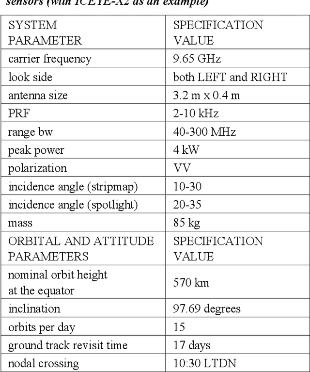
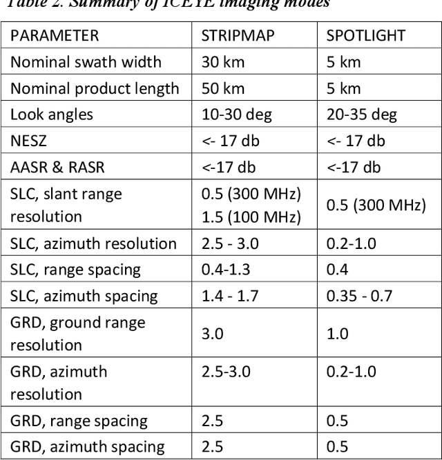
The ICEYE constellation features the first operational microsatellite based X-band SAR sensors suitable for all weather day-and-night Earth Observation. In this paper, we report on the status of the ICEYE Constellation and describe the characteristics of the first operational imaging modes.
Wide-Area Land Cover Mapping with Sentinel-1 Imagery using Deep Learning Semantic Segmentation Models
Dec 11, 2019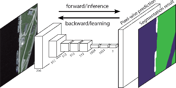
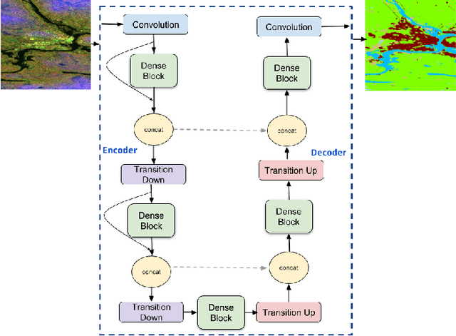
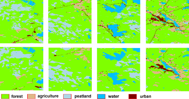
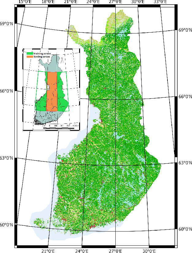
Land cover mapping and monitoring are essential for understanding the environment and the effects of human activities on it. The automatic approaches to land cover mapping are predominantly based on the traditional machine learning that requires heuristic feature design. Such approaches are relatively slow and often suitable only for a particular type of satellite sensor or geographical area. Recently, deep learning has outperformed traditional machine learning approaches on a range of image processing tasks including image classification and segmentation. In this study, we demonstrated the suitability of deep learning models for wide-area land cover mapping using satellite C-band SAR images. We used a set of 14 ESA Sentinel-1 scenes acquired during the summer season in Finland representative of the land cover in the country. These imageries were used as an input to seven state-of-the-art deep-learning models for semantic segmentation, namely U-Net, DeepLabV3+, PSPNet, BiSeNet, SegNet, FC-DenseNet, and FRRN-B. These models were pre-trained on the ImageNet dataset and further fine-tuned in this study. CORINE land cover map produced by the Finnish Environment Institute was used as a reference, and the models were trained to distinguish between 5 Level-1 CORINE classes. Upon the evaluation and benchmarking, we found that all the models demonstrated solid performance, with the top FC-DenseNet model achieving an overall accuracy of 90.7%. These results indicate the suitability of deep learning methods to support efficient wide-area mapping using satellite SAR imagery.