 Add to Chrome
 Add to Firefox
 Add to Edge
M-SGWR: Multiscale Similarity and Geographically Weighted Regression
Jan 27, 2026The first law of geography is a cornerstone of spatial analysis, emphasizing that nearby and related locations tend to be more similar, however, defining what constitutes "near" and "related" remains challenging, as different phenomena exhibit distinct spatial patterns. Traditional local regression models, such as Geographically Weighted Regression (GWR) and Multiscale GWR (MGWR), quantify spatial relationships solely through geographic proximity. In an era of globalization and digital connectivity, however, geographic proximity alone may be insufficient to capture how locations are interconnected. To address this limitation, we propose a new multiscale local regression framework, termed M-SGWR, which characterizes spatial interaction across two dimensions: geographic proximity and attribute (variable) similarity. For each predictor, geographic and attribute-based weight matrices are constructed separately and then combined using an optimized parameter, alpha, which governs their relative contribution to local model fitting. Analogous to variable-specific bandwidths in MGWR, the optimal alpha varies by predictor, allowing the model to flexibly account for geographic, mixed, or non-spatial (remote similarity) effects. Results from two simulation experiments and one empirical application demonstrate that M-SGWR consistently outperforms GWR, SGWR, and MGWR across all goodness-of-fit metrics.
SIM: A mapping framework for built environment auditing based on street view imagery
May 29, 2025Built environment auditing refers to the systematic documentation and assessment of urban and rural spaces' physical, social, and environmental characteristics, such as walkability, road conditions, and traffic lights. It is used to collect data for the evaluation of how built environments impact human behavior, health, mobility, and overall urban functionality. Traditionally, built environment audits were conducted using field surveys and manual observations, which were time-consuming and costly. The emerging street view imagery, e.g., Google Street View, has become a widely used data source for conducting built environment audits remotely. Deep learning and computer vision techniques can extract and classify objects from street images to enhance auditing productivity. Before meaningful analysis, the detected objects need to be geospatially mapped for accurate documentation. However, the mapping methods and tools based on street images are underexplored, and there are no universal frameworks or solutions yet, imposing difficulties in auditing the street objects. In this study, we introduced an open source street view mapping framework, providing three pipelines to map and measure: 1) width measurement for ground objects, such as roads; 2) 3D localization for objects with a known dimension (e.g., doors and stop signs); and 3) diameter measurements (e.g., street trees). These pipelines can help researchers, urban planners, and other professionals automatically measure and map target objects, promoting built environment auditing productivity and accuracy. Three case studies, including road width measurement, stop sign localization, and street tree diameter measurement, are provided in this paper to showcase pipeline usage.
Beyond Words: Evaluating Large Language Models in Transportation Planning
Sep 22, 2024


The resurgence and rapid advancement of Generative Artificial Intelligence (GenAI) in 2023 has catalyzed transformative shifts across numerous industry sectors, including urban transportation and logistics. This study investigates the evaluation of Large Language Models (LLMs), specifically GPT-4 and Phi-3-mini, to enhance transportation planning. The study assesses the performance and spatial comprehension of these models through a transportation-informed evaluation framework that includes general geospatial skills, general transportation domain skills, and real-world transportation problem-solving. Utilizing a mixed-methods approach, the research encompasses an evaluation of the LLMs' general Geographic Information System (GIS) skills, general transportation domain knowledge as well as abilities to support human decision-making in the real-world transportation planning scenarios of congestion pricing. Results indicate that GPT-4 demonstrates superior accuracy and reliability across various GIS and transportation-specific tasks compared to Phi-3-mini, highlighting its potential as a robust tool for transportation planners. Nonetheless, Phi-3-mini exhibits competence in specific analytical scenarios, suggesting its utility in resource-constrained environments. The findings underscore the transformative potential of GenAI technologies in urban transportation planning. Future work could explore the application of newer LLMs and the impact of Retrieval-Augmented Generation (RAG) techniques, on a broader set of real-world transportation planning and operations challenges, to deepen the integration of advanced AI models in transportation management practices.
Using Long Short-Term Memory and Internet of Things for localized surface temperature forecasting in an urban environment
Feb 04, 2021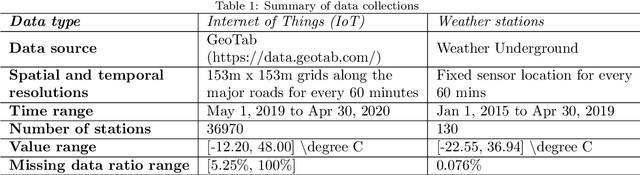
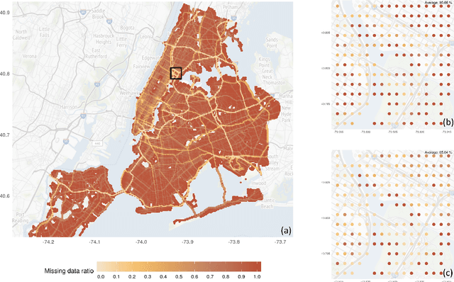
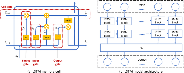
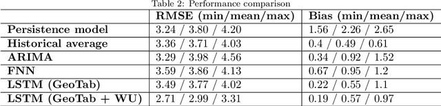
The rising temperature is one of the key indicators of a warming climate, and it can cause extensive stress to biological systems as well as built structures. Due to the heat island effect, it is most severe in urban environments compared to other landscapes due to the decrease in vegetation associated with a dense human-built environment. It is essential to adequately monitor the local temperature dynamics to mitigate risks associated with increasing temperatures, which can include short term strategy to protect people and animals, to long term strategy to how to build a new structure and cope with extreme events. Observed temperature is also a very important input for atmospheric models, and accurate data can lead to better future forecasts. Ambient temperature collected at ground level can have a higher variability when compared to regional weather forecasts, which fail to capture the local dynamics. There remains a clear need for an accurate air temperature prediction at the sub-urban scale at high temporal and spatial resolution. This research proposed a framework based on Long Short-Term Memory (LSTM) deep learning network to generate day-ahead hourly temperature forecast with high spatial resolution. A case study is shown which uses historical in-situ observations and Internet of Things (IoT) observations for New York City, USA. By leveraging the historical air temperature data from in-situ observations, the LSTM model can be exposed to more historical patterns that might not be present in the IoT observations. Meanwhile, by using IoT observations, the spatial resolution of air temperature predictions is significantly improved.